4825 products
-
 Peninsular and Valley Campaigns of 1862 from the American Civil War--maps 1910Peninsular and Valley Campaigns of 1862 from the American Civil War--maps 1910
- Regular price
-
$39.95 $83.95 - Regular price
-
$15.95 - Sale price
-
$39.95 $83.95
-
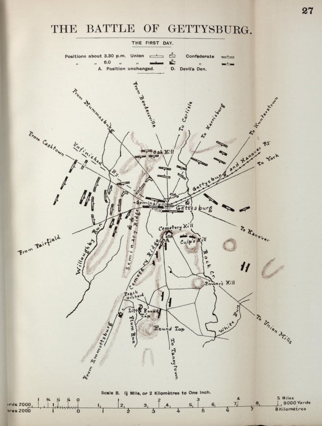 Battle of Gettysburg, the First Day from the American Civil War--maps 1910Battle of Gettysburg, the First Day from the American Civil War--maps 1910
- Regular price
-
$39.95 $88.95 - Regular price
-
$12.95 - Sale price
-
$39.95 $88.95
-
 Battle of Chattanooga from the American Civil War--maps 1910Battle of Chattanooga from the American Civil War--maps 1910
- Regular price
-
$39.95 $83.95 - Regular price
-
$18.95 - Sale price
-
$39.95 $83.95
-
 Grant's Dilemma, Dec. 1862 from the American Civil War--maps 1910Grant's Dilemma, Dec. 1862 from the American Civil War--maps 1910
- Regular price
-
$39.95 $83.95 - Regular price
-
$13.95 - Sale price
-
$39.95 $83.95
-
 Campaign of Shiloh from the American Civil War--maps 1910Campaign of Shiloh from the American Civil War--maps 1910
- Regular price
-
$39.95 $83.95 - Regular price
-
$17.95 - Sale price
-
$39.95 $83.95
-
 A Budhist Temple In Siam from Historical Hand-atlas, Illustrated, Containing Large Scale Copper Plate Maps of Each State and Territory of the United States, and the Provinces of Canada, Together With a Complete Reference Map of the World, … 1881A Budhist Temple In Siam from Historical Hand-atlas, Illustrated, Containing Large Scale Copper Plate Maps of Each State and Territory of the United States, and the Provinces of Canada, Together With a Complete Reference Map of the World, … 1881
- Regular price
-
$39.95 $88.95 - Regular price
-
$24.95 - Sale price
-
$39.95 $88.95
-
 Map of California and Nevada from Historical Hand-atlas, Illustrated, Containing Large Scale Copper Plate Maps of Each State and Territory of the United States, and the Provinces of Canada, Together With a Complete Reference Map of the World, … 1881Map of California and Nevada from Historical Hand-atlas, Illustrated, Containing Large Scale Copper Plate Maps of Each State and Territory of the United States, and the Provinces of Canada, Together With a Complete Reference Map of the World, … 1881
- Regular price
-
$39.95 $92.95 - Regular price
-
$36.95 - Sale price
-
$39.95 $92.95
-
 U.S. Census of 1880 from Historical Hand-atlas, Illustrated, Containing Large Scale Copper Plate Maps of Each State and Territory of the United States, and the Provinces of Canada, Together With a Complete Reference Map of the World, … 1881U.S. Census of 1880 from Historical Hand-atlas, Illustrated, Containing Large Scale Copper Plate Maps of Each State and Territory of the United States, and the Provinces of Canada, Together With a Complete Reference Map of the World, … 1881
- Regular price
-
$39.95 $88.95 - Regular price
-
$23.95 - Sale price
-
$39.95 $88.95
-
 Map of Pennsylvania from Historical Hand-atlas, Illustrated, Containing Large Scale Copper Plate Maps of Each State and Territory of the United States, and the Provinces of Canada, Together With a Complete Reference Map of the World, … 1881Map of Pennsylvania from Historical Hand-atlas, Illustrated, Containing Large Scale Copper Plate Maps of Each State and Territory of the United States, and the Provinces of Canada, Together With a Complete Reference Map of the World, … 1881
- Regular price
-
$39.95 $99.95 - Regular price
-
$36.95 - Sale price
-
$39.95 $99.95
-
 Ohio - Continued, Indiana from Historical Hand-atlas, Illustrated, Containing Large Scale Copper Plate Maps of Each State and Territory of the United States, and the Provinces of Canada, Together With a Complete Reference Map of the World, … 1881Ohio - Continued, Indiana from Historical Hand-atlas, Illustrated, Containing Large Scale Copper Plate Maps of Each State and Territory of the United States, and the Provinces of Canada, Together With a Complete Reference Map of the World, … 1881
- Regular price
-
$39.95 $88.95 - Regular price
-
$24.95 - Sale price
-
$39.95 $88.95
-
 Personal Histories - Continued from Historical Hand-atlas, Illustrated, Containing Large Scale Copper Plate Maps of Each State and Territory of the United States, and the Provinces of Canada, Together With a Complete Reference Map of the World, … 1881Personal Histories - Continued from Historical Hand-atlas, Illustrated, Containing Large Scale Copper Plate Maps of Each State and Territory of the United States, and the Provinces of Canada, Together With a Complete Reference Map of the World, … 1881
- Regular price
-
$39.95 $88.95 - Regular price
-
$25.95 - Sale price
-
$39.95 $88.95
-
 Map of the World from Historical Hand-atlas, Illustrated, Containing Large Scale Copper Plate Maps of Each State and Territory of the United States, and the Provinces of Canada, Together With a Complete Reference Map of the World, … 1881Map of the World from Historical Hand-atlas, Illustrated, Containing Large Scale Copper Plate Maps of Each State and Territory of the United States, and the Provinces of Canada, Together With a Complete Reference Map of the World, … 1881
- Regular price
-
$39.95 $99.95 - Regular price
-
$36.95 - Sale price
-
$39.95 $99.95


