428 products
-
 Map of the Shenandoah Valley, to Illustrate the Valley Campaign of Stonewall Jackson, 1862: 1880Map of the Shenandoah Valley, to Illustrate the Valley Campaign of Stonewall Jackson, 1862: 1880
- Regular price
-
$49.95 $83.95 - Regular price
-
$34.95 - Sale price
-
$49.95 $83.95
-
 Bird's Eye View of Philippi, West Virginia 1897Bird's Eye View of Philippi, West Virginia 1897
- Regular price
-
$49.95 $88.95 - Regular price
-
$29.95 - Sale price
-
$49.95 $88.95
-
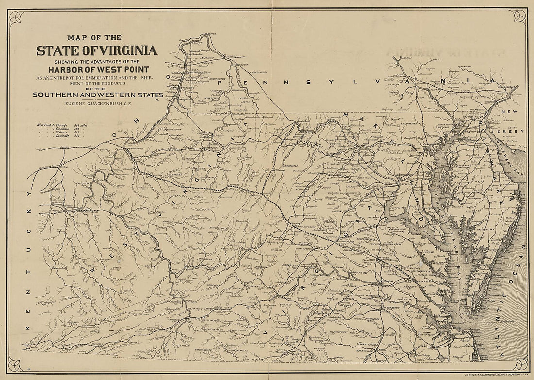 Map of the State of Virginia : Showing the Advantages of the Harbor of West Point As an Entrepot for Emmigration and the Shipment of the Products of the Southern and Western States 1875Map of the State of Virginia : Showing the Advantages of the Harbor of West Point As an Entrepot for Emmigration and the Shipment of the Products of the Southern and Western States 1875
- Regular price
-
$51.95 $182.95 - Regular price
-
$38.95 - Sale price
-
$51.95 $182.95
-
 Farm Line Map of Cass, Grant & Clay Dist's. Monongalia County and Part of Paw Paw Dist. Marion County, W. Va. (Farm Line Map of Cass, Grant and Clay Districts Monongalia County and Part of Paw Paw District Marion County, West Virginia) 1915Farm Line Map of Cass, Grant & Clay Dist's. Monongalia County and Part of Paw Paw Dist. Marion County, W. Va. (Farm Line Map of Cass, Grant and Clay Districts Monongalia County and Part of Paw Paw District Marion County, West Virginia) 1915
- Regular price
-
$54.95 $158.95 - Regular price
-
$38.95 - Sale price
-
$54.95 $158.95
-
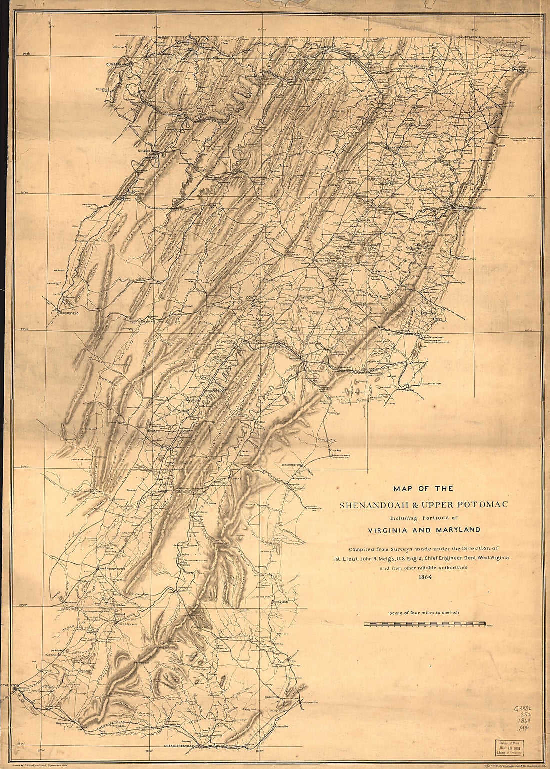 Map of the Shenandoah & Upper Potomac Including Portions of Virginia and Maryland 1864Map of the Shenandoah & Upper Potomac Including Portions of Virginia and Maryland 1864
- Regular price
-
$51.95 $168.95 - Regular price
-
$38.95 - Sale price
-
$51.95 $168.95
-
 Town of Phillippi, Barbour County, West Virginia. 1861Town of Phillippi, Barbour County, West Virginia. 1861
- Regular price
-
$58.95 $164.95 - Regular price
-
$41.95 - Sale price
-
$58.95 $164.95
-
 Luther's Home, In the Boulder Canyon, Falls Au Sable, New York from Historical Hand-atlas, Illustrated, Containing Large Scale Copper Plate Maps of Each State and Territory of the United States, and the Provinces of Canada, Together With a Complete Re...Luther's Home, In the Boulder Canyon, Falls Au Sable, New York from Historical Hand-atlas, Illustrated, Containing Large Scale Copper Plate Maps of Each State and Territory of the United States, and the Provinces of Canada, Together With a Complete Re...
- Regular price
-
$49.95 $88.95 - Regular price
-
$25.95 - Sale price
-
$49.95 $88.95
-
 Map of Oregon from Historical Hand-atlas, Illustrated, Containing Large Scale Copper Plate Maps of Each State and Territory of the United States, and the Provinces of Canada, Together With a Complete Reference Map of the World, … 1882Map of Oregon from Historical Hand-atlas, Illustrated, Containing Large Scale Copper Plate Maps of Each State and Territory of the United States, and the Provinces of Canada, Together With a Complete Reference Map of the World, … 1882
- Regular price
-
$49.95 $99.95 - Regular price
-
$36.95 - Sale price
-
$49.95 $99.95
-
 Louisiana - Continued, Texas from Historical Hand-atlas, Illustrated, Containing Large Scale Copper Plate Maps of Each State and Territory of the United States, and the Provinces of Canada, Together With a Complete Reference Map of the World, … 1882Louisiana - Continued, Texas from Historical Hand-atlas, Illustrated, Containing Large Scale Copper Plate Maps of Each State and Territory of the United States, and the Provinces of Canada, Together With a Complete Reference Map of the World, … 1882
- Regular price
-
$49.95 $99.95 - Regular price
-
$23.95 - Sale price
-
$49.95 $99.95
-
 History of Wood County - Continued from Historical Hand-atlas, Illustrated, Containing Large Scale Copper Plate Maps of Each State and Territory of the United States, and the Provinces of Canada, Together With a Complete Reference Map of the World, �...History of Wood County - Continued from Historical Hand-atlas, Illustrated, Containing Large Scale Copper Plate Maps of Each State and Territory of the United States, and the Provinces of Canada, Together With a Complete Reference Map of the World, �...
- Regular price
-
$49.95 $88.95 - Regular price
-
$23.95 - Sale price
-
$49.95 $88.95
-
 Personal History Department of Pleasants County - Continued from Historical Hand-atlas, Illustrated, Containing Large Scale Copper Plate Maps of Each State and Territory of the United States, and the Provinces of Canada, Together With a Complete Refer...Personal History Department of Pleasants County - Continued from Historical Hand-atlas, Illustrated, Containing Large Scale Copper Plate Maps of Each State and Territory of the United States, and the Provinces of Canada, Together With a Complete Refer...
- Regular price
-
$49.95 $88.95 - Regular price
-
$23.95 - Sale price
-
$49.95 $88.95
-
 History of the Virginias from Historical Hand-atlas, Illustrated, Containing Large Scale Copper Plate Maps of Each State and Territory of the United States, and the Provinces of Canada, Together With a Complete Reference Map of the World, … 1882History of the Virginias from Historical Hand-atlas, Illustrated, Containing Large Scale Copper Plate Maps of Each State and Territory of the United States, and the Provinces of Canada, Together With a Complete Reference Map of the World, … 1882
- Regular price
-
$49.95 $88.95 - Regular price
-
$22.95 - Sale price
-
$49.95 $88.95


