Quick links
11037 products
-
 Lincoln from Plat Book of Huron County, Michigan : Also Patron's Business and General Farmer's Directory of Huron County, Mich. : With Biographical Sketches 1904Lincoln from Plat Book of Huron County, Michigan : Also Patron's Business and General Farmer's Directory of Huron County, Mich. : With Biographical Sketches 1904
- Regular price
-
$49.95 $83.95 - Regular price
-
$11.95 - Sale price
-
$49.95 $83.95
-
 United States from Plat Book of Huron County, Michigan : Also Patron's Business and General Farmer's Directory of Huron County, Mich. : With Biographical Sketches 1904United States from Plat Book of Huron County, Michigan : Also Patron's Business and General Farmer's Directory of Huron County, Mich. : With Biographical Sketches 1904
- Regular price
-
$49.95 $99.95 - Regular price
-
$22.95 - Sale price
-
$49.95 $99.95
-
 End Page from Plat Book of Huron County, Michigan : Also Patron's Business and General Farmer's Directory of Huron County, Mich. : With Biographical Sketches 1904End Page from Plat Book of Huron County, Michigan : Also Patron's Business and General Farmer's Directory of Huron County, Mich. : With Biographical Sketches 1904
- Regular price
-
$49.95 $83.95 - Regular price
-
$8.95 - Sale price
-
$49.95 $83.95
-
 Biographies, P.16 from Plat Book of Huron County, Michigan : Also Patron's Business and General Farmer's Directory of Huron County, Mich. : With Biographical Sketches 1904Biographies, P.16 from Plat Book of Huron County, Michigan : Also Patron's Business and General Farmer's Directory of Huron County, Mich. : With Biographical Sketches 1904
- Regular price
-
$49.95 $83.95 - Regular price
-
$11.95 - Sale price
-
$49.95 $83.95
-
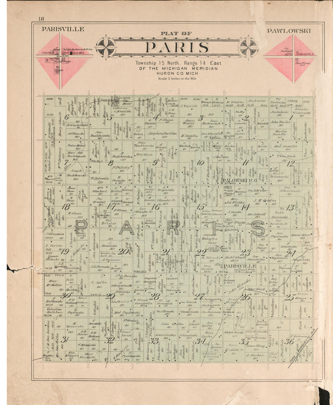 Paris from Plat Book of Huron County, Michigan : Also Patron's Business and General Farmer's Directory of Huron County, Mich. : With Biographical Sketches 1904Paris from Plat Book of Huron County, Michigan : Also Patron's Business and General Farmer's Directory of Huron County, Mich. : With Biographical Sketches 1904
- Regular price
-
$49.95 $83.95 - Regular price
-
$11.95 - Sale price
-
$49.95 $83.95
-
 Huron from Plat Book of Huron County, Michigan : Also Patron's Business and General Farmer's Directory of Huron County, Mich. : With Biographical Sketches 1904Huron from Plat Book of Huron County, Michigan : Also Patron's Business and General Farmer's Directory of Huron County, Mich. : With Biographical Sketches 1904
- Regular price
-
$49.95 $83.95 - Regular price
-
$11.95 - Sale price
-
$49.95 $83.95
-
 Biographies, P.18 from Plat Book of Huron County, Michigan : Also Patron's Business and General Farmer's Directory of Huron County, Mich. : With Biographical Sketches 1904Biographies, P.18 from Plat Book of Huron County, Michigan : Also Patron's Business and General Farmer's Directory of Huron County, Mich. : With Biographical Sketches 1904
- Regular price
-
$49.95 $83.95 - Regular price
-
$11.95 - Sale price
-
$49.95 $83.95
-
 Biographies, P.17 from Plat Book of Huron County, Michigan : Also Patron's Business and General Farmer's Directory of Huron County, Mich. : With Biographical Sketches 1904Biographies, P.17 from Plat Book of Huron County, Michigan : Also Patron's Business and General Farmer's Directory of Huron County, Mich. : With Biographical Sketches 1904
- Regular price
-
$49.95 $83.95 - Regular price
-
$11.95 - Sale price
-
$49.95 $83.95
-
 Sherman from Plat Book of Huron County, Michigan : Also Patron's Business and General Farmer's Directory of Huron County, Mich. : With Biographical Sketches 1904Sherman from Plat Book of Huron County, Michigan : Also Patron's Business and General Farmer's Directory of Huron County, Mich. : With Biographical Sketches 1904
- Regular price
-
$49.95 $83.95 - Regular price
-
$11.95 - Sale price
-
$49.95 $83.95
-
 Harbor Beach from Plat Book of Huron County, Michigan : Also Patron's Business and General Farmer's Directory of Huron County, Mich. : With Biographical Sketches 1904Harbor Beach from Plat Book of Huron County, Michigan : Also Patron's Business and General Farmer's Directory of Huron County, Mich. : With Biographical Sketches 1904
- Regular price
-
$49.95 $99.95 - Regular price
-
$21.95 - Sale price
-
$49.95 $99.95
-
 Caseville from Plat Book of Huron County, Michigan : Also Patron's Business and General Farmer's Directory of Huron County, Mich. : With Biographical Sketches 1904Caseville from Plat Book of Huron County, Michigan : Also Patron's Business and General Farmer's Directory of Huron County, Mich. : With Biographical Sketches 1904
- Regular price
-
$49.95 $83.95 - Regular price
-
$11.95 - Sale price
-
$49.95 $83.95
-
 Biographies, P.15 from Plat Book of Huron County, Michigan : Also Patron's Business and General Farmer's Directory of Huron County, Mich. : With Biographical Sketches 1904Biographies, P.15 from Plat Book of Huron County, Michigan : Also Patron's Business and General Farmer's Directory of Huron County, Mich. : With Biographical Sketches 1904
- Regular price
-
$49.95 $83.95 - Regular price
-
$11.95 - Sale price
-
$49.95 $83.95


