725 products
-
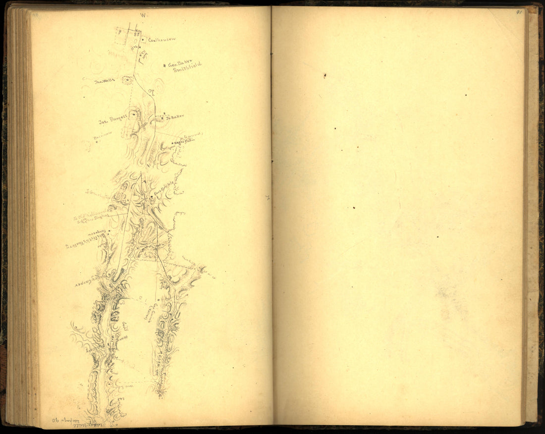 Image 100 of Sketch Book of Jed. Hotchkiss, Capt. & Top. Eng., Hd. Qrs., 2nd Corps, Army of N. Virginia : Virginia from Sketch Book of Jed. Hotchkiss, Capt. & Top. Eng., Hd. Qrs., 2nd Corps, Army of N. Virginia : Virginia 1862Image 100 of Sketch Book of Jed. Hotchkiss, Capt. & Top. Eng., Hd. Qrs., 2nd Corps, Army of N. Virginia : Virginia from Sketch Book of Jed. Hotchkiss, Capt. & Top. Eng., Hd. Qrs., 2nd Corps, Army of N. Virginia : Virginia 1862
- Regular price
-
$39.95 $83.95 - Regular price
-
$20.95 - Sale price
-
$39.95 $83.95
-
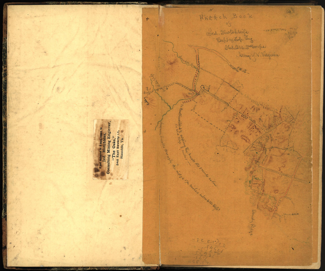 Image 4 of Sketch Book of Jed. Hotchkiss, Capt. & Top. Eng., Hd. Qrs., 2nd Corps, Army of N. Virginia : Virginia from Sketch Book of Jed. Hotchkiss, Capt. & Top. Eng., Hd. Qrs., 2nd Corps, Army of N. Virginia : Virginia 1862Image 4 of Sketch Book of Jed. Hotchkiss, Capt. & Top. Eng., Hd. Qrs., 2nd Corps, Army of N. Virginia : Virginia from Sketch Book of Jed. Hotchkiss, Capt. & Top. Eng., Hd. Qrs., 2nd Corps, Army of N. Virginia : Virginia 1862
- Regular price
-
$39.95 $83.95 - Regular price
-
$19.95 - Sale price
-
$39.95 $83.95
-
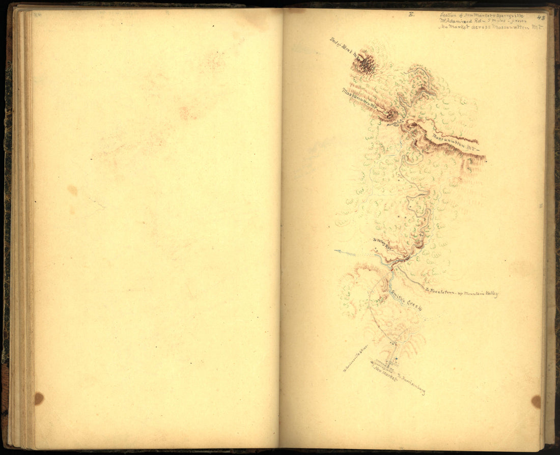 Image 51 of Sketch Book of Jed. Hotchkiss, Capt. & Top. Eng., Hd. Qrs., 2nd Corps, Army of N. Virginia : Virginia from Sketch Book of Jed. Hotchkiss, Capt. & Top. Eng., Hd. Qrs., 2nd Corps, Army of N. Virginia : Virginia 1862Image 51 of Sketch Book of Jed. Hotchkiss, Capt. & Top. Eng., Hd. Qrs., 2nd Corps, Army of N. Virginia : Virginia from Sketch Book of Jed. Hotchkiss, Capt. & Top. Eng., Hd. Qrs., 2nd Corps, Army of N. Virginia : Virginia 1862
- Regular price
-
$39.95 $83.95 - Regular price
-
$19.95 - Sale price
-
$39.95 $83.95
-
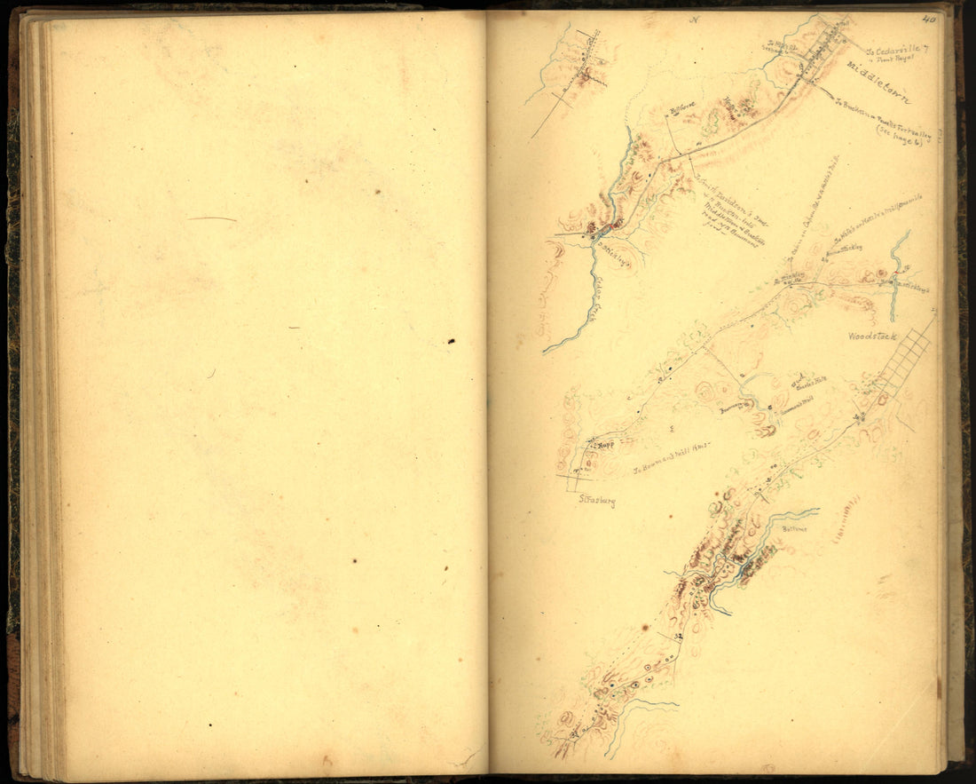 Image 48 of Sketch Book of Jed. Hotchkiss, Capt. & Top. Eng., Hd. Qrs., 2nd Corps, Army of N. Virginia : Virginia from Sketch Book of Jed. Hotchkiss, Capt. & Top. Eng., Hd. Qrs., 2nd Corps, Army of N. Virginia : Virginia 1862Image 48 of Sketch Book of Jed. Hotchkiss, Capt. & Top. Eng., Hd. Qrs., 2nd Corps, Army of N. Virginia : Virginia from Sketch Book of Jed. Hotchkiss, Capt. & Top. Eng., Hd. Qrs., 2nd Corps, Army of N. Virginia : Virginia 1862
- Regular price
-
$39.95 $83.95 - Regular price
-
$19.95 - Sale price
-
$39.95 $83.95
-
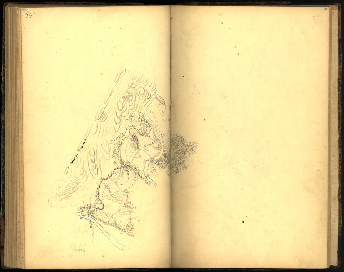 Image 104 of Sketch Book of Jed. Hotchkiss, Capt. & Top. Eng., Hd. Qrs., 2nd Corps, Army of N. Virginia : Virginia from Sketch Book of Jed. Hotchkiss, Capt. & Top. Eng., Hd. Qrs., 2nd Corps, Army of N. Virginia : Virginia 1862Image 104 of Sketch Book of Jed. Hotchkiss, Capt. & Top. Eng., Hd. Qrs., 2nd Corps, Army of N. Virginia : Virginia from Sketch Book of Jed. Hotchkiss, Capt. & Top. Eng., Hd. Qrs., 2nd Corps, Army of N. Virginia : Virginia 1862
- Regular price
-
$39.95 $83.95 - Regular price
-
$20.95 - Sale price
-
$39.95 $83.95
-
 Image 108 of Sketch Book of Jed. Hotchkiss, Capt. & Top. Eng., Hd. Qrs., 2nd Corps, Army of N. Virginia : Virginia from Sketch Book of Jed. Hotchkiss, Capt. & Top. Eng., Hd. Qrs., 2nd Corps, Army of N. Virginia : Virginia 1862Image 108 of Sketch Book of Jed. Hotchkiss, Capt. & Top. Eng., Hd. Qrs., 2nd Corps, Army of N. Virginia : Virginia from Sketch Book of Jed. Hotchkiss, Capt. & Top. Eng., Hd. Qrs., 2nd Corps, Army of N. Virginia : Virginia 1862
- Regular price
-
$39.95 $83.95 - Regular price
-
$20.95 - Sale price
-
$39.95 $83.95
-
 Image 79 of Sketch Book of Jed. Hotchkiss, Capt. & Top. Eng., Hd. Qrs., 2nd Corps, Army of N. Virginia : Virginia from Sketch Book of Jed. Hotchkiss, Capt. & Top. Eng., Hd. Qrs., 2nd Corps, Army of N. Virginia : Virginia 1862Image 79 of Sketch Book of Jed. Hotchkiss, Capt. & Top. Eng., Hd. Qrs., 2nd Corps, Army of N. Virginia : Virginia from Sketch Book of Jed. Hotchkiss, Capt. & Top. Eng., Hd. Qrs., 2nd Corps, Army of N. Virginia : Virginia 1862
- Regular price
-
$39.95 $83.95 - Regular price
-
$19.95 - Sale price
-
$39.95 $83.95
-
 Image 116 of Sketch Book of Jed. Hotchkiss, Capt. & Top. Eng., Hd. Qrs., 2nd Corps, Army of N. Virginia : Virginia from Sketch Book of Jed. Hotchkiss, Capt. & Top. Eng., Hd. Qrs., 2nd Corps, Army of N. Virginia : Virginia 1862Image 116 of Sketch Book of Jed. Hotchkiss, Capt. & Top. Eng., Hd. Qrs., 2nd Corps, Army of N. Virginia : Virginia from Sketch Book of Jed. Hotchkiss, Capt. & Top. Eng., Hd. Qrs., 2nd Corps, Army of N. Virginia : Virginia 1862
- Regular price
-
$39.95 $83.95 - Regular price
-
$20.95 - Sale price
-
$39.95 $83.95
-
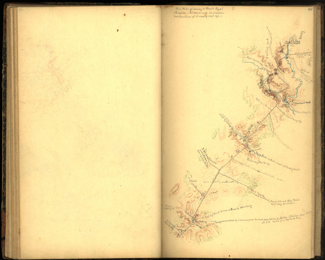 Image 56 of Sketch Book of Jed. Hotchkiss, Capt. & Top. Eng., Hd. Qrs., 2nd Corps, Army of N. Virginia : Virginia from Sketch Book of Jed. Hotchkiss, Capt. & Top. Eng., Hd. Qrs., 2nd Corps, Army of N. Virginia : Virginia 1862Image 56 of Sketch Book of Jed. Hotchkiss, Capt. & Top. Eng., Hd. Qrs., 2nd Corps, Army of N. Virginia : Virginia from Sketch Book of Jed. Hotchkiss, Capt. & Top. Eng., Hd. Qrs., 2nd Corps, Army of N. Virginia : Virginia 1862
- Regular price
-
$39.95 $83.95 - Regular price
-
$19.95 - Sale price
-
$39.95 $83.95
-
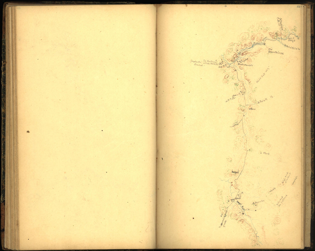 Image 60 of Sketch Book of Jed. Hotchkiss, Capt. & Top. Eng., Hd. Qrs., 2nd Corps, Army of N. Virginia : Virginia from Sketch Book of Jed. Hotchkiss, Capt. & Top. Eng., Hd. Qrs., 2nd Corps, Army of N. Virginia : Virginia 1862Image 60 of Sketch Book of Jed. Hotchkiss, Capt. & Top. Eng., Hd. Qrs., 2nd Corps, Army of N. Virginia : Virginia from Sketch Book of Jed. Hotchkiss, Capt. & Top. Eng., Hd. Qrs., 2nd Corps, Army of N. Virginia : Virginia 1862
- Regular price
-
$39.95 $83.95 - Regular price
-
$19.95 - Sale price
-
$39.95 $83.95
-
 Image 22 of Sketch Book of Jed. Hotchkiss, Capt. & Top. Eng., Hd. Qrs., 2nd Corps, Army of N. Virginia : Virginia from Sketch Book of Jed. Hotchkiss, Capt. & Top. Eng., Hd. Qrs., 2nd Corps, Army of N. Virginia : Virginia 1862Image 22 of Sketch Book of Jed. Hotchkiss, Capt. & Top. Eng., Hd. Qrs., 2nd Corps, Army of N. Virginia : Virginia from Sketch Book of Jed. Hotchkiss, Capt. & Top. Eng., Hd. Qrs., 2nd Corps, Army of N. Virginia : Virginia 1862
- Regular price
-
$39.95 $83.95 - Regular price
-
$18.95 - Sale price
-
$39.95 $83.95
-
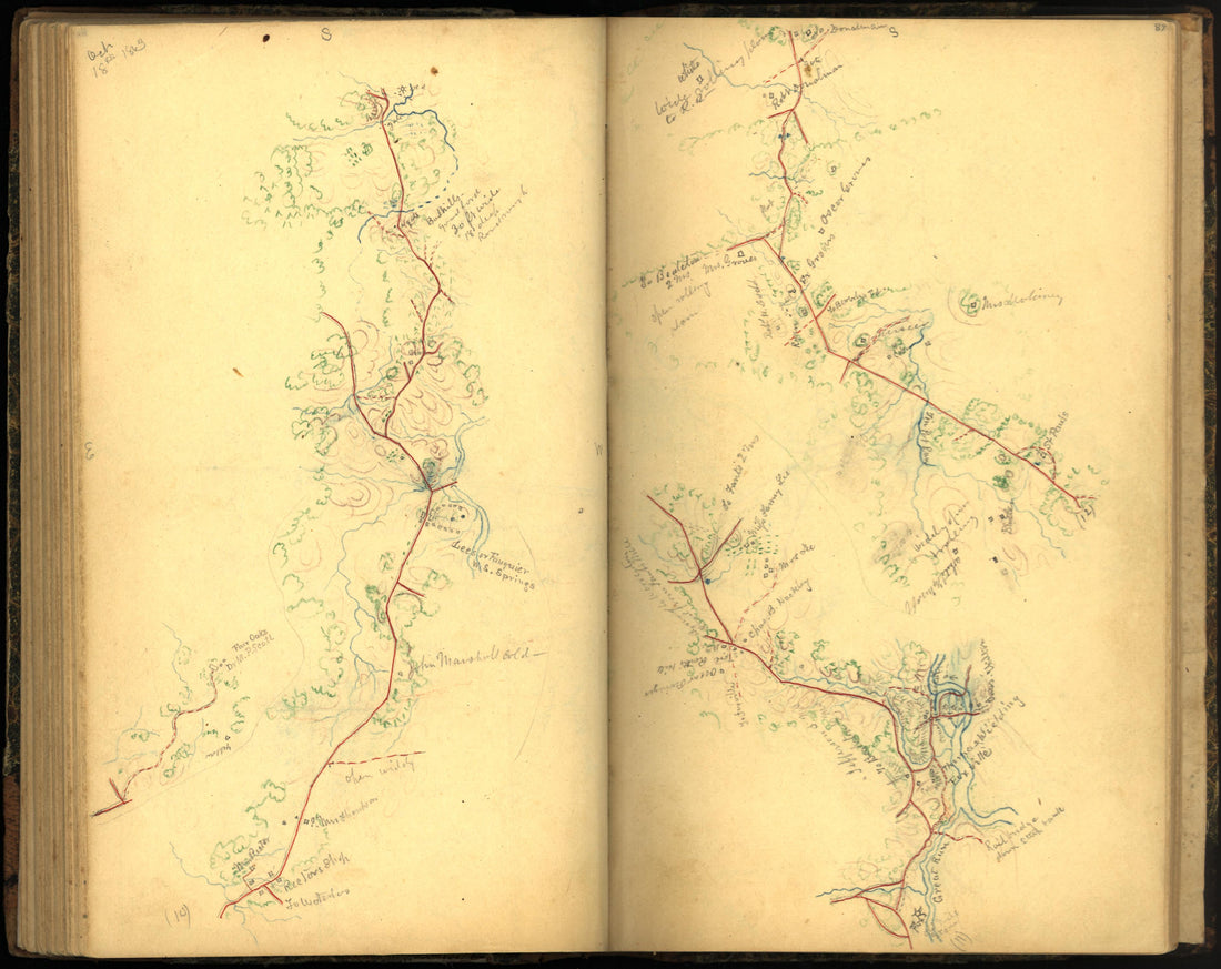 Image 96 of Sketch Book of Jed. Hotchkiss, Capt. & Top. Eng., Hd. Qrs., 2nd Corps, Army of N. Virginia : Virginia from Sketch Book of Jed. Hotchkiss, Capt. & Top. Eng., Hd. Qrs., 2nd Corps, Army of N. Virginia : Virginia 1862Image 96 of Sketch Book of Jed. Hotchkiss, Capt. & Top. Eng., Hd. Qrs., 2nd Corps, Army of N. Virginia : Virginia from Sketch Book of Jed. Hotchkiss, Capt. & Top. Eng., Hd. Qrs., 2nd Corps, Army of N. Virginia : Virginia 1862
- Regular price
-
$39.95 $83.95 - Regular price
-
$20.95 - Sale price
-
$39.95 $83.95


