1163 products
-
 Ancient, Medieval and Modern History - Continued from Standard Atlas of Buffalo and Pepin Counties, Wisconsin : Including a Plat Book of the Villages, Cities and Townships of the County, Map of the State, United States and World : Farmers … 1896Ancient, Medieval and Modern History - Continued from Standard Atlas of Buffalo and Pepin Counties, Wisconsin : Including a Plat Book of the Villages, Cities and Townships of the County, Map of the State, United States and World : Farmers … 1896
- Regular price
-
$49.95 $92.95 - Regular price
-
$36.95 - Sale price
-
$49.95 $92.95
-
 Portrait Department - Continued from Standard Atlas of Buffalo and Pepin Counties, Wisconsin : Including a Plat Book of the Villages, Cities and Townships of the County, Map of the State, United States and World : Farmers … 1896Portrait Department - Continued from Standard Atlas of Buffalo and Pepin Counties, Wisconsin : Including a Plat Book of the Villages, Cities and Townships of the County, Map of the State, United States and World : Farmers … 1896
- Regular price
-
$49.95 $92.95 - Regular price
-
$36.95 - Sale price
-
$49.95 $92.95
-
 Ancient, Medieval and Modern History - Continued from Standard Atlas of Buffalo and Pepin Counties, Wisconsin : Including a Plat Book of the Villages, Cities and Townships of the County, Map of the State, United States and World : Farmers … 1896Ancient, Medieval and Modern History - Continued from Standard Atlas of Buffalo and Pepin Counties, Wisconsin : Including a Plat Book of the Villages, Cities and Townships of the County, Map of the State, United States and World : Farmers … 1896
- Regular price
-
$49.95 $92.95 - Regular price
-
$36.95 - Sale price
-
$49.95 $92.95
-
 Map of Glencoe Buffalo County from Standard Atlas of Buffalo and Pepin Counties, Wisconsin : Including a Plat Book of the Villages, Cities and Townships of the County, Map of the State, United States and World : Farmers … 1896Map of Glencoe Buffalo County from Standard Atlas of Buffalo and Pepin Counties, Wisconsin : Including a Plat Book of the Villages, Cities and Townships of the County, Map of the State, United States and World : Farmers … 1896
- Regular price
-
$49.95 $92.95 - Regular price
-
$36.95 - Sale price
-
$49.95 $92.95
-
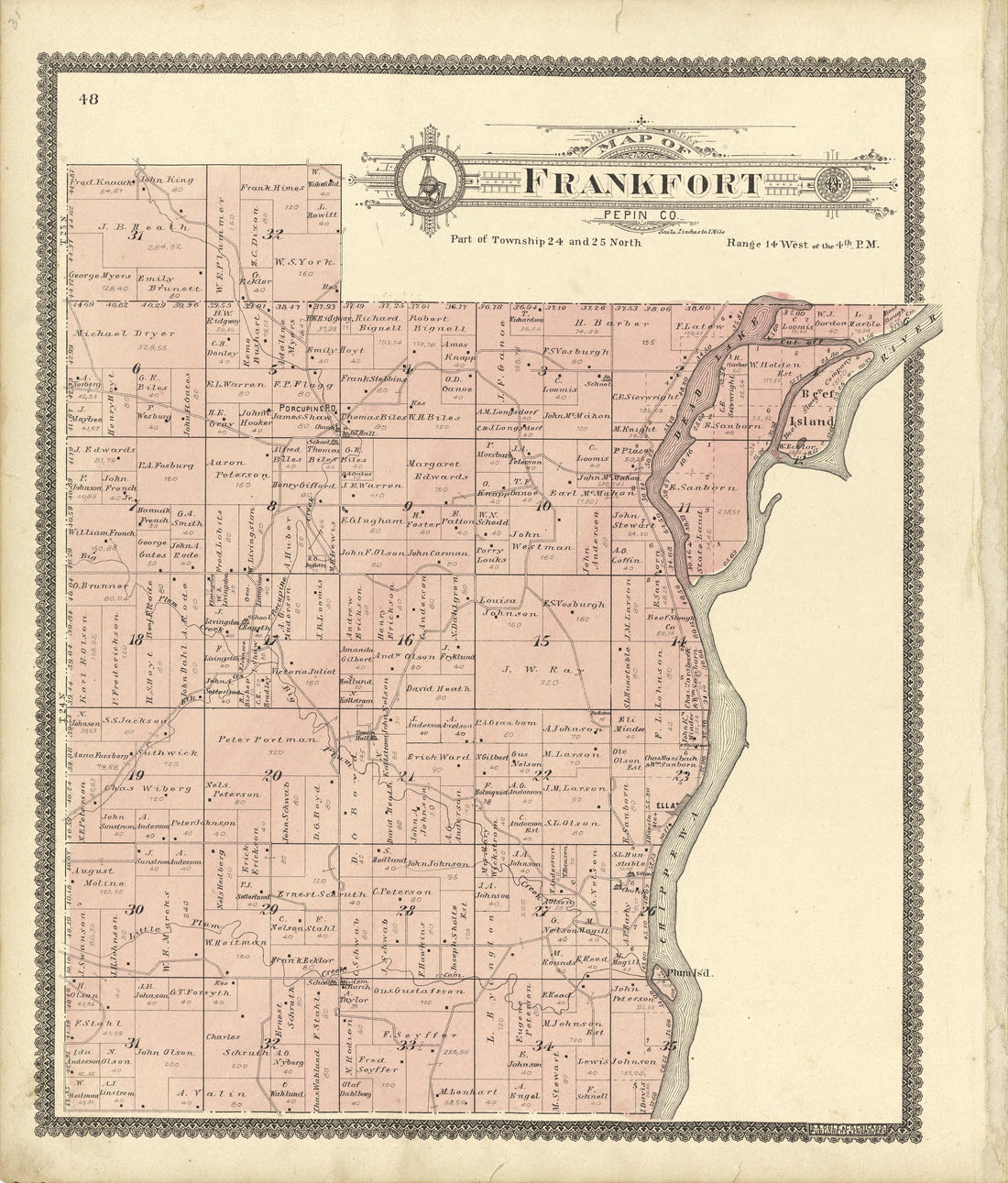 Map of Frankfort Pepin County from Standard Atlas of Buffalo and Pepin Counties, Wisconsin : Including a Plat Book of the Villages, Cities and Townships of the County, Map of the State, United States and World : Farmers … 1896Map of Frankfort Pepin County from Standard Atlas of Buffalo and Pepin Counties, Wisconsin : Including a Plat Book of the Villages, Cities and Townships of the County, Map of the State, United States and World : Farmers … 1896
- Regular price
-
$49.95 $93.95 - Regular price
-
$37.95 - Sale price
-
$49.95 $93.95
-
 Ancient, Medieval and Modern History - Continued from Standard Atlas of Buffalo and Pepin Counties, Wisconsin : Including a Plat Book of the Villages, Cities and Townships of the County, Map of the State, United States and World : Farmers … 1896Ancient, Medieval and Modern History - Continued from Standard Atlas of Buffalo and Pepin Counties, Wisconsin : Including a Plat Book of the Villages, Cities and Townships of the County, Map of the State, United States and World : Farmers … 1896
- Regular price
-
$49.95 $92.95 - Regular price
-
$36.95 - Sale price
-
$49.95 $92.95
-
 Map of Cross Buffalo County from Standard Atlas of Buffalo and Pepin Counties, Wisconsin : Including a Plat Book of the Villages, Cities and Townships of the County, Map of the State, United States and World : Farmers … 1896Map of Cross Buffalo County from Standard Atlas of Buffalo and Pepin Counties, Wisconsin : Including a Plat Book of the Villages, Cities and Townships of the County, Map of the State, United States and World : Farmers … 1896
- Regular price
-
$49.95 $92.95 - Regular price
-
$36.95 - Sale price
-
$49.95 $92.95
-
 Ancient, Medieval and Modern History - Continued from Standard Atlas of Buffalo and Pepin Counties, Wisconsin : Including a Plat Book of the Villages, Cities and Townships of the County, Map of the State, United States and World : Farmers … 1896Ancient, Medieval and Modern History - Continued from Standard Atlas of Buffalo and Pepin Counties, Wisconsin : Including a Plat Book of the Villages, Cities and Townships of the County, Map of the State, United States and World : Farmers … 1896
- Regular price
-
$49.95 $92.95 - Regular price
-
$36.95 - Sale price
-
$49.95 $92.95
-
 Map of Lima from Standard Atlas of Buffalo and Pepin Counties, Wisconsin : Including a Plat Book of the Villages, Cities and Townships of the County, Map of the State, United States and World : Farmers … 1896Map of Lima from Standard Atlas of Buffalo and Pepin Counties, Wisconsin : Including a Plat Book of the Villages, Cities and Townships of the County, Map of the State, United States and World : Farmers … 1896
- Regular price
-
$49.95 $92.95 - Regular price
-
$36.95 - Sale price
-
$49.95 $92.95
-
 Map of Pepin from Standard Atlas of Buffalo and Pepin Counties, Wisconsin : Including a Plat Book of the Villages, Cities and Townships of the County, Map of the State, United States and World : Farmers … 1896Map of Pepin from Standard Atlas of Buffalo and Pepin Counties, Wisconsin : Including a Plat Book of the Villages, Cities and Townships of the County, Map of the State, United States and World : Farmers … 1896
- Regular price
-
$49.95 $99.95 - Regular price
-
$36.95 - Sale price
-
$49.95 $99.95
-
 Ancient, Medieval and Modern History - Continued from Standard Atlas of Buffalo and Pepin Counties, Wisconsin : Including a Plat Book of the Villages, Cities and Townships of the County, Map of the State, United States and World : Farmers … 1896Ancient, Medieval and Modern History - Continued from Standard Atlas of Buffalo and Pepin Counties, Wisconsin : Including a Plat Book of the Villages, Cities and Townships of the County, Map of the State, United States and World : Farmers … 1896
- Regular price
-
$49.95 $92.95 - Regular price
-
$36.95 - Sale price
-
$49.95 $92.95


