Quick links
19716 products
-
Map of Whitfield County, Georgia in 1879
 Map of Whitfield County, Georgia in 1879
- Regular price
-
From
$32.95 - Regular price
-
$51.99 - Sale price
-
From
$32.95
-
Maps Showing the Location of the Boston & Worcester Rail Road : Copied from the Maps In the Offices of the Clerks of the County Commissioners In the Several Counties (Location of the Boston and Worcester Railroad 1835) 1858
 Maps Showing the Location of the Boston & Worcester Rail Road : Copied from the Maps In the Offices of the Clerks of the County Commissioners In the Several Counties (Location of the Boston and Worcester Railroad 1835) 1858
- Regular price
-
From
$41.95 - Regular price
-
$66.99 - Sale price
-
From
$41.95
-
Rand McNally New Official Railroad Map of the United States and Southern Canada in 1920
 Rand McNally New Official Railroad Map of the United States and Southern Canada in 1920
- Regular price
-
From
$32.95 - Regular price
-
$51.99 - Sale price
-
From
$32.95
-
Lloyd's Map of the Southern States Showing All the Railroads, Their Stations & Distances, Also the Counties, Towns, Villages, Harbors, Rivers, and Forts, Compiled from the Latest Government and Other Reliable Sources, 1862
 Lloyd's Map of the Southern States Showing All the Railroads, Their Stations & Distances, Also the Counties, Towns, Villages, Harbors, Rivers, and Forts, Compiled from the Latest Government and Other Reliable Sources, 1862
- Regular price
-
From
$32.95 - Regular price
-
$51.99 - Sale price
-
From
$32.95
-
Union Des Deux Ocʹeans Atlantique Et Pacifique, Par Le Transit Ouvert à Travers La Rʹepublique De Nicaragua : Carte Dʹetaillʹee Des Cinq Dʹepartements Avec Indication Des Principaux Tracʹes Du Canal Interocʹeanique in 1855
 Union Des Deux Ocʹeans Atlantique Et Pacifique, Par Le Transit Ouvert à Travers La Rʹepublique De Nicaragua : Carte Dʹetaillʹee Des Cinq Dʹepartements Avec Indication Des Principaux Tracʹes Du Canal Interocʹeanique in 1855
- Regular price
-
From
$41.95 - Regular price
-
$66.95 - Sale price
-
From
$41.95
-
Cedar Keys, Florida in 1861
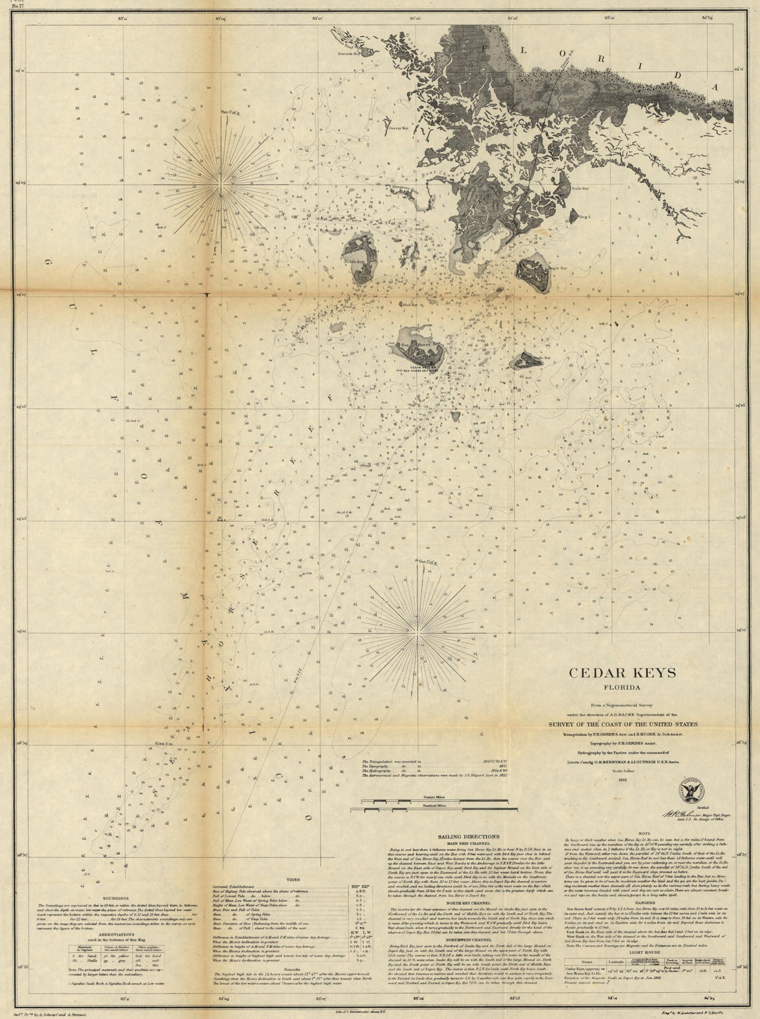 Cedar Keys, Florida in 1861
- Regular price
-
From
$32.95 - Regular price
-
$51.99 - Sale price
-
From
$32.95
-
Texas and Pacific Railway and Its Connections in 1876
 Texas and Pacific Railway and Its Connections in 1876
- Regular price
-
From
$41.95 - Regular price
-
$66.99 - Sale price
-
From
$41.95
-
A Geographically Correct County Map of the States Traversed by the Atchison Topeka and the Santa Fé Railroad and Its Connections in 1880
 A Geographically Correct County Map of the States Traversed by the Atchison Topeka and the Santa Fé Railroad and Its Connections in 1880
- Regular price
-
From
$41.95 - Regular price
-
$66.99 - Sale price
-
From
$41.95
-
Map of the City of Washington In the District of Columbia, U. States of America 1854
 Map of the City of Washington In the District of Columbia, U. States of America 1854
- Regular price
-
From
$22.95 - Regular price
-
$35.95 - Sale price
-
From
$22.95
-
Hydrographic Map of the Potomac River From Aqueduct Bridge, Georgetown, to Long Bridge, Washington, D.C in 1871
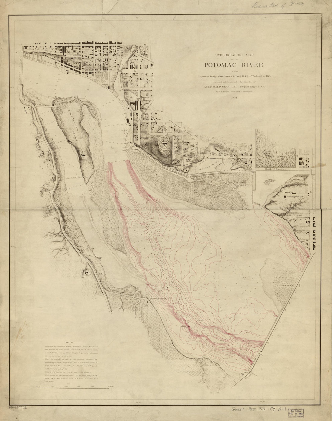 Hydrographic Map of the Potomac River From Aqueduct Bridge, Georgetown, to Long Bridge, Washington, D.C in 1871
- Regular price
-
From
$34.95 - Regular price
-
$49.99 - Sale price
-
From
$34.95
-
Map of the District of Columbia and Vicinity Showing the Principal Points of Interest Including the Present Condition of the Defenses of Washington 1892
 Map of the District of Columbia and Vicinity Showing the Principal Points of Interest Including the Present Condition of the Defenses of Washington 1892
- Regular price
-
From
$41.95 - Regular price
-
$66.99 - Sale price
-
From
$41.95
-
Chart of Broadway From Battery to 14th St in 1867
 Chart of Broadway From Battery to 14th St in 1867
- Regular price
-
From
$41.95 - Regular price
-
$66.95 - Sale price
-
From
$41.95


