Quick links
13434 products
-
Map of Part of Henrico and Chesterfield Counties, July 12th, 1862
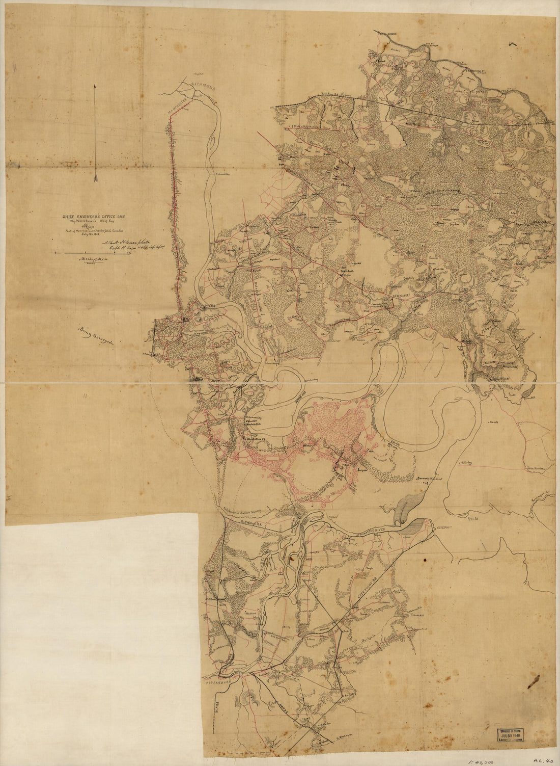 Map of Part of Henrico and Chesterfield Counties, July 12th, 1862
- Regular price
-
From
$32.95 - Regular price
-
$51.99 - Sale price
-
From
$32.95
-
War Telegram Marking Map 1862
 War Telegram Marking Map 1862
- Regular price
-
From
$41.95 - Regular price
-
$66.99 - Sale price
-
From
$41.95
-
Sketch of a Part of the Coast of Georgia from Savannah River to Ossabaw Sound Showing the Relative Positions of the U.S. Iron Clad Steamer Montauk & the Rebel Fort McAllister During the Bombardment of Feb 1st 1863
 Sketch of a Part of the Coast of Georgia from Savannah River to Ossabaw Sound Showing the Relative Positions of the U.S. Iron Clad Steamer Montauk & the Rebel Fort McAllister During the Bombardment of Feb 1st 1863
- Regular price
-
From
$19.95 - Regular price
-
$29.95 - Sale price
-
From
$19.95
-
Map Showing the Route of the Mobile & North Western Railroad, and Its Connections by Land and Sea; Henry Van Vleck Chief Engineer 1871
 Map Showing the Route of the Mobile & North Western Railroad, and Its Connections by Land and Sea; Henry Van Vleck Chief Engineer 1871
- Regular price
-
From
$32.95 - Regular price
-
$51.99 - Sale price
-
From
$32.95
-
Plan of the City of Washington 1798
 Plan of the City of Washington 1798
- Regular price
-
From
$19.95 - Regular price
-
$29.95 - Sale price
-
From
$19.95
-
Plat of Columbia Heights : Hon. John Sherman, Trustee 1882
 Plat of Columbia Heights : Hon. John Sherman, Trustee 1882
- Regular price
-
From
$32.95 - Regular price
-
$51.99 - Sale price
-
From
$32.95
-
Compendious Chart Exhibiting, at One View, the Names of About Thirteen Hundred of the Principal Ports and Places In the World, With Their Bearings Per Compass, and Their Distances Expressed In Geographical Miles, from the City of Washington 1827
 Compendious Chart Exhibiting, at One View, the Names of About Thirteen Hundred of the Principal Ports and Places In the World, With Their Bearings Per Compass, and Their Distances Expressed In Geographical Miles, from the City of Washington 1827
- Regular price
-
From
$32.95 - Regular price
-
$51.99 - Sale price
-
From
$32.95
-
District of Columbia--Virginia, Washington and Vicinity 1915
 District of Columbia--Virginia, Washington and Vicinity 1915
- Regular price
-
From
$34.95 - Regular price
-
$49.99 - Sale price
-
From
$34.95
-
Designs for Fortifying Governors Island Near New York 1766
 Designs for Fortifying Governors Island Near New York 1766
- Regular price
-
From
$19.95 - Regular price
-
$29.95 - Sale price
-
From
$19.95
-
Louisiana, As Formerly Claimed by France, Now Containing Part of British America to the East & Spanish America to the West of the Mississippi 1765
 Louisiana, As Formerly Claimed by France, Now Containing Part of British America to the East & Spanish America to the West of the Mississippi 1765
- Regular price
-
From
$32.95 - Regular price
-
$51.99 - Sale price
-
From
$32.95
-
Descripción De La Costa De La Luciana Y Entrada En El Río De Micisipi Con Sus Sondas Y Bajos, Nuebamente Correjido Y Enmendado Por Los Pilotos De La Real Armada En El Año De 1769
 Descripción De La Costa De La Luciana Y Entrada En El Río De Micisipi Con Sus Sondas Y Bajos, Nuebamente Correjido Y Enmendado Por Los Pilotos De La Real Armada En El Año De 1769
- Regular price
-
From
$29.95 - Regular price
-
$46.95 - Sale price
-
From
$29.95
-
A New and Accurate Map of the Provinces of Pensilvania, Virginia, Maryland and New Jersey 1762
 A New and Accurate Map of the Provinces of Pensilvania, Virginia, Maryland and New Jersey 1762
- Regular price
-
From
$19.95 - Regular price
-
$29.95 - Sale price
-
From
$19.95


