
Harrisburg, Mississippi 1912
- Regular price
-
$50.95 - Regular price
-
$45.95 - Sale price
-
$50.95
Buy one map, get any other map in our collection for 50% OFF! Add to cart to see discount.
Couldn't load pickup availability
About This Map
Discover the timeless beauty of our fine art quality printed reproduction of this antique map. Perfect for history enthusiasts, collectors, and interior decorators.
Restored with meticulous attention to detail by our team with over a decade of experience, this stunning reproduction captures the intricate artistry and historical significance of the original map.
Whether you're a collector or seeking a unique decor piece, this archival-quality map reproduction is a timeless addition to any space. Order now to bring history to life!
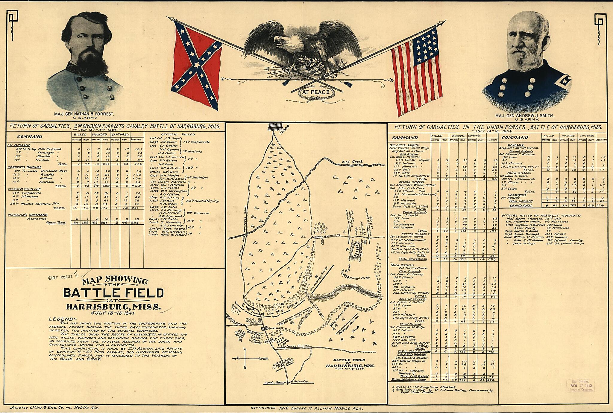
Old map of Harrisburg, Mississippi, United States.Created by Eugene H. Allman in 1912.
- Scale not given.
- Civil War Map
- "Legend: This map shows the position of the Confederate and the Federal forces during the three days encounter, showing in detail the position of the several commands.
- "The tables show the record of casualties, in offices [sic] and men, killed, wounded and captured during the three days, as compiled from the official records of the Union and Confederate armies, and is authentic.
- "This compilation is made by E. H. Allman, late private of Company "H"-6th Mississippi Cavalry, Gen. H. P. Mabry's command, Confederate forces, and is tendered to the veterans of the Blue and Gray."
- Indicates entrenchments, batteries, roads, towns, vegetation, drainage, and some relief by hachures. There are colored portraits of "Maj. Gen. Nathan B. Forrest, C.S. Army" and "Maj. Gen. Andrew J. Smith, U.S. Army" in the top margin, as well as a drawing of an eagle perched on the crossed flags of the Confederate States and United States with "at peace" printed below the flags.
- Description derived from published bibliography.
Map Subjects
Civil War
Harrisburg
Harrisburg (Miss.)
History
Mississippi
United States
Eugene H. Allman
1912
- For the best legibility, order your map in the original size or larger. Most maps have intricate detail and small text that is best appreciated when the print size hasn't been reduced.
- Sizes labeled "Fits a Standard Frame" will drop right into any frame that you purchase in that size. The sizes that we offer are commonly available online and at most retail stores.
- Our standard sizes are recommendations based on the aspect ratio of the original map, but still may require some added "white space" in one dimension to fit.
- Non-standard sizes will require custom framing, and we suggest taking your print to the frame shop of your choice after you receive it for the best results.
- Custom sizes are available, simply contact us for a quote.
Below is an approximation of the scale of a few standard sizes, and how they might appear in your space.
