
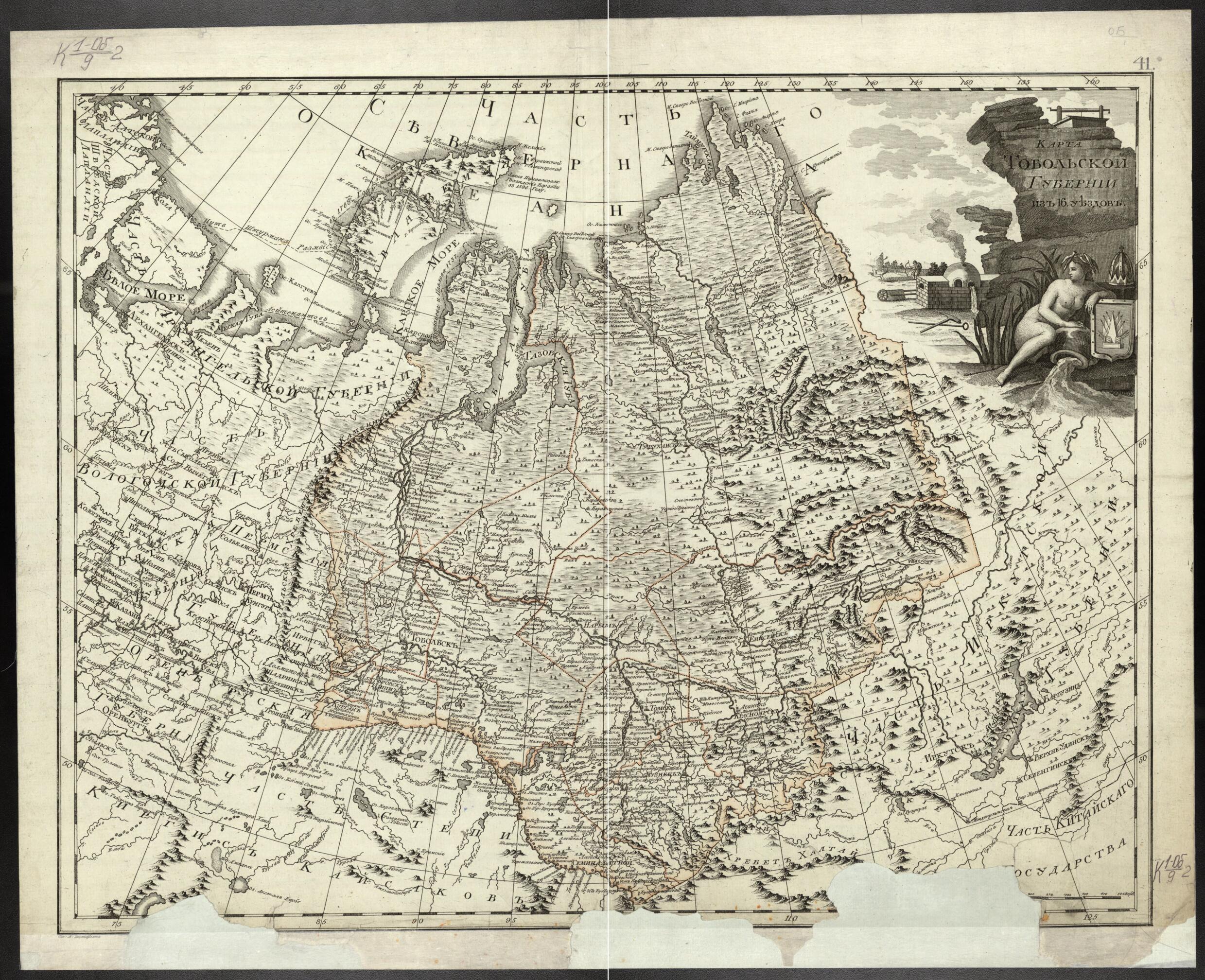
Karta Tobol'skoĭ Gubernii Iz 16 Uezdov. (Карта Тобольской губернии из 16 уездов.) 1800
- Regular price
-
$62.95 - Regular price
-
$57.95 - Sale price
-
$62.95
Buy one map, get any other map in our collection for 50% OFF! Add to cart to see discount.
Couldn't load pickup availability
About This Map
Discover the timeless beauty of our fine art quality printed reproduction of this antique map. Perfect for history enthusiasts, collectors, and interior decorators.
Restored with meticulous attention to detail by our team with over a decade of experience, this stunning reproduction captures the intricate artistry and historical significance of the original map.
Whether you're a collector or seeking a unique decor piece, this archival-quality map reproduction is a timeless addition to any space. Order now to bring history to life!
Old map of Russian Federation, Tyumen Oblast.an allegorical symbol of the Ob' River. The creator of the map, A.M. Vilbrekht, was a geographer in the Geographical Department of the Cabinet of Her Imperial Majesty, established during the reign of Catherine the Great. The cabinet produced a major work, Rossiiskii atlas iz soroka trekh kart sostoiashchii i na sorok odnu guberniiu Imperiiu razdeliaiushchii (Russian atlas comprising 43 maps and dividing the empire into 41 provinces), from which this map is taken. World Digital Library.
Created by Alexander Wilbrecht in 1800.
- Karta iz izdanii︠a︡: Rossiĭskiĭ atlas iz soroka trekh kart sostoi︠a︡shchiĭ i na sorok odnu gubernii︠u︡ Imperii︠u︡ razdeli︠a︡i︠u︡shchiĭ.
- Pokazany: granit︠s︡a Tobol'skoĭ gubernii i ee uezdov, naselennye punkty, monastyri, zimov'i︠a︡,kreposti, priiski, soli︠a︡nye i rybnye promysly, marshruty plavaniĭ Malygina (1734, 1735), Skuratova (1734, 1735), Ovt︠s︡yna (1735), Murav'eva (1737), Pavlova (1737), Rozmyslova (1768), mesto zimovki gollandskikh korableĭ v 1596. Zaglavie v khudozhestvennom kartushe s risunkom st︠s︡eny okhoty, simvolov gornozavodskogo proizvodstva, allegorii reki Ob' - devy s urnoĭ.
- Original map at: National Library of Russia
- Карта из издания: Российский атлас из сорока трех карт состоящий и на сорок одну губернию Империю разделяющий.
- Показаны: граница Тобольской губернии и ее уездов, населенные пункты, монастыри, зимовья,крепости, прииски, соляные и рыбные промыслы, маршруты плаваний Малыгина (1734, 1735), Скуратова (1734, 1735), Овцына (1735), Муравьева (1737), Павлова (1737), Розмыслова (1768), место зимовки голландских кораблей в 1596. Заглавие в художественном картуше с рисунком сцены охоты, символов горнозаводского производства, аллегории реки Обь - девы с урной.
- For the best legibility, order your map in the original size or larger. Most maps have intricate detail and small text that is best appreciated when the print size hasn't been reduced.
- Sizes labeled "Fits a Standard Frame" will drop right into any frame that you purchase in that size. The sizes that we offer are commonly available online and at most retail stores.
- Our standard sizes are recommendations based on the aspect ratio of the original map, but still may require some added "white space" in one dimension to fit.
- Non-standard sizes will require custom framing, and we suggest taking your print to the frame shop of your choice after you receive it for the best results.
- Custom sizes are available, simply contact us for a quote.
Below is an approximation of the scale of a few standard sizes, and how they might appear in your space.

