
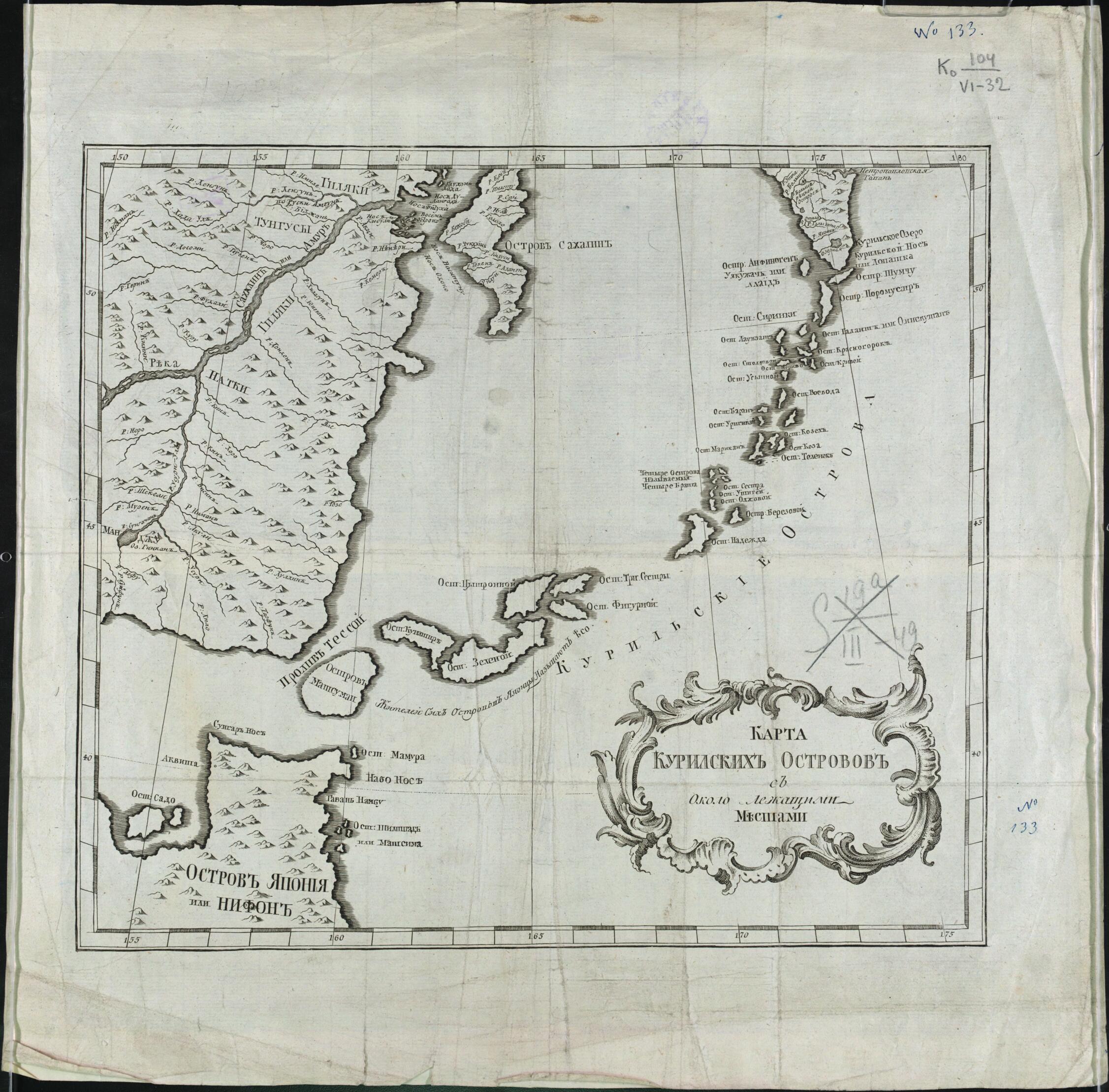
Karta Kuril'skikh Ostrovov S Okolo Lezhashchimi Mestami. (Карта Курильских островов с около лежащими местами.) 1700
- Regular price
-
$54.95 - Regular price
-
$38.95 - Sale price
-
$54.95
Buy one map, get any other map in our collection for 50% OFF! Add to cart to see discount.
Couldn't load pickup availability
About This Map
Discover the timeless beauty of our fine art quality printed reproduction of this antique map. Perfect for history enthusiasts, collectors, and interior decorators.
Restored with meticulous attention to detail by our team with over a decade of experience, this stunning reproduction captures the intricate artistry and historical significance of the original map.
Whether you're a collector or seeking a unique decor piece, this archival-quality map reproduction is a timeless addition to any space. Order now to bring history to life!
Old map of Kuril Islands, Russian Federation, Sakhalin Oblast.day Hierro), the westernmost of the Canary Islands (the western edge of the world known to the ancients), used by geographers back to the time of Ptolemy as a base point prior to the agreement in 1884 that the prime meridian would run through Greenwich, England. World Digital Library.
- Na karte pokazany krupnye i melkie ostrova Kuril'skoĭ gri︠a︡dy, chast' ostrova I︠A︡ponii︠a︡ ili Nifon; ostrov Sakhalin. Zaglavie karty pomeshcheno v kartushi.
- Setka geograficheskikh koordinat. Dolgota ot Ferro.
- Original map at: Russian State Library
- На карте показаны крупные и мелкие острова Курильской гряды, часть острова Япония или Нифон; остров Сахалин. Заглавие карты помещено в картуши.
- Сетка географических координат. Долгота от Ферро.
- For the best legibility, order your map in the original size or larger. Most maps have intricate detail and small text that is best appreciated when the print size hasn't been reduced.
- Sizes labeled "Fits a Standard Frame" will drop right into any frame that you purchase in that size. The sizes that we offer are commonly available online and at most retail stores.
- Our standard sizes are recommendations based on the aspect ratio of the original map, but still may require some added "white space" in one dimension to fit.
- Non-standard sizes will require custom framing, and we suggest taking your print to the frame shop of your choice after you receive it for the best results.
- Custom sizes are available, simply contact us for a quote.
Below is an approximation of the scale of a few standard sizes, and how they might appear in your space.

