
Karta Baĭkala, Mori︠a︡, Ozera Ili Angarskago Provala, V Irkutskoĭ Guberniĭ Sostoi︠a︡shchago So Vsi︠e︡mi Ego Okryzhnosti︠a︡mi, Kotoriĭ Matematicheskim Izmi︠e︡reniem Okonchan I Priveden V Sovershennui︠u︡ Izvi︠e︡stnost' V ...
- Regular price
-
$54.95 - Regular price
-
$38.95 - Sale price
-
$54.95
Buy one map, get any other map in our collection for 50% OFF! Add to cart to see discount.
Couldn't load pickup availability
About This Map
Discover the timeless beauty of our fine art quality printed reproduction of this antique map. Perfect for history enthusiasts, collectors, and interior decorators.
Restored with meticulous attention to detail by our team with over a decade of experience, this stunning reproduction captures the intricate artistry and historical significance of the original map.
Whether you're a collector or seeking a unique decor piece, this archival-quality map reproduction is a timeless addition to any space. Order now to bring history to life!
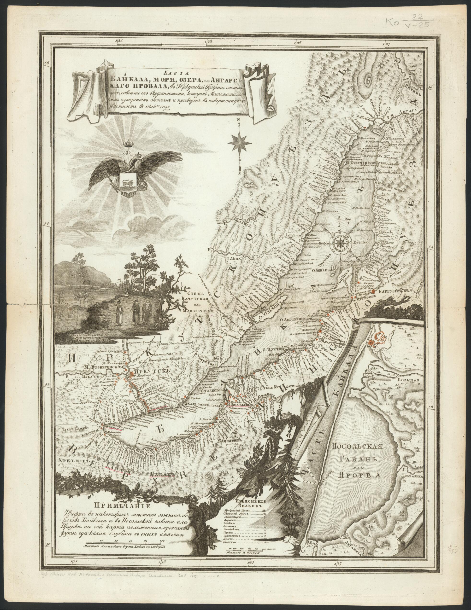
Old map of Irkutsk Oblast, Russian Federation.headed eagle, holding in its talons the coat of arms of Irkutsk Province. The illustration at the lower left is a view of Nikolaevsk Pier, located at the point where the Angara River flows from the lake. The enlarged map in the lower right-hand corner depicts Ambassador's Harbor or "Prorva." The numbers indicate soundings of depth in feet. The map uses perspective to show hills and mountains. Lake Baikal is the deepest lake in the world. Its volume of water is approximately equal to the total volume of the Great Lakes of North America, or to about 20 per cent of all freshwater on the earth. World Digital Library.
- Zaglavie v kartushe. Pod nim izobrazhen odnoglavyĭ orel, derzhashchiĭ v kogti︠a︡kh gerb Irkutskoĭ gubernii. Nizhe pomeshchen vid Nikolavskoĭ pristani pri istechenii Angaru iz Baĭkala. V pravom nizhnem uglu v uvelichennom masshtabe - Posol'skai︠a︡ gavan' ili Prorva, t︠s︡iframi pokazany promery glubin v funtakh. Gornyĭ rel'ef na karte izobrazhen perespektivno kholmikami. Podrobno dana rechnai︠a︡ set' i beregovai︠a︡ linii︠a︡ ozera.
- Original map at: Russian State Library
- Заглавие в картуше. Под ним изображен одноглавый орел, держащий в когтях герб Иркутской губернии. Ниже помещен вид Николавской пристани при истечении Ангару из Байкала. В правом нижнем углу в увеличенном масштабе - Посольская гавань или Прорва, цифрами показаны промеры глубин в фунтах. Горный рельеф на карте изображен переспективно холмиками. Подробно дана речная сеть и береговая линия озера.
- For the best legibility, order your map in the original size or larger. Most maps have intricate detail and small text that is best appreciated when the print size hasn't been reduced.
- Sizes labeled "Fits a Standard Frame" will drop right into any frame that you purchase in that size. The sizes that we offer are commonly available online and at most retail stores.
- Our standard sizes are recommendations based on the aspect ratio of the original map, but still may require some added "white space" in one dimension to fit.
- Non-standard sizes will require custom framing, and we suggest taking your print to the frame shop of your choice after you receive it for the best results.
- Custom sizes are available, simply contact us for a quote.
Below is an approximation of the scale of a few standard sizes, and how they might appear in your space.

