
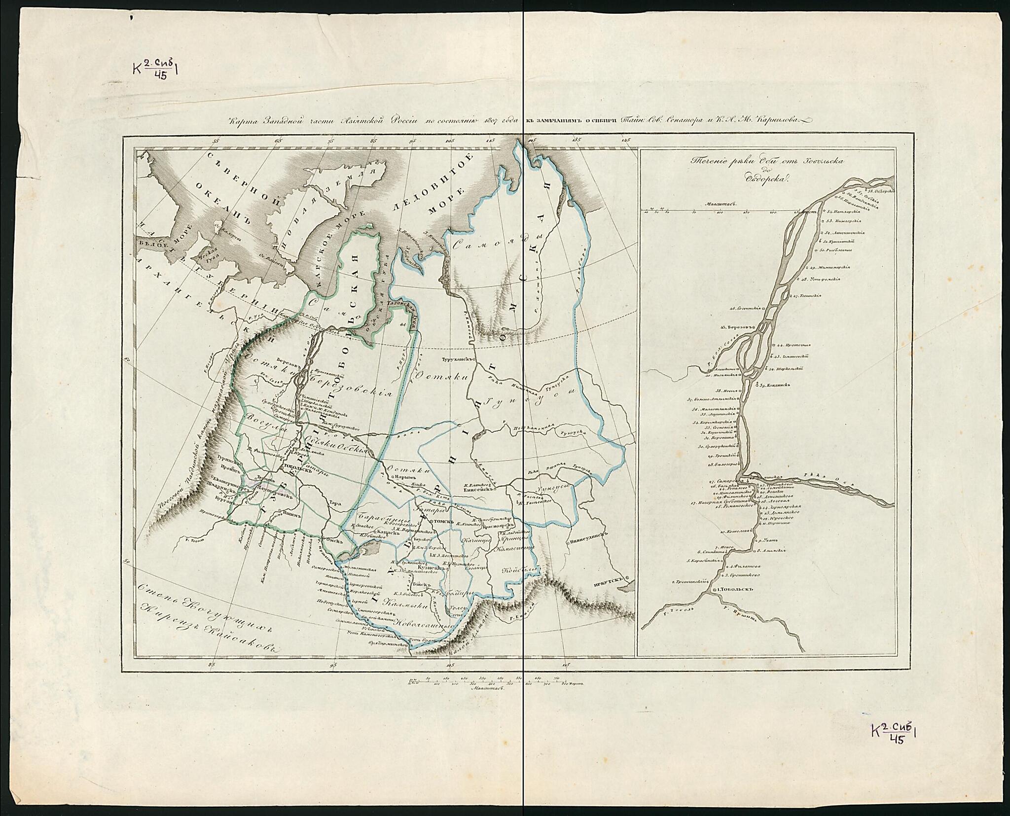
Karta Zapadnoĭ Chasti Aziatskoĭ Rossii Po Sostoi︠a︡nii︠u︡ 1807 G. I Zamechanii︠a︡m O Sibiri Taĭnogo Sovetnika Senatora M. Kornilova. (Карта Западной Части Азиатской России по Состоянию 1807 г...
- Regular price
-
$54.95 - Regular price
-
$33.95 - Sale price
-
$54.95
Buy one map, get any other map in our collection for 50% OFF! Add to cart to see discount.
Couldn't load pickup availability
About This Map
Discover the timeless beauty of our fine art quality printed reproduction of this antique map. Perfect for history enthusiasts, collectors, and interior decorators.
Restored with meticulous attention to detail by our team with over a decade of experience, this stunning reproduction captures the intricate artistry and historical significance of the original map.
Whether you're a collector or seeking a unique decor piece, this archival-quality map reproduction is a timeless addition to any space. Order now to bring history to life!
Old map of Irkutsk Oblast, Novosibirsk Oblast, Omsk Oblast, Russian Federation, Tomsk Oblast, Tyumen Oblast.This map depicts the western part of Asiatic Russia and includes the territory stretching from Ekaterinburg to Irkutsk (approximately 3,500 kilometers). Besides rivers, mountains, and cities, it shows settlements of different ethnic groups: Tungus, Ostyak, Kalmyk, and many others. The map incorporates remarks made by Alexei Kornilov, a governor of Irkutsk Province, then Tobol'sk Province, and later a senator. His notes, compiled in 1807, include information about the ethnic diversity of Irkutsk and Tobol'sk provinces, means of transportation, systems of government, and other topics. The right side of the map depicts part of the Ob' River flowing from the west and turning north at its confluence with the Irtysh River. Numerous towns are located along both of these rivers, ranging from Tobol'sk in the south to Obdorsk (renamed Salekhard in 1933) in the north. The Ob' is one of the great rivers of Asia, flowing north and west across western Siberia in a twisting path from its source in the Altai Mountains to its outlet at the Gulf of Ob' into the Kara Sea. World Digital Library.
- Pokazany: administrativnye granit︠s︡y, naselennye punkty (3gr.); rel'ef shtrikhami. Dop. karty: Techenie reki Obi ot Tobol'ska do Obdorska.
- Original map at: National Library of Russia
- Показаны: административные границы, населенные пункты (3гр.); рельеф штрихами. Доп. карты: Течение реки Оби от Тобольска до Обдорска.
Map Subjects
Irkutsk Oblast
Novosibirsk Oblast
Omsk Oblast
Russian Federation
Siberia
Tomsk Oblast
Tyumen Oblast
1807
- For the best legibility, order your map in the original size or larger. Most maps have intricate detail and small text that is best appreciated when the print size hasn't been reduced.
- Sizes labeled "Fits a Standard Frame" will drop right into any frame that you purchase in that size. The sizes that we offer are commonly available online and at most retail stores.
- Our standard sizes are recommendations based on the aspect ratio of the original map, but still may require some added "white space" in one dimension to fit.
- Non-standard sizes will require custom framing, and we suggest taking your print to the frame shop of your choice after you receive it for the best results.
- Custom sizes are available, simply contact us for a quote.
Below is an approximation of the scale of a few standard sizes, and how they might appear in your space.

