
Plany Kuril'skikh Ostrovov. (Планы Курильских островов.) 1811
- Regular price
-
$53.95 - Regular price
-
$37.95 - Sale price
-
$53.95
Shipping calculated at checkout.
Buy one map, get any other map in our collection for 50% OFF! Add to cart to see discount.
Couldn't load pickup availability
About This Map
Old map of Kuril Islands, Russian Federation, Sakhalin Oblast.
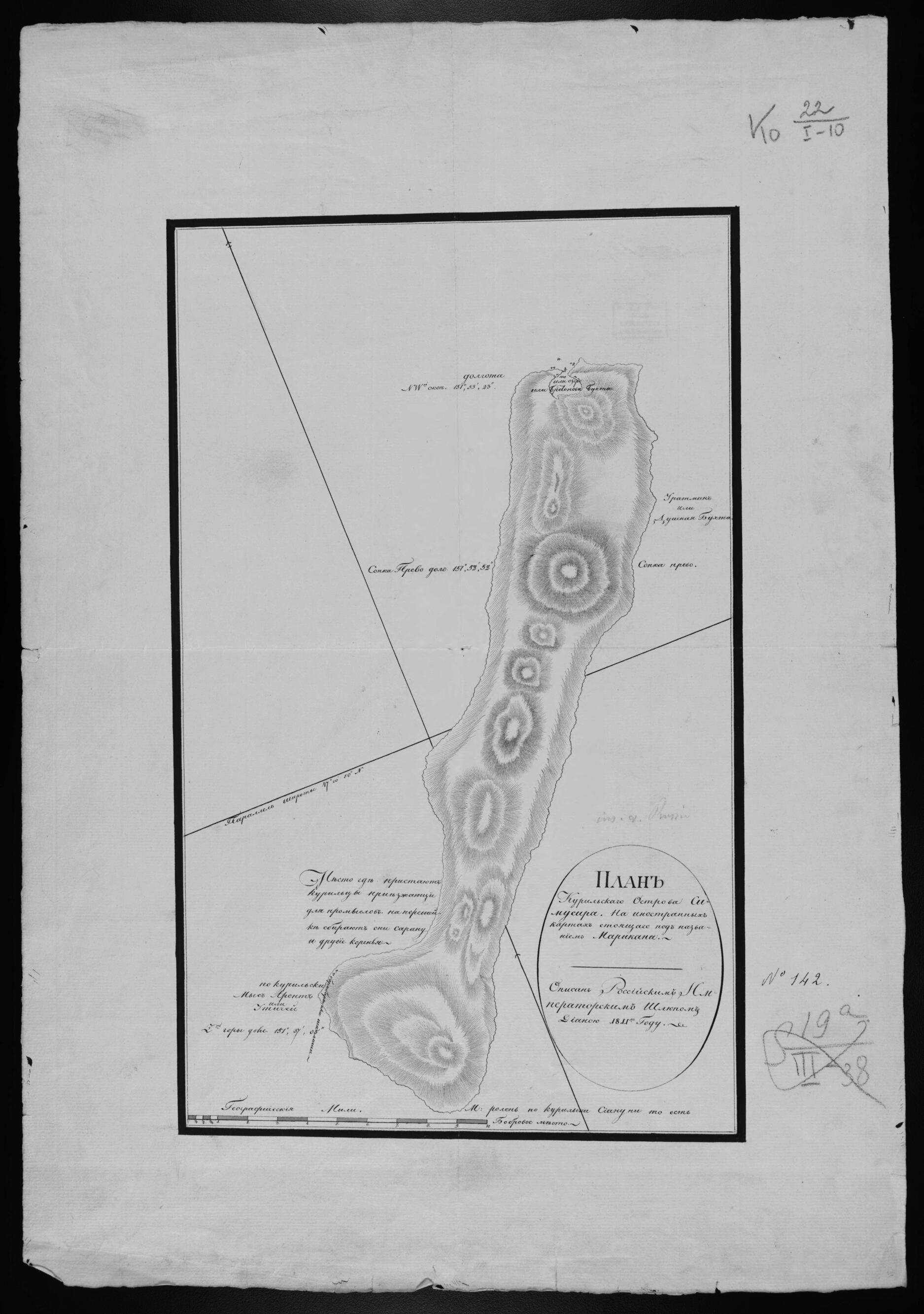
1838), a long-time official of the Russian-American Company, for use as a cartographic and navigational resource for company needs. The charts were drawn on the famous Russian sloop Diana, which visited the Kurile Islands in 1811 under orders of the Imperial Russian Naval Ministry. The Diana's mission was to explore and map the southern part of the island chain as well as other sites in the North Pacific. These charts focus on the island of Simushir Ostrov (labelled as Marikan, an earlier name, on international maps). They reference the presence of sea otters, the furs of which were the main business interest of the Russian-American Company. Locations on the island where Kurile natives pursued traditional activities, including the gathering of roots, are also highlighted. The presence of large volcanoes on this island, as throughout the entire Kurile chain, is apparent from the stark relief shown on the charts by hachures and shading. Latitude and longitude are provided, including longitudinal readings (from Greenwich, England) for several volcanic peaks. A scale at the bottom of the map indicates distance in geographical miles. A geographical mile represents a unit of length equal to one minute of arc on the Earth's equator; thus 60 geographical miles are contained within one degree of longitude at the equator, with precise mathematical variations occurring by latitude to the poles. World Digital Library.
Created by K. T. (Kiril Timofeevich) Khlebnikov in 1811.
- Opisanie Rossiĭskogo imperatorskogo shli︠u︡pa Diany shturmanom 9 klassa K. T. Khlebnikovym. Rukopisnye listy planov, sostavlennykh K. T. Khlebnikovym, kotoryĭ s 1801 goda sluzhil v Russkoĭ-Amerikanskoĭ kompanii, a s 1816 po 1833 gg. upravli︠a︡l vladenii︠a︡mi Russko-Amerikanskoĭ kompanii. Na planakh izobrazheniĭ ostrova ili gruppy ostrovov, kotorye chetko vyrisovany. Vulkanicheskoe proiskhozhdenie ostrovov vidno iz-za shtrikhovogo izobrazhenii︠a︡ rel'efa.
- Original map at: Russian State Library
- Описание Российского императорского шлюпа Дианы штурманом 9 класса К. Т. Хлебниковым. Рукописные листы планов, составленных К. Т. Хлебниковым, который с 1801 года служил в Русской-Американской компании, а с 1816 по 1833 гг. управлял владениями Русско-Американской компании. На планах изображений острова или группы островов, которые четко вырисованы. Вулканическое происхождение островов видно из-за штрихового изображения рельефа.
Map Sizing Information
- For the best legibility, order your map in the original size or larger. Most maps have intricate detail and small text that is best appreciated when the print size hasn't been reduced.
- Sizes labeled "Fits a Standard Frame" will drop right into any frame that you purchase in that size. The sizes that we offer are commonly available online and at most retail stores.
- Our standard sizes are recommendations based on the aspect ratio of the original map, but still may require some added "white space" in one dimension to fit.
- Non-standard sizes will require custom framing, and we suggest taking your print to the frame shop of your choice after you receive it for the best results.
- Custom sizes are available, simply contact us for a quote.
Below is an approximation of the scale of a few standard sizes, and how they might appear in your space.

