
Vostochnoĭ Chasti Sibiri K Puteshestvii︠u︡ Leĭtenanta Barona Vrangeli︠a︡, V 1820, 21, 22 I 23 Godakh. (восточной части Сибири к путешествию лейтенанта барона Врангеля, в 1820, 21, 22 �...
- Regular price
-
$51.95 - Regular price
-
$35.95 - Sale price
-
$51.95
Buy one map, get any other map in our collection for 50% OFF! Add to cart to see discount.
Couldn't load pickup availability
About This Map
Discover the timeless beauty of our fine art quality printed reproduction of this antique map. Perfect for history enthusiasts, collectors, and interior decorators.
Restored with meticulous attention to detail by our team with over a decade of experience, this stunning reproduction captures the intricate artistry and historical significance of the original map.
Whether you're a collector or seeking a unique decor piece, this archival-quality map reproduction is a timeless addition to any space. Order now to bring history to life!
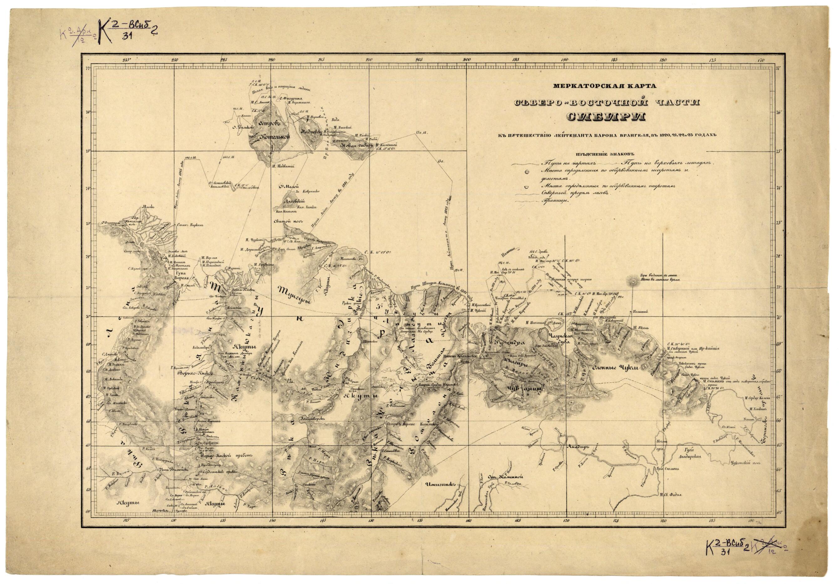
Old map of Russian Federation.- Cherno-belai︠a︡. Iz [Atlasa k puteshestvii︠u︡ Vrangeli︠a︡], 1841.Kartograficheskai︠a︡ setka po dolgote cherez 10°, s vykhodom koordinat cherez 5°, po shirote cherez 5°, s vykhodom koordinat cherez 1°; schet dolgot ot Grinvicha.
- Uslovnye znaki: put' na nartakh, put' na verkhovykh loshadi︠a︡kh, mesta, opredelennye po shirotam i dolgotam, severnyĭ predel lesov, granit︠s︡a. Pokazany: naselennye punkty (na puti sledovanii︠a︡ ėkspedit︠s︡ii, s datoĭ stoi︠a︡nok v nikh), mesta stoi︠a︡nok ėkspedit︠s︡ii Vrangeli︠a︡, mar.
- Original map at: National Library of Russia
- Черно-белая. Из [Атласа к путешествию Врангеля], 1841.Картографическая сетка по долготе через 10°, с выходом координат через 5°, по широте через 5°, с выходом координат через 1°; счет долгот от Гринвича.
- Условные знаки: путь на нартах, путь на верховых лошадях, места, определенные по широтам и долготам, северный предел лесов, граница. Показаны: населенные пункты (на пути следования экспедиции, с датой стоянок в них), места стоянок экспедиции Врангеля, мар.
- For the best legibility, order your map in the original size or larger. Most maps have intricate detail and small text that is best appreciated when the print size hasn't been reduced.
- Sizes labeled "Fits a Standard Frame" will drop right into any frame that you purchase in that size. The sizes that we offer are commonly available online and at most retail stores.
- Our standard sizes are recommendations based on the aspect ratio of the original map, but still may require some added "white space" in one dimension to fit.
- Non-standard sizes will require custom framing, and we suggest taking your print to the frame shop of your choice after you receive it for the best results.
- Custom sizes are available, simply contact us for a quote.
Below is an approximation of the scale of a few standard sizes, and how they might appear in your space.
