
Vostochnym Beregom Azii, Mezhdu Mysami Oli︠u︡torskim I Chukotskim. Sni︠a︡ta S Karty Kapitana Litke, Dopolnena Opis'i︠u︡ Anadyrskoĭ Guby, Proizvedennoĭ V 1847 G. Na Sudakh Rossiĭskoĭ-Amerikanskoĭ Kompanii ... 1849. (восточным ...
- Regular price
-
$110.95 - Regular price
-
$105.95 - Sale price
-
$110.95
Buy one map, get any other map in our collection for 50% OFF! Add to cart to see discount.
Couldn't load pickup availability
About This Map
Discover the timeless beauty of our fine art quality printed reproduction of this antique map. Perfect for history enthusiasts, collectors, and interior decorators.
Restored with meticulous attention to detail by our team with over a decade of experience, this stunning reproduction captures the intricate artistry and historical significance of the original map.
Whether you're a collector or seeking a unique decor piece, this archival-quality map reproduction is a timeless addition to any space. Order now to bring history to life!
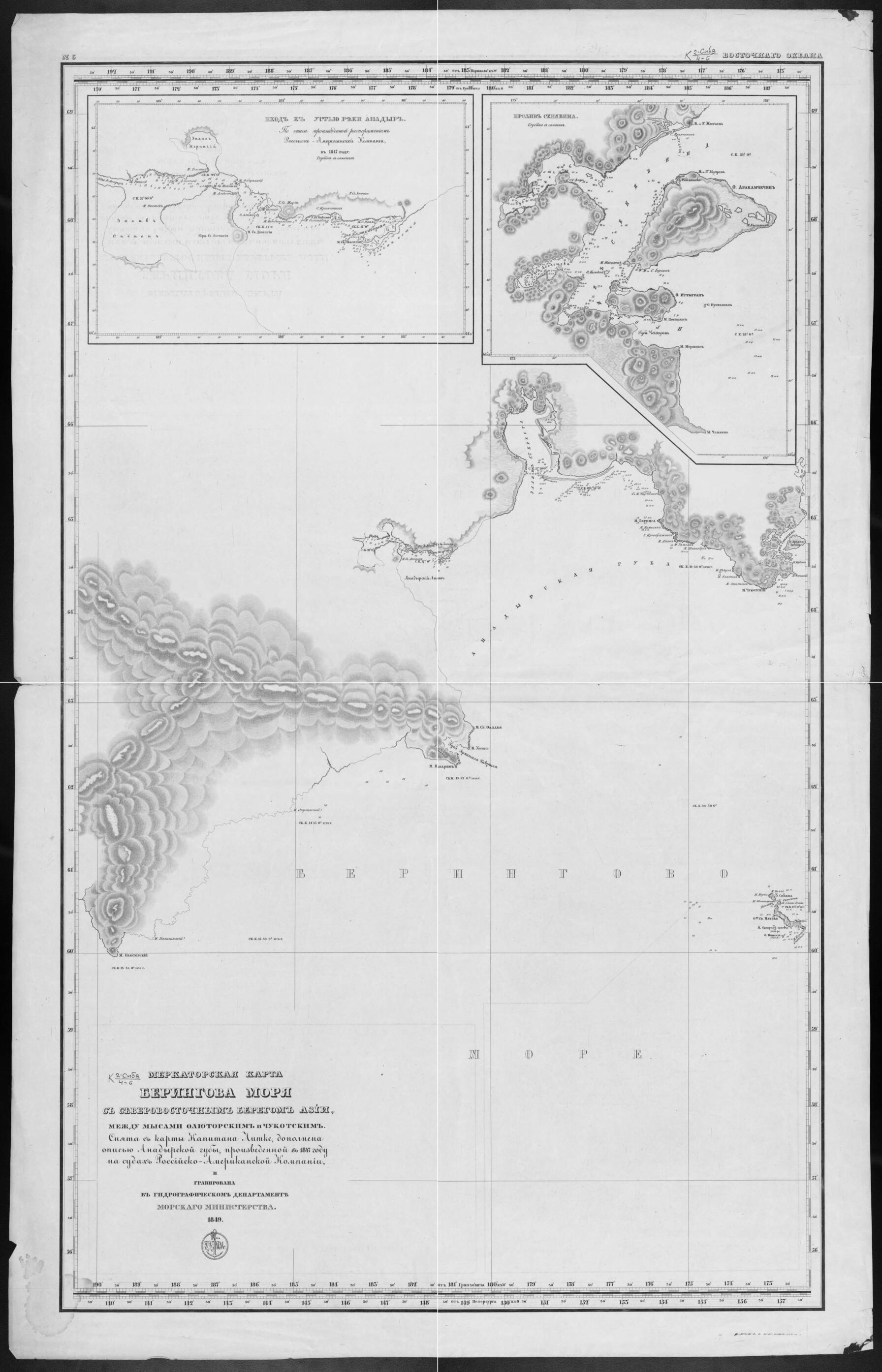
Old map of Chukotka Autonomous Okrug, Russian Federation.29, as captain of the ship Seniavin, he completed his second circumnavigation of the world. On this voyage, he mapped the western coastline of the Bering Sea. He subsequently published, in French and Russian, an eight-volume account of his explorations that included numerous maps and plans. This mid-19th-century Russian map, produced by the Ministry of Marine, is based on one of Litke's maps. It shows sandbars, notations of depth in sazhens, and anchorages. Relief is shown by shading, and notations of height are given in feet. The supplemental maps at the top are of the mouth of the Anadyr' River and the Seniavin Strait. World Digital Library.
Created by Hydrographic Department of the Ministry of Marine, Fedor Petrovich Litke in 1849.
- Pokazany: otmeli, otmetki glubin v sazheni︠a︡kh i kharakter dna, i︠a︡kornye mesta; rel'ef shtrikhami, otmetki vysot v futakh. Dop. karty: 1. Vkhod k ust'i︠u︡ reki Anadyr'. 2. Proliv Seni︠a︡vina.
- Original map at: National Library of Russia
- Показаны: отмели, отметки глубин в саженях и характер дна, якорные места; рельеф штрихами, отметки высот в футах. Доп. карты: 1. Вход к устью реки Анадырь. 2. Пролив Сенявина.
- For the best legibility, order your map in the original size or larger. Most maps have intricate detail and small text that is best appreciated when the print size hasn't been reduced.
- Sizes labeled "Fits a Standard Frame" will drop right into any frame that you purchase in that size. The sizes that we offer are commonly available online and at most retail stores.
- Our standard sizes are recommendations based on the aspect ratio of the original map, but still may require some added "white space" in one dimension to fit.
- Non-standard sizes will require custom framing, and we suggest taking your print to the frame shop of your choice after you receive it for the best results.
- Custom sizes are available, simply contact us for a quote.
Below is an approximation of the scale of a few standard sizes, and how they might appear in your space.

