
Karta Amurskoĭ Strany S Pokazaniem Semok, Marshrutov I Opiseĭ, Proizvedennykh S 1850 Po 1860 God. (Карта Амурской страны с показанием съемок, маршрутов и описей, произведенных с 1850 ...
- Regular price
-
$58.95 - Regular price
-
$41.95 - Sale price
-
$58.95
Buy one map, get any other map in our collection for 50% OFF! Add to cart to see discount.
Couldn't load pickup availability
About This Map
Discover the timeless beauty of our fine art quality printed reproduction of this antique map. Perfect for history enthusiasts, collectors, and interior decorators.
Restored with meticulous attention to detail by our team with over a decade of experience, this stunning reproduction captures the intricate artistry and historical significance of the original map.
Whether you're a collector or seeking a unique decor piece, this archival-quality map reproduction is a timeless addition to any space. Order now to bring history to life!
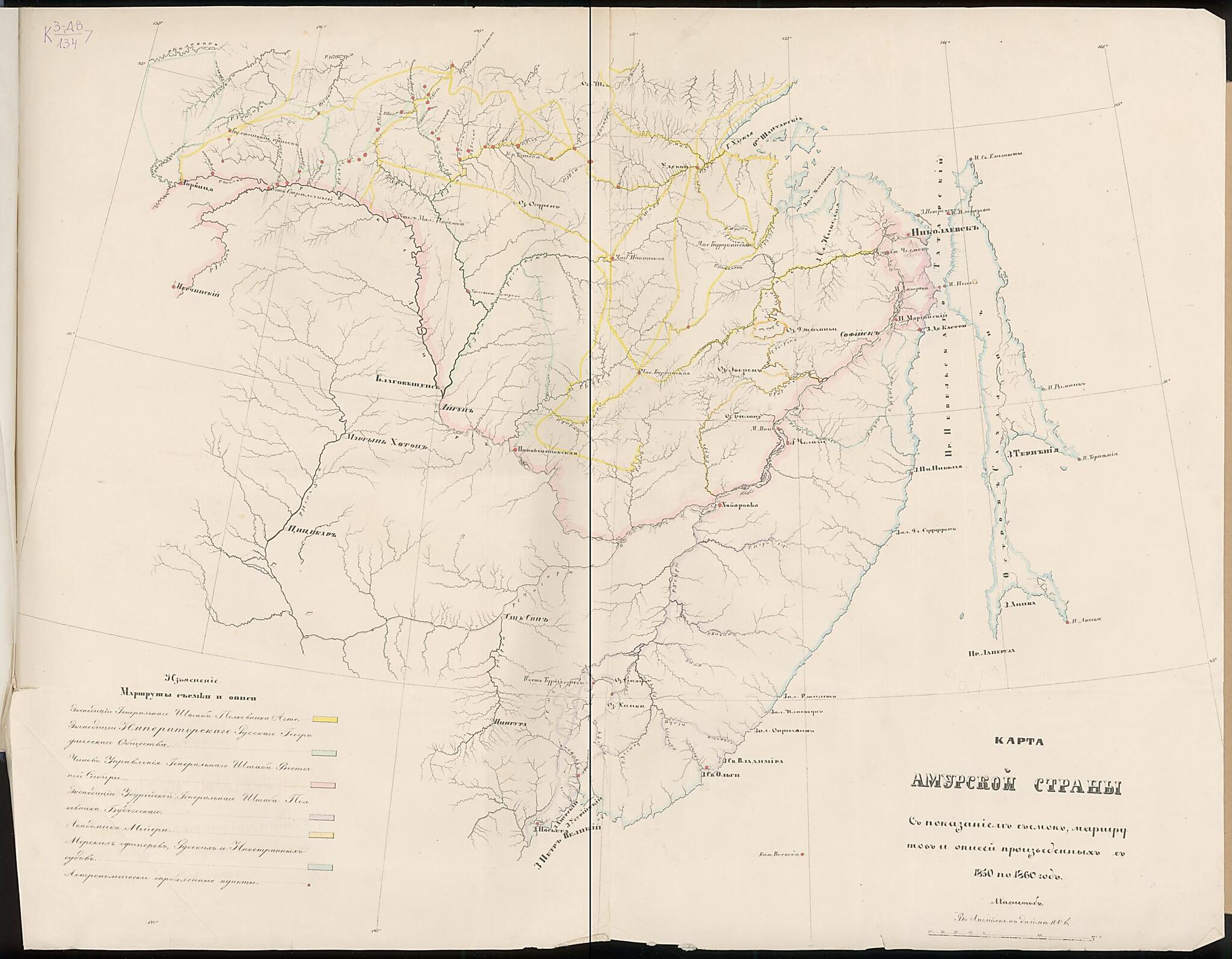
Old map of Amur Oblast, Khabarovsk Krai, Russian Federation.60, each marked by a different color identified in the legend at the lower left. In this period, Russia conducted rigorous and extensive explorations of the Far East to create maps, gain knowledge about mineral deposits, and demarcate the border with China. The expedition led by Gennadii Nevelskoi made some of the most important discoveries, including confirming that the Amur was navigable along its entire length and that Sakhalin is an island. In August 1850, Nevelskoi founded Nikolaevskii Post (present-day Nikolaevsk-on-Amur) at the head of the Amur River estuary as an outpost on the Pacific. As depicted on the map, the strait between the mainland and Sakhalin Island was named after Nevelskoi (present-day Strait of Tartary). The Amur is the longest river in the Russian Far East and defines the border between Russia and northeastern China. World Digital Library.
- Pokazano: marshruty ėkspedit︠s︡iĭ, astronomicheskie punkty. S poi︠a︡snitel'noĭ zapiskoĭ.
- Original map at: National Library of Russia
- Показано: маршруты экспедиций, астрономические пункты. С пояснительной запиской.
Map Subjects
Amur Oblast
Khabarovsk Krai
Russian Federation
1860
- For the best legibility, order your map in the original size or larger. Most maps have intricate detail and small text that is best appreciated when the print size hasn't been reduced.
- Sizes labeled "Fits a Standard Frame" will drop right into any frame that you purchase in that size. The sizes that we offer are commonly available online and at most retail stores.
- Our standard sizes are recommendations based on the aspect ratio of the original map, but still may require some added "white space" in one dimension to fit.
- Non-standard sizes will require custom framing, and we suggest taking your print to the frame shop of your choice after you receive it for the best results.
- Custom sizes are available, simply contact us for a quote.
Below is an approximation of the scale of a few standard sizes, and how they might appear in your space.

