
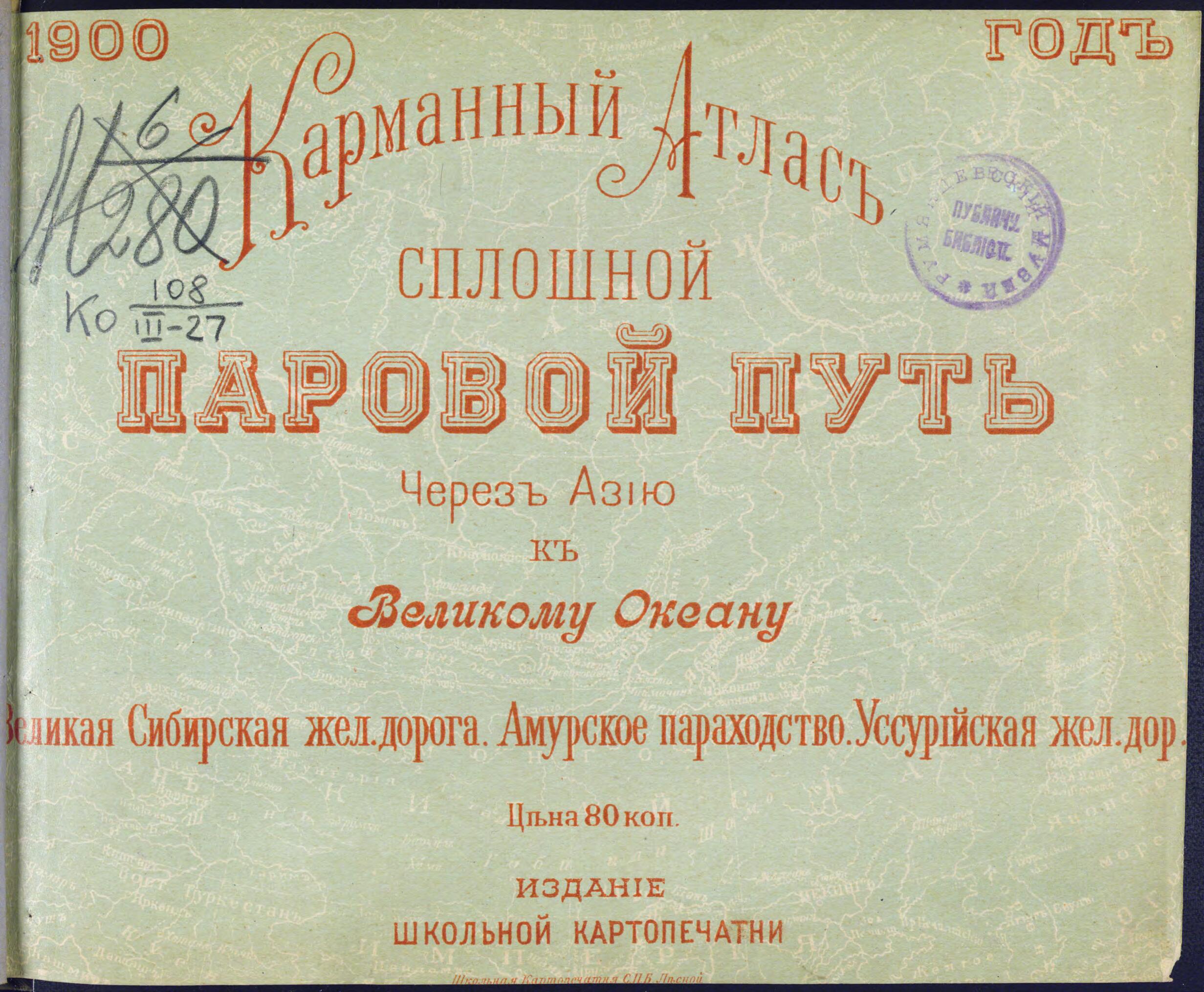
Karmannyĭ Atlas. Sploshnoĭ Parovoĭ Put' Cherez Azii︠u︡ K Velikomu Okeanu. Velikai︠a︡ Sibirskai︠a︡ Zheleznai︠a︡ Doroga. Amurskoe Parokhodstvo. Ussuriĭskai︠a︡ Zheleznai︠a︡ Doroga. (Карманный Атлас. Сплошн�...
- Regular price
-
$49.95 - Regular price
-
$34.95 - Sale price
-
$49.95
Buy one map, get any other map in our collection for 50% OFF! Add to cart to see discount.
Couldn't load pickup availability
About This Map
Discover the timeless beauty of our fine art quality printed reproduction of this antique map. Perfect for history enthusiasts, collectors, and interior decorators.
Restored with meticulous attention to detail by our team with over a decade of experience, this stunning reproduction captures the intricate artistry and historical significance of the original map.
Whether you're a collector or seeking a unique decor piece, this archival-quality map reproduction is a timeless addition to any space. Order now to bring history to life!
Old map of Amur Oblast, Blagoveshchensk, Buryatia, China, Chita, Irkutsk, Irkutsk Oblast, Krasnoyarsk, Krasnoyarsk Krai, Liaoning Province, Primorskiy Krai, Republic of, Russian Federation, Tomsk, Tomsk Oblast, Vladivostok, Zabaykalsky Krai.Siberian Railroad, the Ussuri Railroad, and the Amur River steamship lines. The publication reflects Russian national pride in the recent establishment of transit links to the Pacific Ocean, even before all sections of the Trans-Siberian Railroad were complete. The atlas contains 27 maps and 14 photographs. The first map shows the global network of rail and steamship connections. It is followed by a general map of Asiatic Russia (Siberia) and a map of the Trans-Siberian Railroad as far as Irkutsk (the route to Vladivostok was unfinished as of 1900, especially the arduous mountain route along the southern tip of Lake Baikal). Other maps show the southern shores of Lake Baikal; the Trans-Baikal Railroad; the Amur steamship routes and the Ussuri Railroad; the Kwantung region (the southern part of Liaodong Peninsula in China, a territorial concession occupied by Russia in 1898); with Dalian and Port Arthur and their environs. Separate maps show some of the largest Siberian and Russian Far Eastern cities and their environs, including Tomsk, Irkutsk, Krasnoyarsk, Chita, Blagoveshchensk, and Vladivostok. Interspersed with the maps are photographs of Siberian scenes, depicting railroad stations, steamship wharves, and vistas of places shown on the accompanying maps. World Digital Library.
- Original map at: Russian State Library
- For the best legibility, order your map in the original size or larger. Most maps have intricate detail and small text that is best appreciated when the print size hasn't been reduced.
- Sizes labeled "Fits a Standard Frame" will drop right into any frame that you purchase in that size. The sizes that we offer are commonly available online and at most retail stores.
- Our standard sizes are recommendations based on the aspect ratio of the original map, but still may require some added "white space" in one dimension to fit.
- Non-standard sizes will require custom framing, and we suggest taking your print to the frame shop of your choice after you receive it for the best results.
- Custom sizes are available, simply contact us for a quote.
Below is an approximation of the scale of a few standard sizes, and how they might appear in your space.

