
Karta Poluostrova I︠A︡mal. Vnutrenni︠a︡i︠a︡ Oblast' Poluostrova Sostavlena Po Sëmkam ėkspedit︠s︡ii Imperatorskogo Russkogo Geograficheskogo Obshchestva 1908 G. Pod Nachal'stvom B.M. Zhitkova. (Карта полуострова Яма...
- Regular price
-
$136.95 - Regular price
-
$131.95 - Sale price
-
$136.95
Buy one map, get any other map in our collection for 50% OFF! Add to cart to see discount.
Couldn't load pickup availability
About This Map
Discover the timeless beauty of our fine art quality printed reproduction of this antique map. Perfect for history enthusiasts, collectors, and interior decorators.
Restored with meticulous attention to detail by our team with over a decade of experience, this stunning reproduction captures the intricate artistry and historical significance of the original map.
Whether you're a collector or seeking a unique decor piece, this archival-quality map reproduction is a timeless addition to any space. Order now to bring history to life!
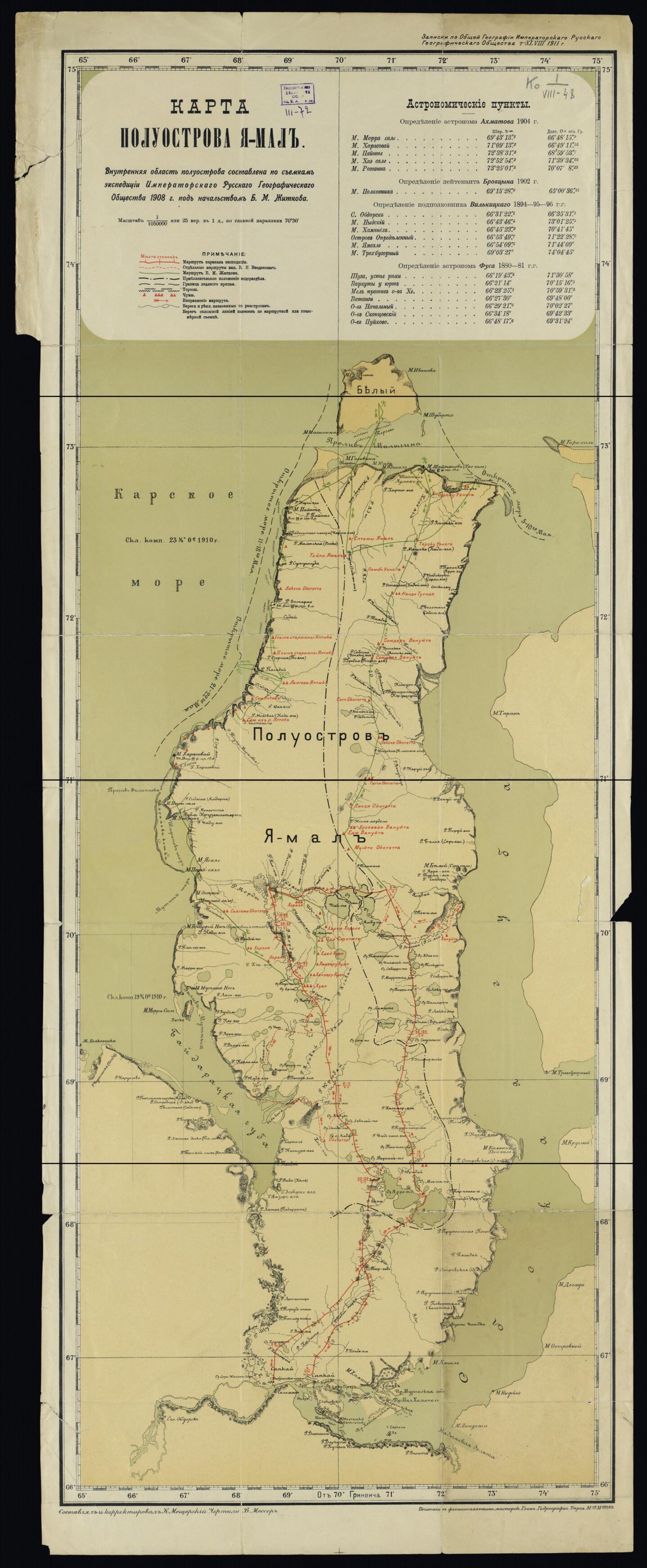
Old map of Nenetskiy Autonomous Okrug, Russian Federation, Yamalo.1943), a prominent zoologist and ornithologist who taught vertebrate zoology at Moscow State University. Zhitkov conducted numerous expeditions to the Arctic and adjoining regions, stretching as far east as the Commander Islands in the Bering Sea. He published a book about the Yamal Peninsula following his trip and was an early advocate for wildlife conservation. Prior to the arrival of the Russians, the Nenets and Khanty (Ostyak) people had occupied the Yamal Peninsula for millennia and traditional nomadic reindeer husbandry was long the backbone of the native economy and way of life. Russian--and later Soviet--expeditions came to map this Arctic region and to survey its extensive natural resources. The map highlights the main route of the 1908 expedition under the leadership of Zhitkov (solid green line), a supplemental route under the command of Vadim Nikolaevich Vvedenskii (dashed red line), and the expedition's supply route (solid red line, with stopping points). Other references are to rivers, lakes and other bodies of water, settlements, and the extent of the ice pack. Relief is indicated by shading and hachures. The peninsula is shown bordered by the Kara Sea, Gulf of Ob, and Baydaratskaya Bay. The map was compiled and corrected by K. Meshcherskii and drawn by B. Messer. It was printed by the Main Hydrographic Administration of the Russian government. Various measurements of latitude and longitude on the Yamal Peninsula, confirmed by astronomical observations, are listed in the map legend. World Digital Library.
Created by Imperial Russian Geographical Society, K. Meshcherskiĭ, B. Messer in 1911.
- Na karte naneseny marshrut karavana ėspedit︠s︡ii, marshrut V.M. Zhitkova , otdel'nye marshruty kapitana V.N. Vvedenskogo. Imeetsi︠a︡ tablit︠s︡a astronomicheskikh punktov s tochnymi koordinatami.
- Interior of the peninsula composed according to the surveys of the 1908 expedition of the Imperial Russian Geographic Society under B.M. Zhitkov.
- Original map at: Russian State Library
- На карте нанесены маршрут каравана эспедиции, маршрут В.М. Житкова , отдельные маршруты капитана В.Н. Введенского. Имеется таблица астрономических пунктов с точными координатами.
- Interior of the peninsula composed according to the surveys of the 1908 expedition of the Imperial Russian Geographic Society under B.M. Zhitkov.
- For the best legibility, order your map in the original size or larger. Most maps have intricate detail and small text that is best appreciated when the print size hasn't been reduced.
- Sizes labeled "Fits a Standard Frame" will drop right into any frame that you purchase in that size. The sizes that we offer are commonly available online and at most retail stores.
- Our standard sizes are recommendations based on the aspect ratio of the original map, but still may require some added "white space" in one dimension to fit.
- Non-standard sizes will require custom framing, and we suggest taking your print to the frame shop of your choice after you receive it for the best results.
- Custom sizes are available, simply contact us for a quote.
Below is an approximation of the scale of a few standard sizes, and how they might appear in your space.

