
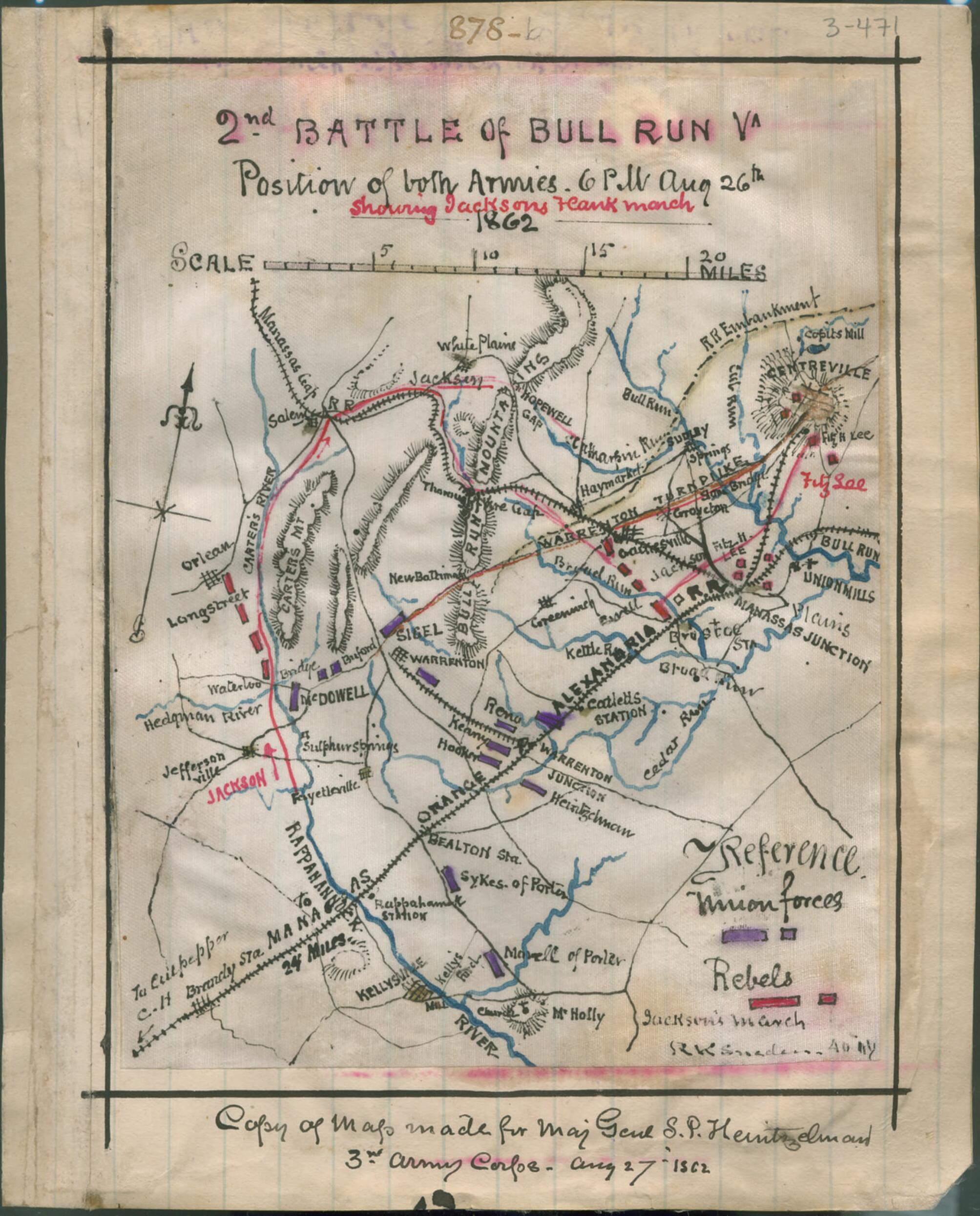
2nd Battle of Bull Run, Va. Position of Both Armies, 6 P.m. Aug. 26th 1862, Showing Jackson's Flank March 08-26
- Regular price
-
$49.95 - Regular price
-
$34.95 - Sale price
-
$49.95
Shipping calculated at checkout.
Buy one map, get any other map in our collection for 50% OFF! Add to cart to see discount.
Couldn't load pickup availability
About This Map
Old map of Manassas Region, United States, Virginia.
The map shows the area surrounding the Bull Run Mountains including Centreville and Kellysville, Va. As part of the Second Bull Run Campaign, Pope's U.S. Army of Virginia assigned to protect Washington, the Shenandoah Valley and draw Lee away from the defense of Richmond. Lee split his army, and Jackson's brilliant maneuvering thoroughly confused Pope, and allowed Longstreet to join with reinforcements. While Longstreet's failure to begin an immediate attack deprived Lee of a crushing victory, Pope still was dealt a tactical defeat and used Stone bridge to retreat over Bull Run.
Created by Robert Knox Sneden in 08-26.
- "Copy of map made for Maj Genl S.P. Heintzelman, 3rd Army Corps Aug 27th 1862" - Page caption.
- Color coding indicates the location of Union and Confederate forces.
- Relief shown by hachures.
- This item is from the collections of the Virginia Historical Society; please contact the institution for more information.
- In the Robert Knox Sneden Diary (Mss5:1 Sn237:1, v. 3, p.471 ).
- Manuscripts
Map Sizing Information
- For the best legibility, order your map in the original size or larger. Most maps have intricate detail and small text that is best appreciated when the print size hasn't been reduced.
- Sizes labeled "Fits a Standard Frame" will drop right into any frame that you purchase in that size. The sizes that we offer are commonly available online and at most retail stores.
- Our standard sizes are recommendations based on the aspect ratio of the original map, but still may require some added "white space" in one dimension to fit.
- Non-standard sizes will require custom framing, and we suggest taking your print to the frame shop of your choice after you receive it for the best results.
- Custom sizes are available, simply contact us for a quote.
Below is an approximation of the scale of a few standard sizes, and how they might appear in your space.

