
Merkatorskai︠a︡ Karta Ot 59 Do 62 Gradusov Severnoĭ Shiroty, Predstavli︠a︡i︠u︡shchai︠a︡ Dorogu Ot Goroda Okhotska Po Rekam Mai︠a︡ I I︠U︡dom. (Меркаторская карта от 59 до 62 градусов северно�...
- Regular price
-
$82.95 - Regular price
-
$77.95 - Sale price
-
$82.95
Buy one map, get any other map in our collection for 50% OFF! Add to cart to see discount.
Couldn't load pickup availability
About This Map
Discover the timeless beauty of our fine art quality printed reproduction of this antique map. Perfect for history enthusiasts, collectors, and interior decorators.
Restored with meticulous attention to detail by our team with over a decade of experience, this stunning reproduction captures the intricate artistry and historical significance of the original map.
Whether you're a collector or seeking a unique decor piece, this archival-quality map reproduction is a timeless addition to any space. Order now to bring history to life!
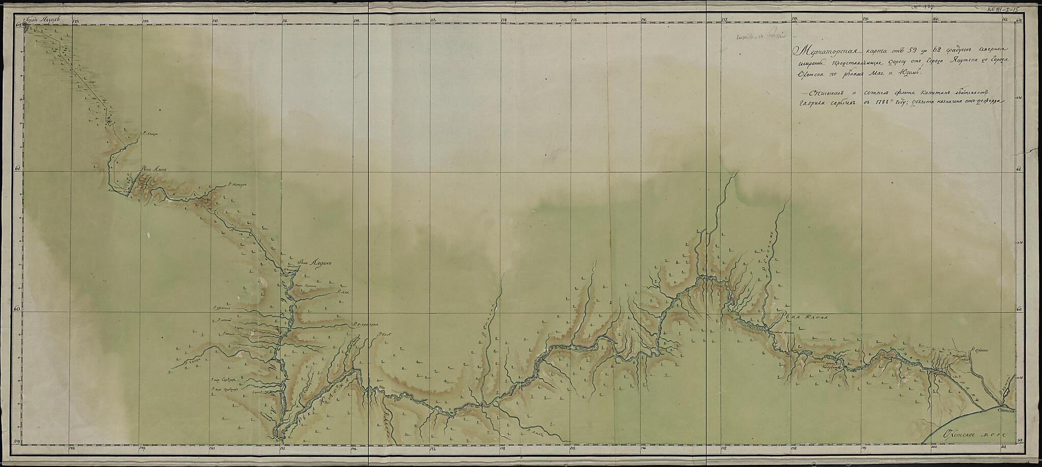
Old map of Republic, Russian Federation, Sakha, Yakutiya, Yakutsk.1831), who surveyed vast portions of the Arctic and North Pacific Oceans in the late 18th century. Sarychev's visit to the region depicted on the map took place at the time of the famous Billings-Sarychev Expedition (1785-92), in which he explored the eastern reaches of the Russian Empire in tandem with English captain Joseph Billings, who had been hired by Empress Catherine the Great for his maritime expertise. The map shows the valleys of the Maya and Yudoma Rivers in detail, including the locations of rapids and shoals as well as tributaries. Forested cliffs are indicated on the map, with representations of heavy forestation shown by tree symbols. Relief in the river valleys is indicated by brown shading. The city of Yakutsk is shown just off the upper-left-hand corner of the map, while the city of Okhotsk is indicated in the lower-right-hand corner along the Pacific coast (Sea of Okhotsk). A small black line in the upper-left-hand corner identifies the road that stretched from Yakutsk to the nearest point on the river system that led to Okhotsk. Geographic coordinates for longitude on this map are measured from Ferro (present-day Hierro), the westernmost of the Canary Islands (the western edge of the world known to the ancients), used by geographers back to the time of Ptolemy as a base point prior to the agreement in 1884 that the prime meridian would run through Greenwich, England. World Digital Library.
Created by Gavriil Andreevich Sarychev in 1788.
- Opisyval i sochini︠a︡l flota kapitan Gavriil Sarychev. T︠S︡enneĭshai︠a︡ rukopisnai︠a︡ karta, sostavlennai︠a︡ izvestnym russkim moreplavatelem G. A. Sarychevym, issledovatelem Severnogo Ledovitogo i Tikhogo okeanov, kotoryĭ proizvel gidrograficheskie raboty v raĭone Aleutskikh ostrovov. Karta byla narisovana im vo vremi︠a︡ ėkspedit︠s︡ii sovmestno s Billingsom (1785-1789). Na neĭ izobrazhen sukhoputnyĭ put' ot I︠A︡kutska do reki Mai︠a︡, a zatem po rekam Maii︠a︡ i Ĭodom. Doliny rek pokazany podrobno s ukazaniem porogov i perekatov. Lesnye sklony dolin rek izobrazheniĭ perspektivno v vide otdel'no stoi︠a︡shchikh derev'ev.
- Other form of name: Sarytschew, Gawril.
- Setka geograficheskikh koordinat ot Ferro.
- Original map at: Russian State Library
- Описывал и сочинял флота капитан Гавриил Сарычев. Ценнейшая рукописная карта, составленная известным русским мореплавателем Г. А. Сарычевым, исследователем Северного Ледовитого и Тихого океанов, который произвел гидрографические работы в районе Алеутских островов. Карта была нарисована им во время экспедиции совместно с Биллингсом (1785-1789). На ней изображен сухопутный путь от Якутска до реки Мая, а затем по рекам Маия и Йодом. Долины рек показаны подробно с указанием порогов и перекатов. Лесные склоны долин рек изображений перспективно в виде отдельно стоящих деревьев.
- Other form of name: Sarytschew, Gawril.
- Сетка географических координат от Ферро.
Map Subjects
Rivers
Russian Federation
Sakha (Yakutiya) Republic
Siberia
Yakutsk
Republic
Sakha
Yakutiya
Gavriil Andreevich Sarychev
1788
- For the best legibility, order your map in the original size or larger. Most maps have intricate detail and small text that is best appreciated when the print size hasn't been reduced.
- Sizes labeled "Fits a Standard Frame" will drop right into any frame that you purchase in that size. The sizes that we offer are commonly available online and at most retail stores.
- Our standard sizes are recommendations based on the aspect ratio of the original map, but still may require some added "white space" in one dimension to fit.
- Non-standard sizes will require custom framing, and we suggest taking your print to the frame shop of your choice after you receive it for the best results.
- Custom sizes are available, simply contact us for a quote.
Below is an approximation of the scale of a few standard sizes, and how they might appear in your space.
