
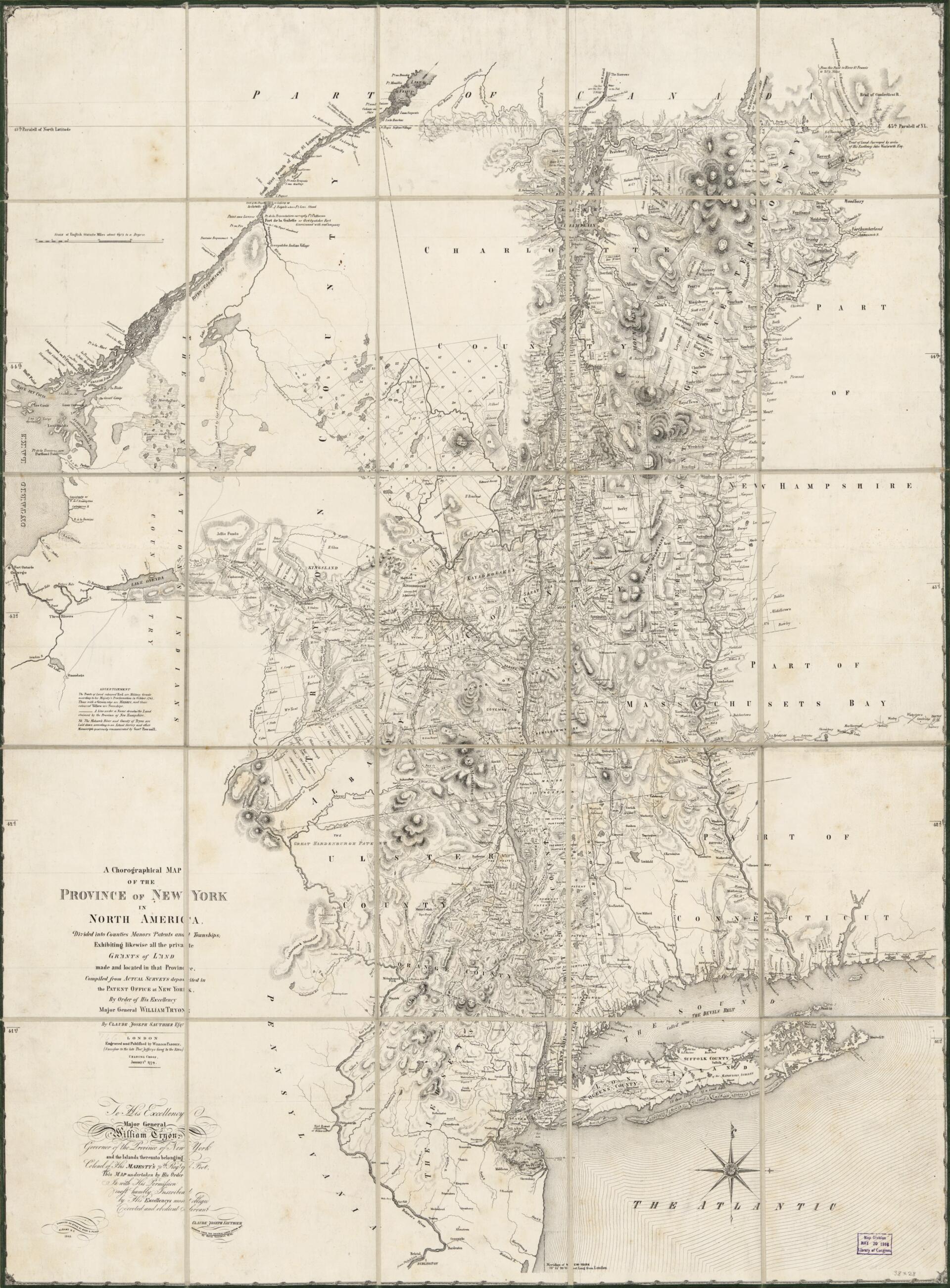
A Chorographical Map of the Province of New York In North America : Divided Into Counties, Manors, Patents, and Townships : Exhibiting Likewise All the Private Grants of Land Made and Located In That Province 1849
- Regular price
-
$111.95 - Regular price
-
$106.95 - Sale price
-
$111.95
Buy one map, get any other map in our collection for 50% OFF! Add to cart to see discount.
Couldn't load pickup availability
About This Map
Discover the timeless beauty of our fine art quality printed reproduction of this antique map. Perfect for history enthusiasts, collectors, and interior decorators.
Restored with meticulous attention to detail by our team with over a decade of experience, this stunning reproduction captures the intricate artistry and historical significance of the original map.
Whether you're a collector or seeking a unique decor piece, this archival-quality map reproduction is a timeless addition to any space. Order now to bring history to life!
Old facsimile of New York, New York (State), United States, Vermont.Created by William Faden, Millard Fillmore, Richard H. Pease, Claude Joseph Sauthier, David Vaughan in 1849.
- General-content map of eastern New York Province including Vermont and portions of adjacent provinces.
- Relief shown by hachures.
- Original title.
- Prime meridian: New York City.
- Facsimile.
- Original version: London : Engraved and published by William Fadden [thus], Charing Cross, January 4th 1779. Compiled from actual surveys deposited in the Patent Office in New York by order of His Excellency Major General William Tryon by Claude Joseph Sauthier Esqr. [Dedicated] To His Excellency Major General William Tryon, governor of the Province of New York ... Claude Joseph Sauthier.
- When affixed to the cloth backing the map sheet was sectioned to 25 panels to enable folding.
- The map cover on verso is in 2 separate panels.
- Both cover panels on the verso are signed in ink: Map of New Netherlands 1779, Millard Fillmore, July 6, 1854, no. 145.
- Includes notes and landowners' names.
- For the best legibility, order your map in the original size or larger. Most maps have intricate detail and small text that is best appreciated when the print size hasn't been reduced.
- Sizes labeled "Fits a Standard Frame" will drop right into any frame that you purchase in that size. The sizes that we offer are commonly available online and at most retail stores.
- Our standard sizes are recommendations based on the aspect ratio of the original map, but still may require some added "white space" in one dimension to fit.
- Non-standard sizes will require custom framing, and we suggest taking your print to the frame shop of your choice after you receive it for the best results.
- Custom sizes are available, simply contact us for a quote.
Below is an approximation of the scale of a few standard sizes, and how they might appear in your space.

