
A Current and Correct Depiction of Arabia Felix, Arabia Petraea, and Arabia Deserta. (Arabie Felicis, Petraeae Et Desertae Nova Et Accurata Delineatio) 1658
- Regular price
-
$97.95 - Regular price
-
$92.95 - Sale price
-
$97.95
Buy one map, get any other map in our collection for 50% OFF! Add to cart to see discount.
Couldn't load pickup availability
About This Map
Discover the timeless beauty of our fine art quality printed reproduction of this antique map. Perfect for history enthusiasts, collectors, and interior decorators.
Restored with meticulous attention to detail by our team with over a decade of experience, this stunning reproduction captures the intricate artistry and historical significance of the original map.
Whether you're a collector or seeking a unique decor piece, this archival-quality map reproduction is a timeless addition to any space. Order now to bring history to life!
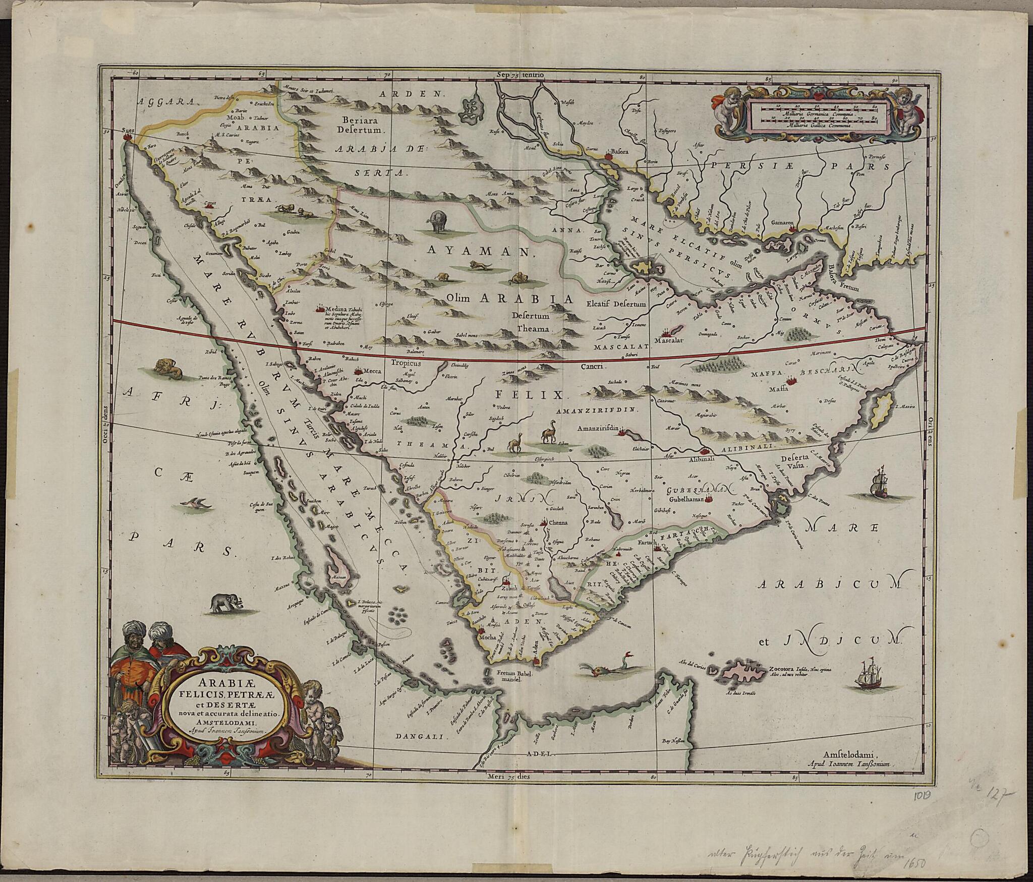
Old map of Bahrain, Iraq, Kuwait, Oman, Qatar, Saudi Arabia, United Arab Emirates, Yemen.1664), or Jan Jansson. Jansson was born in Arnhem, the son of Jan Jansson the Elder, a publisher and bookseller. Jansson's maps are similar to those of Willem Janszoon Blaeu (1571-1638), the founder of the Blaeu cartographic firm, and Jansson is sometimes accused of copying from his rival, but many of his maps predate those of Blaeu or cover different regions. This map is very similar to an earlier Blaeu map. The map shows more rivers on the Arabian Peninsula, six in total, than on many other maps. Some town names are badly copied, such as "Bocealima," which is Blaeu's "Roccalima." "Mascalat" is shown as a large and important town. There are dotted lines along the coast from "Calva" in the present-day United Arab Emirates (UAE) to beyond Bahrain Island. The Arabian Gulf is called "Mare elcatif olim Sinus Persicus" (Al Qatif Sea formerly known as the Persian Gulf) and the Strait of Hormuz called "Basora fretum" or Strait of Basra. The Red Sea is called "Mare Rubrum turcis Mare Mecca olim Sinus Arabicus" (Red Sea, named Sea of Mecca by Turks and formerly known as the Arabian Gulf).
Created by Jan Jansson in 1658.
- Title devised, in English, by Library staff.
- Original resource extent: 1 map; color; 42 x 49.50 centimeters.
- Original resource at: Qatar National Library.
- Content in Latin.
- Description based on data extracted from World Digital Library, which may be extracted from partner institutions.
Map Subjects
Arabian Peninsula
Bahrain
Iraq
Kuwait
Oman
Persian Gulf
Qatar
Saudi Arabia
United Arab Emirates
Yemen
Jan Jansson
1658
- For the best legibility, order your map in the original size or larger. Most maps have intricate detail and small text that is best appreciated when the print size hasn't been reduced.
- Sizes labeled "Fits a Standard Frame" will drop right into any frame that you purchase in that size. The sizes that we offer are commonly available online and at most retail stores.
- Our standard sizes are recommendations based on the aspect ratio of the original map, but still may require some added "white space" in one dimension to fit.
- Non-standard sizes will require custom framing, and we suggest taking your print to the frame shop of your choice after you receive it for the best results.
- Custom sizes are available, simply contact us for a quote.
Below is an approximation of the scale of a few standard sizes, and how they might appear in your space.

