
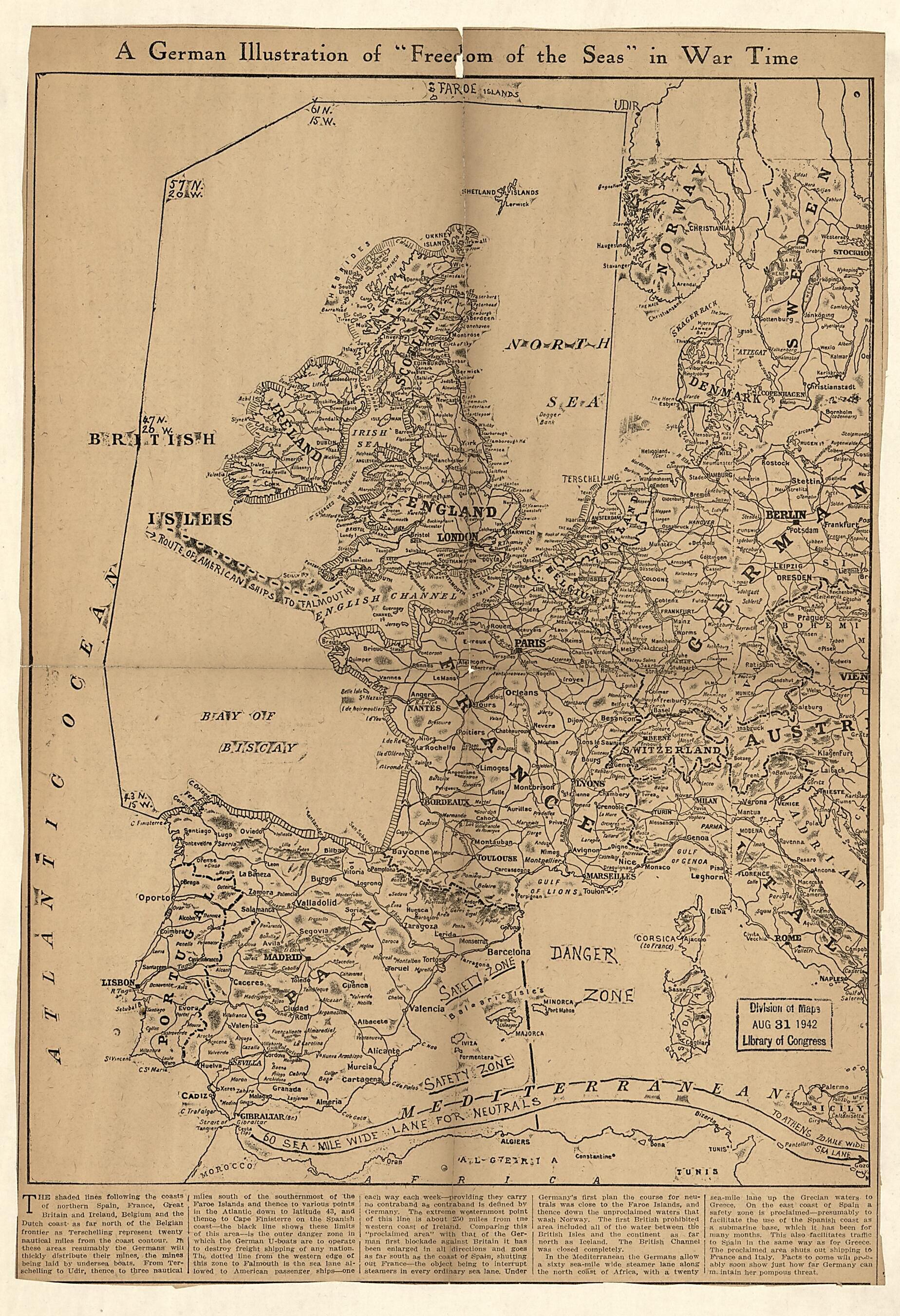
A German Illustration of freedom of the Seas In War Time : Western Europe and Western Mediterranean Sea 1915
- Regular price
-
$49.95 - Regular price
-
$34.95 - Sale price
-
$49.95
Buy one map, get any other map in our collection for 50% OFF! Add to cart to see discount.
Couldn't load pickup availability
About This Map
Discover the timeless beauty of our fine art quality printed reproduction of this antique map. Perfect for history enthusiasts, collectors, and interior decorators.
Restored with meticulous attention to detail by our team with over a decade of experience, this stunning reproduction captures the intricate artistry and historical significance of the original map.
Whether you're a collector or seeking a unique decor piece, this archival-quality map reproduction is a timeless addition to any space. Order now to bring history to life!
Old military map of Europe, Western, Mediterranean Sea, Western Europe.- Shows twenty-nautical-mile zones along Western European coastlines where German submarine mines will be distributed and an adjacent large delimited sector of the North Atlantic Ocean where Allied shipping will be prohibited; also shows a sixty-nautical-mile wide lane in the western Mediterranean Sea where neutral shipping will be allowed.
- Relief shown by hachures.
- Title from upper margin.
- Map cut from unidentified newspaper page.
- Includes text in lower margin.
- Text and illustration (both obscured) on verso.
Map Subjects
Europe Western
German
Mediterranean Sea
Military Maps
Naval Operations
Shipping
Submarine Mines
World War
Western Europe
1915
- For the best legibility, order your map in the original size or larger. Most maps have intricate detail and small text that is best appreciated when the print size hasn't been reduced.
- Sizes labeled "Fits a Standard Frame" will drop right into any frame that you purchase in that size. The sizes that we offer are commonly available online and at most retail stores.
- Our standard sizes are recommendations based on the aspect ratio of the original map, but still may require some added "white space" in one dimension to fit.
- Non-standard sizes will require custom framing, and we suggest taking your print to the frame shop of your choice after you receive it for the best results.
- Custom sizes are available, simply contact us for a quote.
Below is an approximation of the scale of a few standard sizes, and how they might appear in your space.

