
A Map of North Western Arabia and Nejd 1884
- Regular price
-
$56.95 - Regular price
-
$51.95 - Sale price
-
$56.95
Buy one map, get any other map in our collection for 50% OFF! Add to cart to see discount.
Couldn't load pickup availability
About This Map
Discover the timeless beauty of our fine art quality printed reproduction of this antique map. Perfect for history enthusiasts, collectors, and interior decorators.
Restored with meticulous attention to detail by our team with over a decade of experience, this stunning reproduction captures the intricate artistry and historical significance of the original map.
Whether you're a collector or seeking a unique decor piece, this archival-quality map reproduction is a timeless addition to any space. Order now to bring history to life!
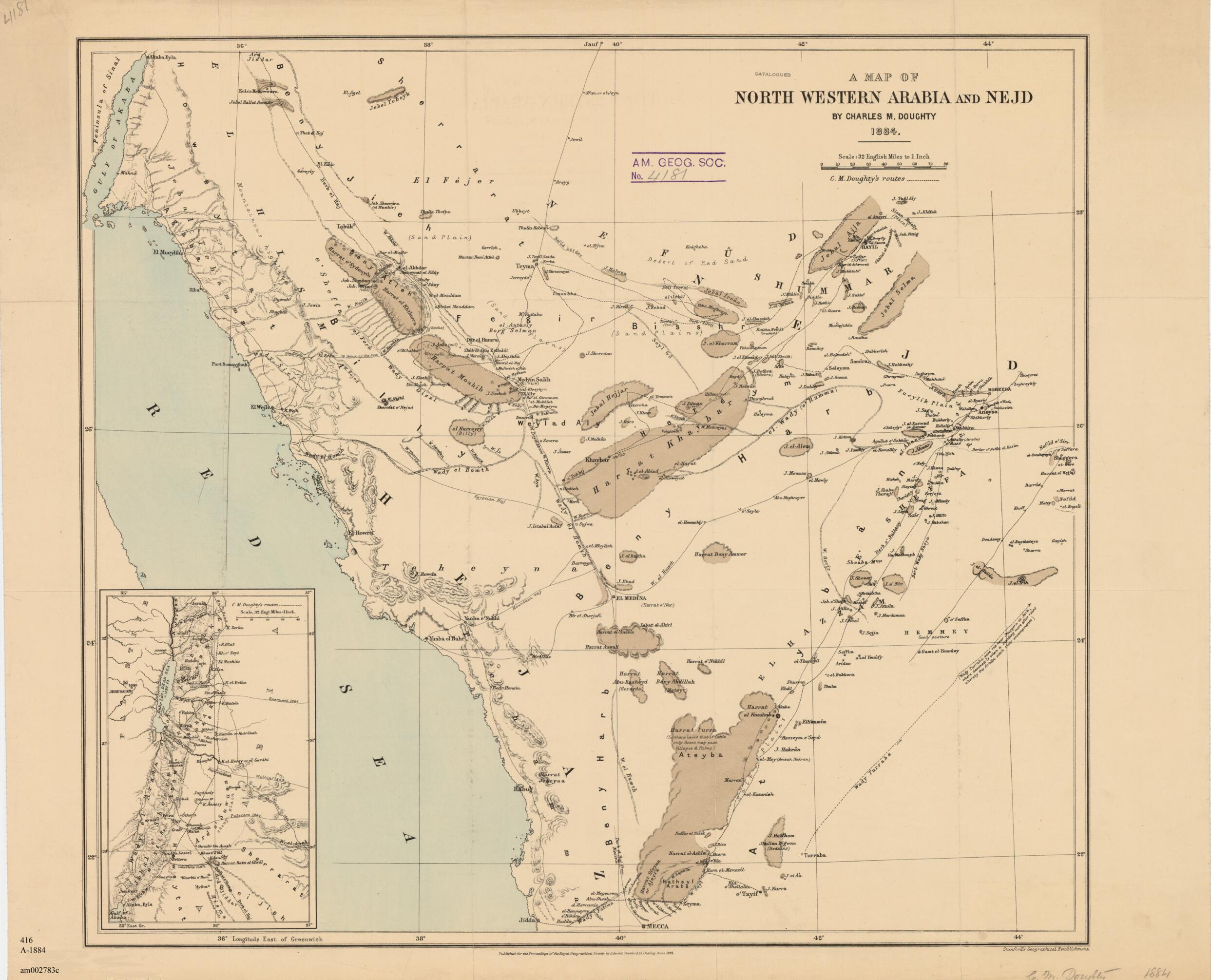
Old map of Jordan, Saudi Arabia.day Jordan and Saudi Arabia. It was drawn by British traveler Charles Montagu Doughty (1843-1926) and published in 1884. A similar map accompanied the first edition of Doughty's famous Travels in Arabia Deserta, published in 1888. The map shows northwestern Arabia and Nejd (Najd), the remote uplands of central Saudi Arabia. It shows significant topographic detail and human habitation as well as the routes Doughty took as he zigzagged with caravans and guides from Damascus to the outskirts of Mecca. The map fills a single sheet with an inset depicting the early part of Doughty's journey from Jerash, or Jarash, in the north to Aqaba in the south (both in present-day Jordan). Along with Doughty's routes, the map shows roads, settlements, caravan routes, and wadis. Relief is shown by hachures and the scale is in miles. The map was published by Edward Stanford for the Proceedings of the Royal Geographical Society. Stanford (1827--1904) was a London map seller and publisher who established his business in 1853 and who catered to explorers and political figures. Unlike many British scholar-soldier-diplomats who traveled across Arabia, Doughty was primarily a scholar. His purpose in traveling to Arabia was to shed light on one of the hinterlands of biblical history. His copies of pre-Islamic inscriptions later were published in France. His prose style was compared by some to the King James Version of the Bible, although others found fault with Doughty's combination of Victorian style and Elizabethan syntax. Doughty himself warned about Travels in Arabia Deserta, "The book is not milk for babies." After slow public recognition, the book achieved status as a classic. Doughty is also remembered for his quirky six-volume epic poem of England's mythical history, The Dawn in Britain.
Created by Charles Montagu Doughty, Royal Geographical Society (Great Britain) in 1884.
- Title devised, in English, by Library staff.
- "Scale: 1:2,027,520. 1 inch = 32 miles (2.54 centimeters = 51.49 kilometers)"--Note extracted from World Digital Library.
- Original resource extent: 1 map : color ; 45 x 51 centimeters.
- Reference extracted from World Digital Library: Doughty, Charles M. Travels in Arabia Deserta, second edition, two volumes (London: Jonathan Cape, 1921, and Boston: Warner for the Medici Society, 1921).
- Original resource at: University of Wisconsin-Milwaukee Libraries.
- Content in English.
- Description based on data extracted from World Digital Library, which may be extracted from partner institutions.
- For the best legibility, order your map in the original size or larger. Most maps have intricate detail and small text that is best appreciated when the print size hasn't been reduced.
- Sizes labeled "Fits a Standard Frame" will drop right into any frame that you purchase in that size. The sizes that we offer are commonly available online and at most retail stores.
- Our standard sizes are recommendations based on the aspect ratio of the original map, but still may require some added "white space" in one dimension to fit.
- Non-standard sizes will require custom framing, and we suggest taking your print to the frame shop of your choice after you receive it for the best results.
- Custom sizes are available, simply contact us for a quote.
Below is an approximation of the scale of a few standard sizes, and how they might appear in your space.

