
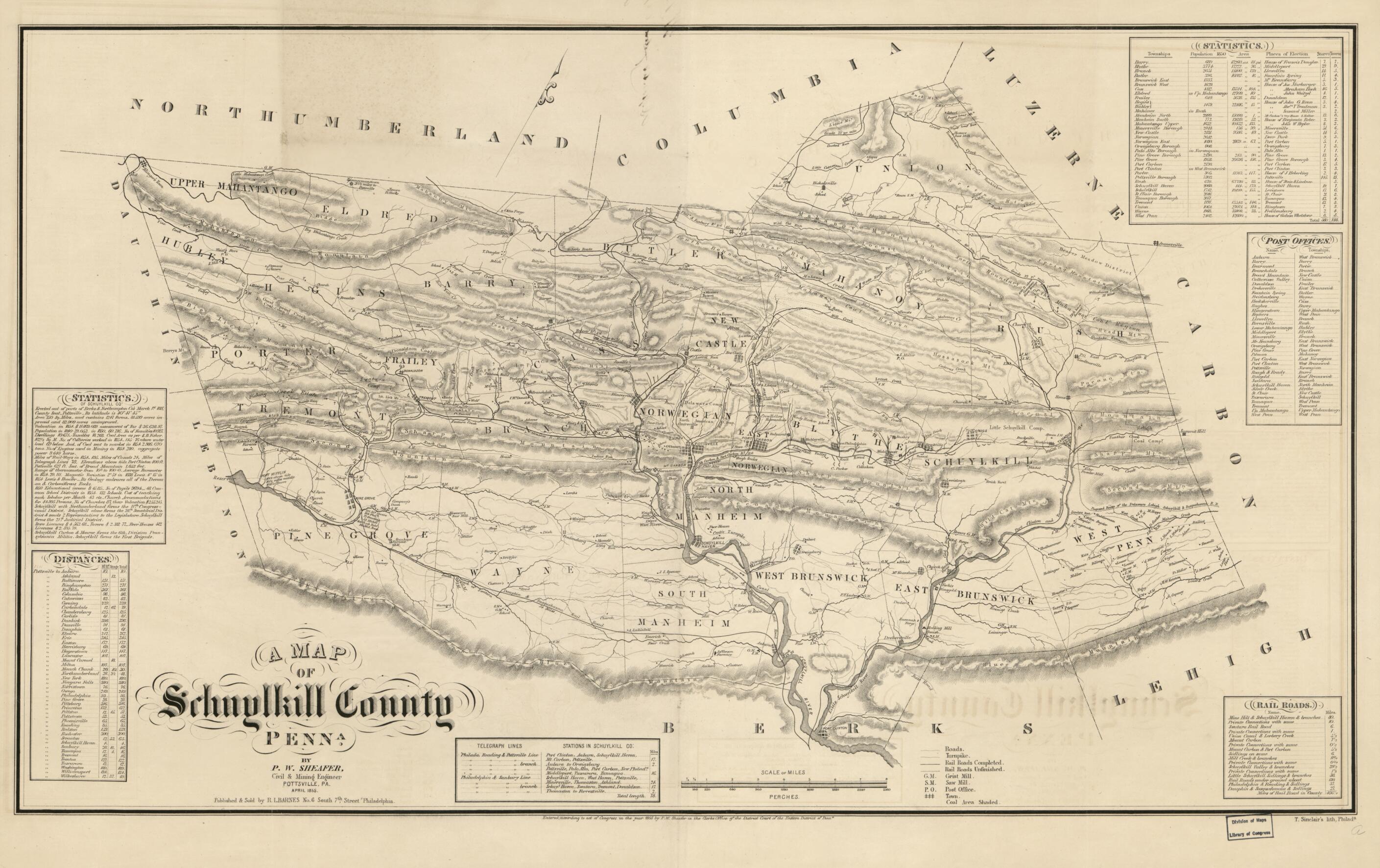
A Map of Schuylkill County, Penna 1855
- Regular price
-
$81.95 - Regular price
-
$76.95 - Sale price
-
$81.95
Buy one map, get any other map in our collection for 50% OFF! Add to cart to see discount.
Couldn't load pickup availability
About This Map
Step into history with this fine art quality printed reproduction of the Old cadastral map of Schuylkill County, Penna, originally created in 1855 by Rufus L. Barnes, P. W. (Peter Wenrick) Sheafer, with Sinclair’s Lith. This archival-quality print preserves the precise detail and charm of the 19th‑century map, offering a tactile link to a formative era of Pennsylvania’s landscape and communities.
Why this reproduction stands apart
- Faithful restoration by experts — Our team, with over a decade of experience in map restoration, recaptures the original linework, hachure relief, and careful typography to deliver a print that feels authentic to the period.
- Archival-quality presentation — Printed on durable, museum-grade stock with inks chosen for longevity, ensuring vibrant, lasting detail that resists fading over time.
- Rich historical detail — The map reveals township boundaries, railroads, rural buildings, and even householders’ names in rural areas, offering a granular glimpse into 1855 Schuylkill County life.
- Comprehensive data layers — Beyond the map itself, this reproduction includes textual elements and reference tables: land ownership text (statistics), highway distance table, statistical table, table of post-office names, table of railroad distances, and table of telegraph line data.
- Provenance and significance — Created during a pivotal era of growth and connectivity, the original map documents early infrastructure and settlement patterns that shaped modern Schuylkill County.
Ideal for whom and where it shines
- History enthusiasts and collectors who appreciate authentic 19th‑century cartography and regional studies.
- Interior decorators seeking a distinctive focal point in living rooms, studies, libraries, or offices—especially spaces with vintage, industrial, or scholarly themes.
- Educators and historical societies aiming to illustrate Pennsylvania’s development, land use, and transportation networks in a tangible format.
- Gift buyers looking for a unique, conversation‑starting keepsake that marries artistry with archival research.
What makes it practical and actionable
- Use this map as a striking framing piece to spark discussions about land ownership, early railways, and rural community life in mid‑1800s Pennsylvania.
- Pair with complementary ephemera or period prints to build a cohesive wall display that tells a story, not just a picture.
- Reference the included data tables for context on post offices, telegraph lines, and distances—useful for researchers, genealogists, and hobbyists tracing historical routes.
Quality you can trust
This reproduction is more than a decorative print—it’s a carefully curated bridge to history. The restoration honors the artistry of the original lithograph while delivering modern print clarity suitable for framing and long-term display. Whether you’re cataloging a collection or curating a space that speaks to the past, this Schuylkill County map delivers authenticity, detail, and a sense of place.
- For the best legibility, order your map in the original size or larger. Most maps have intricate detail and small text that is best appreciated when the print size hasn't been reduced.
- Sizes labeled "Fits a Standard Frame" will drop right into any frame that you purchase in that size. The sizes that we offer are commonly available online and at most retail stores.
- Our standard sizes are recommendations based on the aspect ratio of the original map, but still may require some added "white space" in one dimension to fit.
- Non-standard sizes will require custom framing, and we suggest taking your print to the frame shop of your choice after you receive it for the best results.
- Custom sizes are available, simply contact us for a quote.
Below is an approximation of the scale of a few standard sizes, and how they might appear in your space.
