
A Map of the Towns of Livingston, Germantown, and Clermont In the County of Columbia : Compiled From Actual Surveys In January in 1798
- Regular price
-
$49.95 - Regular price
-
$34.95 - Sale price
-
$49.95
Buy one map, get any other map in our collection for 50% OFF! Add to cart to see discount.
Couldn't load pickup availability
About This Map
Discover the timeless beauty of our fine art quality printed reproduction of this antique map. Perfect for history enthusiasts, collectors, and interior decorators.
Restored with meticulous attention to detail by our team with over a decade of experience, this stunning reproduction captures the intricate artistry and historical significance of the original map.
Whether you're a collector or seeking a unique decor piece, this archival-quality map reproduction is a timeless addition to any space. Order now to bring history to life!
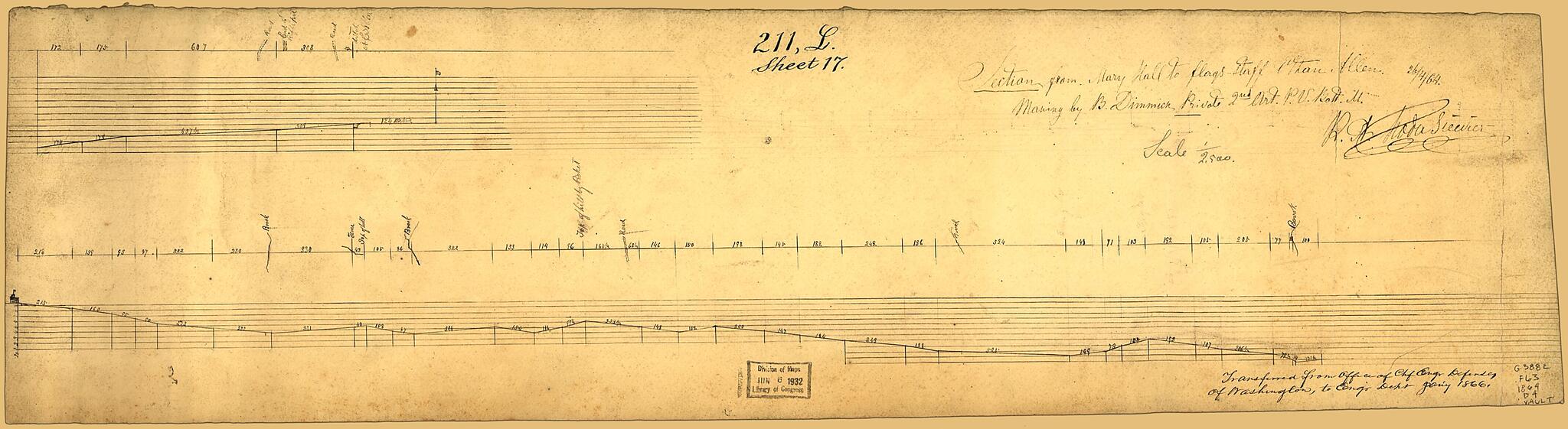
Old map of Fort Ethan Allen, United States, Virginia.Created by B. Dimmick, R. A. Hodasevich, United States. War Department. Corps of Engineers in 1864.
- Land-surface elevation profile of a line within Fort Ethan Allen, Alexandria Co. [now Arlington], Va.
- Pen-and-ink (black) and lead pencil.
- At lower right in handwriting: Transferred from Office of Chf. Engr., Defenses of Washington, to Engr. Dept. Jan'y 1866.
- This map has some imperfections: fold-lined, rubber-stamped on verso. We'll do our best to restore the image before printing.
- Drawn in 2 segments.
- Civil War Map
- Transfer; Chief Engineers Office, War Dept.
- Includes 2 strait-line diagrams of measurement points along the profile.
- At upper edge: 211, L., sheet 17.
Map Subjects
Charts Diagrams Etc
Civil War
Fort Ethan Allen
Fort Ethan Allen (Va.)
History
Maps Manuscript
United States
Virginia
B. Dimmick
R. A. Hodasevich
United States. War Department. Corps Of Engineers
1864
- For the best legibility, order your map in the original size or larger. Most maps have intricate detail and small text that is best appreciated when the print size hasn't been reduced.
- Sizes labeled "Fits a Standard Frame" will drop right into any frame that you purchase in that size. The sizes that we offer are commonly available online and at most retail stores.
- Our standard sizes are recommendations based on the aspect ratio of the original map, but still may require some added "white space" in one dimension to fit.
- Non-standard sizes will require custom framing, and we suggest taking your print to the frame shop of your choice after you receive it for the best results.
- Custom sizes are available, simply contact us for a quote.
Below is an approximation of the scale of a few standard sizes, and how they might appear in your space.
