
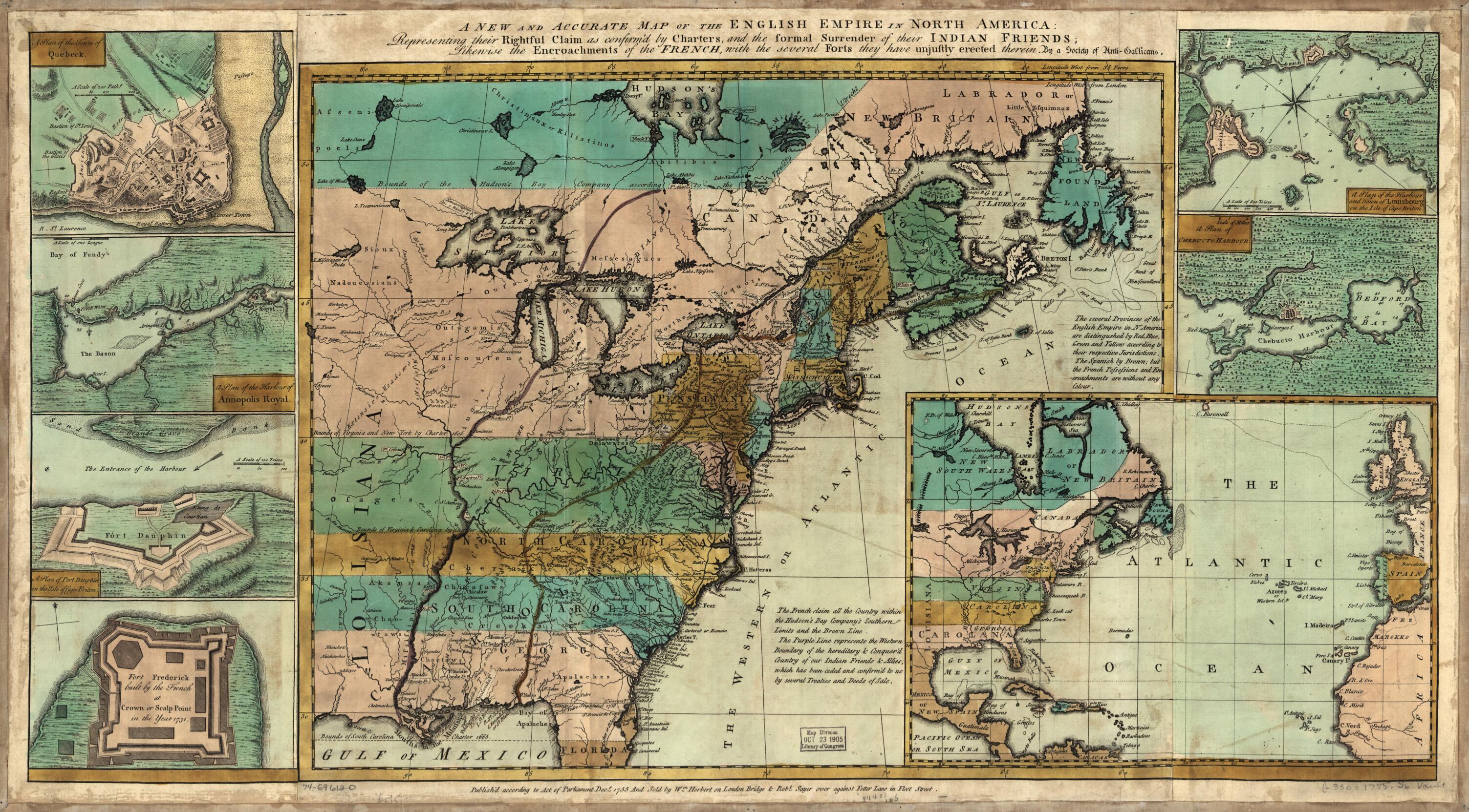
A New and Accurate Map of the English Empire In North America; Representing Their Rightful Claim As Confirmed by Charters and the Formal Surrender of Their Indian Friends; Likewise the Encroachments of the French, With the Several Forts They Have Unju...
- Regular price
-
$70.95 - Regular price
-
$65.95 - Sale price
-
$70.95
Buy one map, get any other map in our collection for 50% OFF! Add to cart to see discount.
Couldn't load pickup availability
About This Map
Discover the timeless beauty of our fine art quality printed reproduction of this antique map. Perfect for history enthusiasts, collectors, and interior decorators.
Restored with meticulous attention to detail by our team with over a decade of experience, this stunning reproduction captures the intricate artistry and historical significance of the original map.
Whether you're a collector or seeking a unique decor piece, this archival-quality map reproduction is a timeless addition to any space. Order now to bring history to life!
Old map of Annapolis Royal, Canada, North America, Nova Scotia, Québec.Created by William Herbert, Robert Sayer, Gallicans in 1755.
- Scale ca. 1:7,200,000.
- Hand colored.
- Relief shown pictorially.
- "Longitude west from Ferro."
- "Sold by Wm. Herbert ... & Robt. Sayer ... "
- Includes notes.
- Maps in margin: A plan of the harbor and town of Louisbourg on the isle of Cape Briton.--A plan of Chebucto Harbor.--The Atlantic Ocean.--Fort Frederick built by the French at Crown or Scalp Point in the year 1731.--A plan of Port Dauphin on the isle of Cape Briton.--A plan of the harbour of Annopolis Royal.--A plan of the town of Quebeck.
- For the best legibility, order your map in the original size or larger. Most maps have intricate detail and small text that is best appreciated when the print size hasn't been reduced.
- Sizes labeled "Fits a Standard Frame" will drop right into any frame that you purchase in that size. The sizes that we offer are commonly available online and at most retail stores.
- Our standard sizes are recommendations based on the aspect ratio of the original map, but still may require some added "white space" in one dimension to fit.
- Non-standard sizes will require custom framing, and we suggest taking your print to the frame shop of your choice after you receive it for the best results.
- Custom sizes are available, simply contact us for a quote.
Below is an approximation of the scale of a few standard sizes, and how they might appear in your space.
