
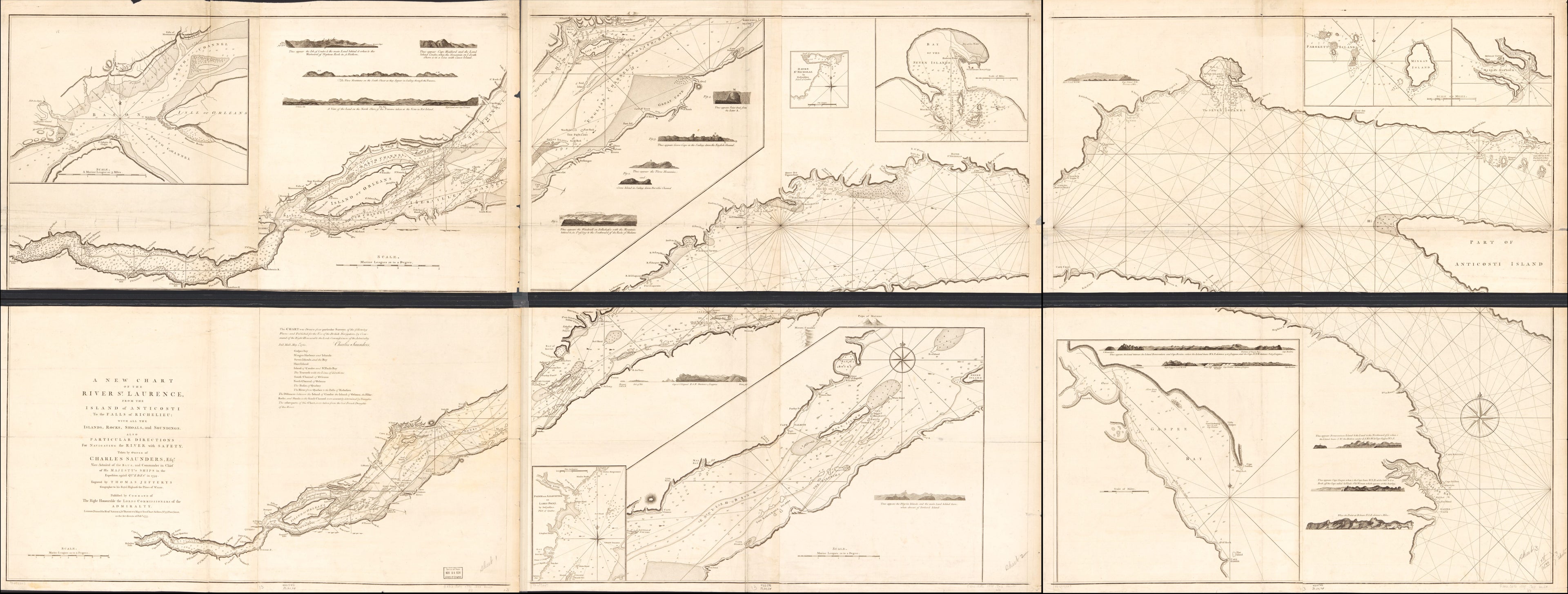
A New Chart of the River St. Laurence, From the Island of Anticosti to the Falls of Richelieu: With All the Islands, Rocks, Shoals, and Soundings, Also Particular Directions for Navigating the River With Safety. Taken by the Order of Charles Saunders,...
- Regular price
-
$286.95 - Regular price
-
$281.95 - Sale price
-
$286.95
Buy one map, get any other map in our collection for 50% OFF! Add to cart to see discount.
Couldn't load pickup availability
About This Map
Discover the timeless beauty of our fine art quality printed reproduction of this antique map. Perfect for history enthusiasts, collectors, and interior decorators.
Restored with meticulous attention to detail by our team with over a decade of experience, this stunning reproduction captures the intricate artistry and historical significance of the original map.
Whether you're a collector or seeking a unique decor piece, this archival-quality map reproduction is a timeless addition to any space. Order now to bring history to life!
Old map of North America, Saint Lawrence River.Created by Thomas Jefferys, Robert Sayer and John Bennett (Firm) in 1775.
- Scale ca. 1:150,000.
- Relief shown pictorially and by hachures. Depths shown in fathoms.
- Each sheet composed of 4 sections glued together.
- "This chart was drawn from particular surveys of the following places; and published for the use of British navigators, by command of the Right Honourable the Lords Commissioners of the Admiralty, Charles Saunder, Pall Mall, May 1st., 1760."
- Shows settlements, ship channels, and anchorages.
- Appears in the author's The North American Pilot for Newfoundland, Labradore, the gulf and river St. Laurence. 1777.
- Pl. no.: XXII, XXI, XX.
- Includes text, 17 coastal views, and 9 insets.
- For the best legibility, order your map in the original size or larger. Most maps have intricate detail and small text that is best appreciated when the print size hasn't been reduced.
- Sizes labeled "Fits a Standard Frame" will drop right into any frame that you purchase in that size. The sizes that we offer are commonly available online and at most retail stores.
- Our standard sizes are recommendations based on the aspect ratio of the original map, but still may require some added "white space" in one dimension to fit.
- Non-standard sizes will require custom framing, and we suggest taking your print to the frame shop of your choice after you receive it for the best results.
- Custom sizes are available, simply contact us for a quote.
Below is an approximation of the scale of a few standard sizes, and how they might appear in your space.
