
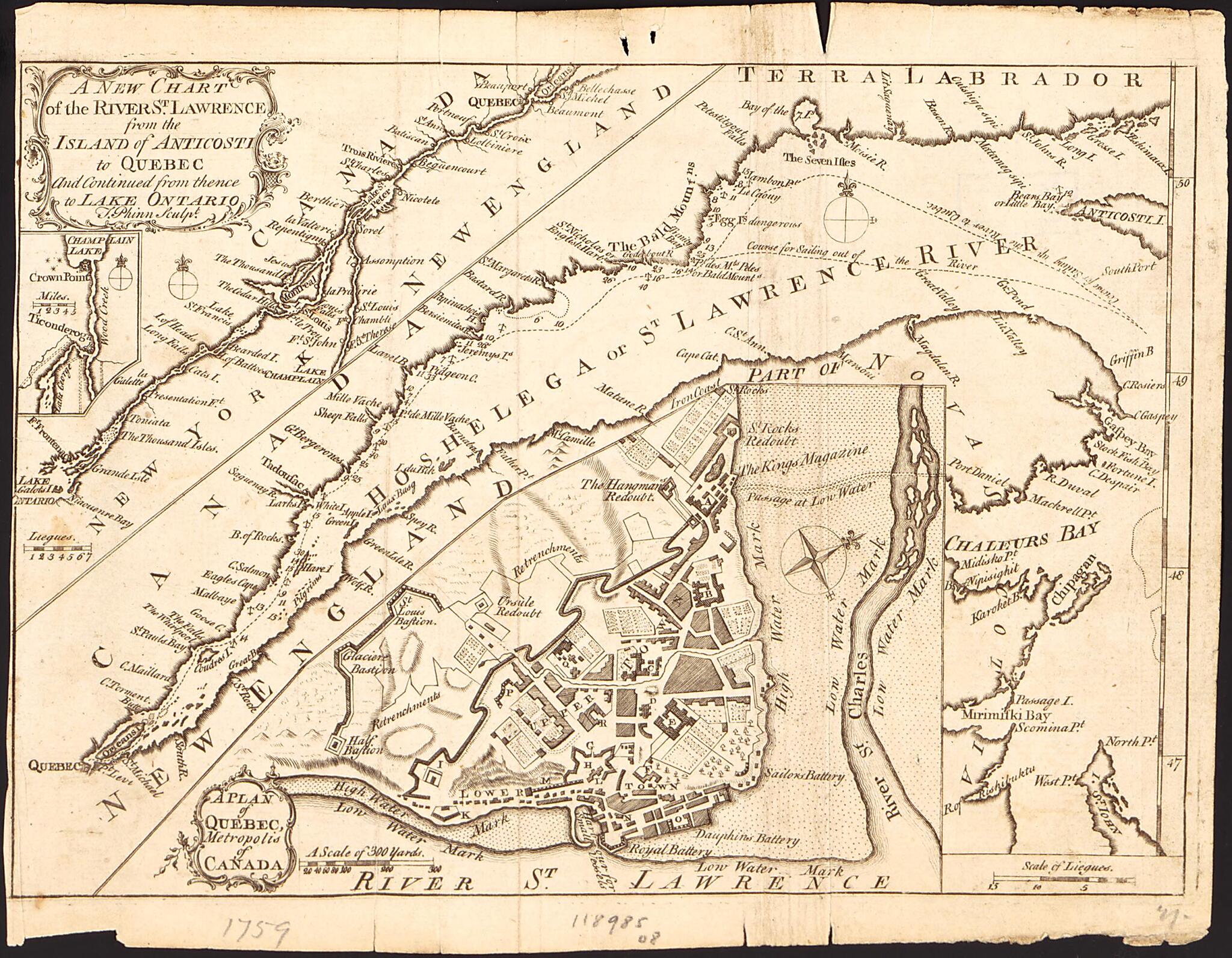
A New Chart of the River St. Lawrence from the Island of Anticosti to Quebec and Continued from Thence to Lake Ontario 1759
- Regular price
-
$49.95 - Regular price
-
$34.95 - Sale price
-
$49.95
Buy one map, get any other map in our collection for 50% OFF! Add to cart to see discount.
Couldn't load pickup availability
About This Map
Discover the timeless beauty of our fine art quality printed reproduction of this antique map. Perfect for history enthusiasts, collectors, and interior decorators.
Restored with meticulous attention to detail by our team with over a decade of experience, this stunning reproduction captures the intricate artistry and historical significance of the original map.
Whether you're a collector or seeking a unique decor piece, this archival-quality map reproduction is a timeless addition to any space. Order now to bring history to life!
Old nautical chart / early map of Canada, Lake, New York, New York (State), Ontario, Ontario, Lake, Saint Lawrence River, United States.Created by Thomas Phin, Limited Scots Magazine in 1759.
- Shows routes of navigation, anchorages, rocks and islands in the river, shoals, bays and inlets, some soundings, place-names, and relief.
- Relief shown by hachures and spot heights. Depths shown by soundings.
- From the Scots Magazine (September, 1759), volume 20.
- Includes insets: A plan of Quebec, Metropolis of Canada (scale approximately 1:10,000) and [Lake Champlain to Lake George] (scale approximately 1:10,000).
- Copy This map has some imperfections: discoloration and trimmed. We'll do our best to restore the image before printing.
Map Subjects
Canada
Early Maps
Early Works To 1800
Nautical Charts
New York (State)
Ontario
Ontario Lake
Ontario Lake (N.Y. And Ont.)
Saint Lawrence River
United States
Lake
New York
Nautical Charts
Early Maps
Thomas Phin
Limited Scots Magazine
1759
- For the best legibility, order your map in the original size or larger. Most maps have intricate detail and small text that is best appreciated when the print size hasn't been reduced.
- Sizes labeled "Fits a Standard Frame" will drop right into any frame that you purchase in that size. The sizes that we offer are commonly available online and at most retail stores.
- Our standard sizes are recommendations based on the aspect ratio of the original map, but still may require some added "white space" in one dimension to fit.
- Non-standard sizes will require custom framing, and we suggest taking your print to the frame shop of your choice after you receive it for the best results.
- Custom sizes are available, simply contact us for a quote.
Below is an approximation of the scale of a few standard sizes, and how they might appear in your space.

