
A New Map of Arabia: Divided Into Its Several Regions and Districts. (A New Map of Arabia: Divided Into Its Several Regions and Districts) 1794
- Regular price
-
$103.95 - Regular price
-
$98.95 - Sale price
-
$103.95
Buy one map, get any other map in our collection for 50% OFF! Add to cart to see discount.
Couldn't load pickup availability
About This Map
Discover the timeless beauty of our fine art quality printed reproduction of this antique map. Perfect for history enthusiasts, collectors, and interior decorators.
Restored with meticulous attention to detail by our team with over a decade of experience, this stunning reproduction captures the intricate artistry and historical significance of the original map.
Whether you're a collector or seeking a unique decor piece, this archival-quality map reproduction is a timeless addition to any space. Order now to bring history to life!
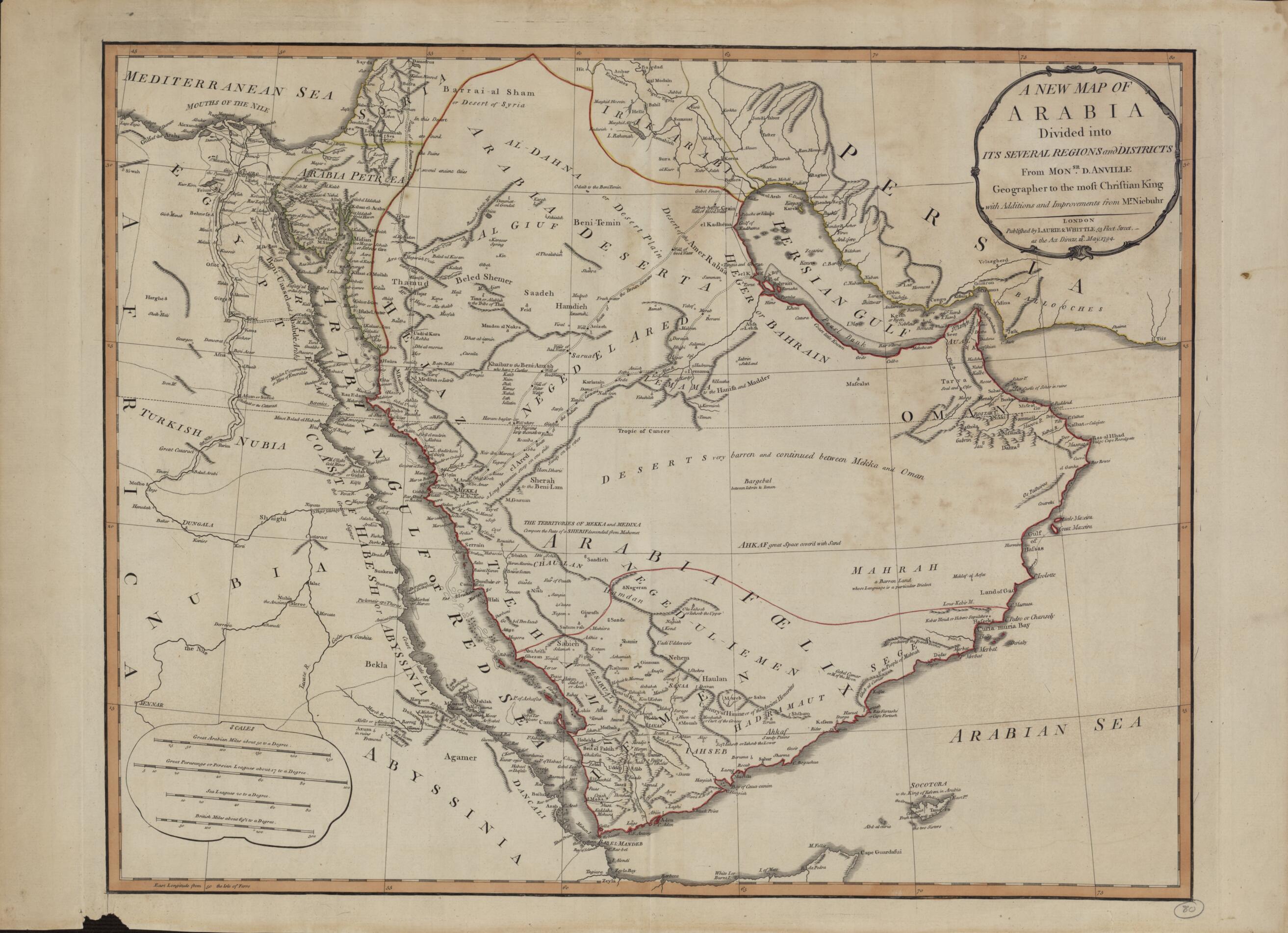
Old map of Bahrain, Djibouti, Egypt, Eritrea, Ethiopia, Iran, Islamic Republic of, Iraq, Israel, Jordan, Kuwait, Oman, Qatar, Saudi Arabia, Sudan, United Arab Emirates, Yemen.Baptiste Bourguignon d'Anville (1697-1782). Appointed the first geographer to the king of France in 1773, d'Anville was one of the most important mapmakers of the 18th century, known for the accuracy and scientific quality of his maps. The work presented here is said to contain "Additions and Improvements from Mr. Niebuhr," a reference to Carsten Niebuhr (1733--1815), a German-born Danish explorer and civil engineer who journeyed through Arabia and Yemen in 1762--67 and whose Travels through Arabia and Other Countries in the East (an abridged translation from the original German) was published in Edinburgh in 1792. The map includes cities and towns, coastlines, caravan routes to Mecca, wells, mines, and other geographic features, and brief notations on some of the peoples and kingdoms of the Arabian Peninsula. Qatar is shown as "Catura," with the notation "Coast little Known" just south of its location. Four distance scales are given: great Arabian miles, great parasangs or Persian leagues, sea leagues, and British miles. The map was published by the London firm of Laurie & Whittle, a partnership of the engraver Robert Laurie (circa 1755-1836) and print seller James Whittle (1757-1818) that was known for its accurate maps and nautical charts.
Created by Baptiste Bourguignon D, Carsten Niebuhr in 1794.
- Title devised, in English, by Library staff.
- Original resource extent: 1 map ; 46.5 x 59 centimeters.
- Original resource at: Qatar National Library.
- Content in English.
- Description based on data extracted from World Digital Library, which may be extracted from partner institutions.
- For the best legibility, order your map in the original size or larger. Most maps have intricate detail and small text that is best appreciated when the print size hasn't been reduced.
- Sizes labeled "Fits a Standard Frame" will drop right into any frame that you purchase in that size. The sizes that we offer are commonly available online and at most retail stores.
- Our standard sizes are recommendations based on the aspect ratio of the original map, but still may require some added "white space" in one dimension to fit.
- Non-standard sizes will require custom framing, and we suggest taking your print to the frame shop of your choice after you receive it for the best results.
- Custom sizes are available, simply contact us for a quote.
Below is an approximation of the scale of a few standard sizes, and how they might appear in your space.

