
A New Map of Arabia, Including Egypt, Abyssinia, the Red Sea, from the Latest Authorities. (A New Map of Arabia, Including Egypt, Abyssinia, the Red Sea &c., &c., from the Latest Authorities) 1804
- Regular price
-
$88.95 - Regular price
-
$83.95 - Sale price
-
$88.95
Buy one map, get any other map in our collection for 50% OFF! Add to cart to see discount.
Couldn't load pickup availability
About This Map
Discover the timeless beauty of our fine art quality printed reproduction of this antique map. Perfect for history enthusiasts, collectors, and interior decorators.
Restored with meticulous attention to detail by our team with over a decade of experience, this stunning reproduction captures the intricate artistry and historical significance of the original map.
Whether you're a collector or seeking a unique decor piece, this archival-quality map reproduction is a timeless addition to any space. Order now to bring history to life!
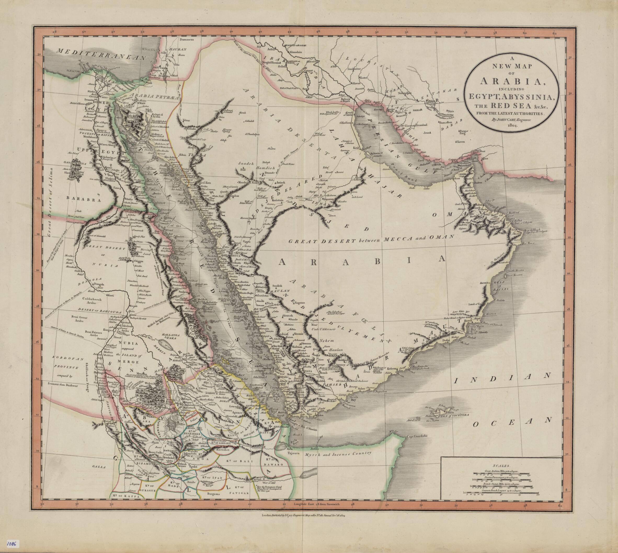
Old map of Bahrain, Djibouti, Egypt, Eritrea, Iraq, Israel, Jordan, Kuwait, Oman, Qatar, Saudi Arabia, Somalia, Sudan, Syrian Arab Republic, United Arab Emirates, Yemen.1835) was a leading London engraver, map-, chart- and print-seller, and globe maker, active between 1787 and 1834. This map of 1804 shows the Arabian Peninsula and neighboring parts of Africa and the Middle East. Important caravan routes are marked, including the "route of the grand caravan of Sudan from the Niger to Cairo," "route of the caravan from Batsora [Basra] to Aleppo," "caravan of Darfowar [Darfur] to Mecca by Dongola," "caravan of Sudan directly to Mecca by Suakem," and several other caravan routes to Mecca. Many African kingdoms are shown, their borders marked with colored lines, as is a speculative source of the Nile. The northern coast of Somalia is called "Myrrh and Incense Country." The zigzag line in the Red Sea indicates the course of La Venus, a French frigate that sailed on a voyage of discovery in the Red Sea, Persian Gulf, and Indian Ocean in 1785-88. The map includes many other notes that reflect the state of European geographic understanding of this region at the beginning of the 19th century. Four distance scales are given: great Arabian miles, Persian parasangs, British statute miles, and common French leagues.
Created by John Cary in 1804.
- Title devised, in English, by Library staff.
- "Scale approximately 1:6,500,000"--Note extracted from World Digital Library.
- Original resource extent: 1 map : hand colored ; 44 x 50 centimeters.
- Reference extracted from World Digital Library: Sir Herbert George Fordham, John Cary, Engraver & Map-Seller (fl. 1769-1836): A Paper Read at a Meeting of the Cambridge Antiquarian Society, December 6th, 1909 (Cambridge: J. Webb, 1910).
- Original resource at: Qatar National Library.
- Content in English.
- Description based on data extracted from World Digital Library, which may be extracted from partner institutions.
- For the best legibility, order your map in the original size or larger. Most maps have intricate detail and small text that is best appreciated when the print size hasn't been reduced.
- Sizes labeled "Fits a Standard Frame" will drop right into any frame that you purchase in that size. The sizes that we offer are commonly available online and at most retail stores.
- Our standard sizes are recommendations based on the aspect ratio of the original map, but still may require some added "white space" in one dimension to fit.
- Non-standard sizes will require custom framing, and we suggest taking your print to the frame shop of your choice after you receive it for the best results.
- Custom sizes are available, simply contact us for a quote.
Below is an approximation of the scale of a few standard sizes, and how they might appear in your space.

