
1
/
of
1
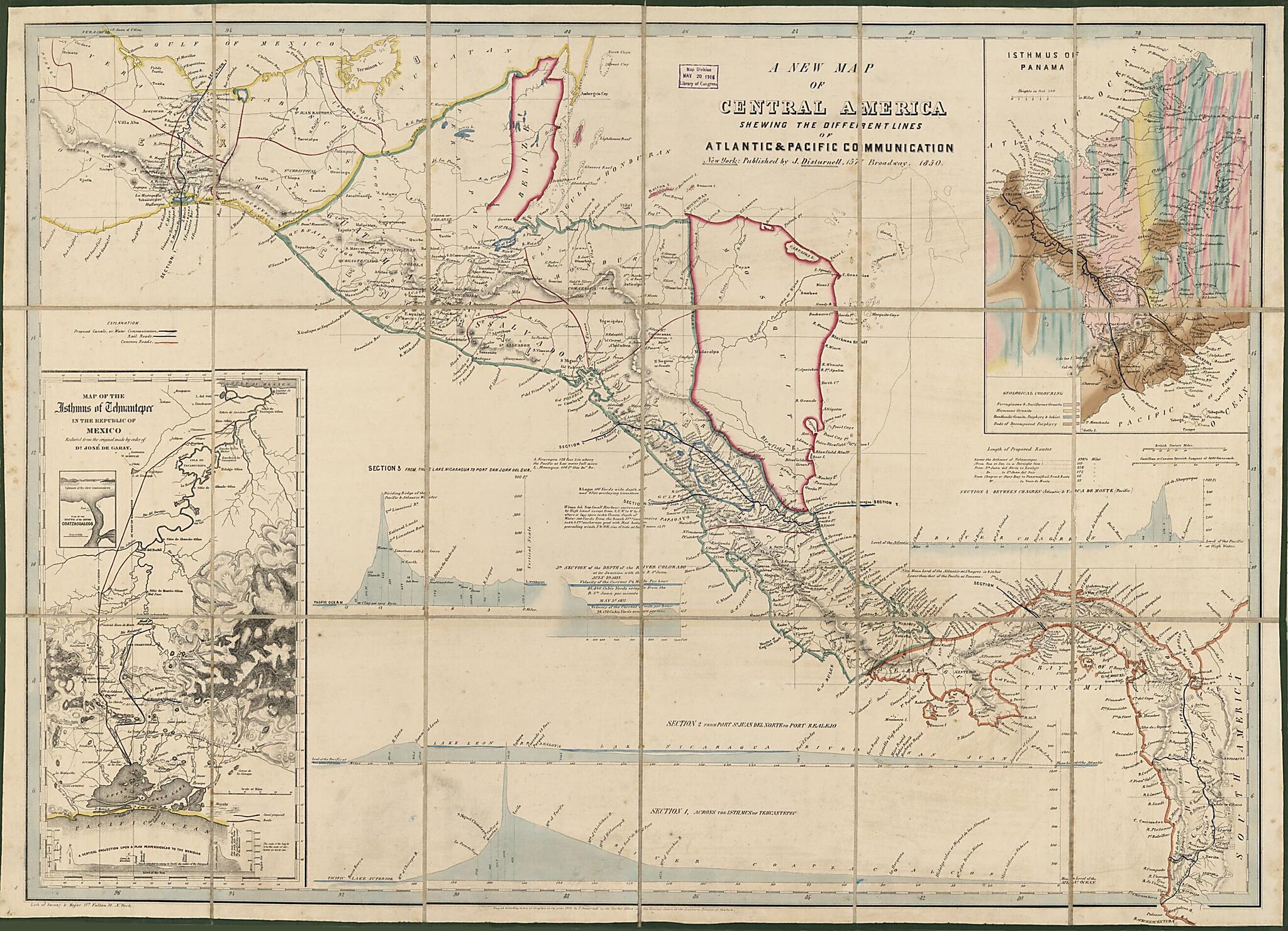
A New Map of Central America : Shewing the Different Lines of Atlantic & Pacific Communication (Central America) 1850
- Regular price
-
$83.95 - Regular price
-
$133.99 - Sale price
-
$83.95
Map Description
Old map of Central America, Coatzacoalcos River, Isthmus of, Mexico, Panama, Panama, Isthmus Of., Tehuantepec, Tehuantepec, Isthmus Of..
Created by John Disturnell, José De Garay, Sarony & Major in 1850.
Created by John Disturnell, José De Garay, Sarony & Major in 1850.
- Shows railroads, proposed canals or water communications, common roads, gold and silver mines, major cities and towns.
- Relief shown by hachures and spot heights.
- "Entered according to Act of Congress in the year 1850 by J. Disturnell in the Clerks Office of the District Court of the Southern District of New York."
- In lower left margin: Lith. of Sarony and Major, 117 Fulton St., N. York.
- For 1851 edition, see Fillmore map collection, no. 210.
- Includes text, notes, 2 insets: Map of the Isthmus of Tehuantepec in the Republic of Mexico reduced from the original by order of Dn. José de Garay -- Isthmus of Panama, and 5 geologic cross sections.
Map Subjects
Canals
Central America
Charts Diagrams Etc
Coatzacoalcos River
Coatzacoalcos River (Mexico)
Gold Mines And Mining
Mexico
Panama
Panama Isthmus Of
Panama Isthmus Of (Panama)
Railroads
Silver Mines And Mining
Tehuantepec Isthmus Of
Tehuantepec Isthmus Of (Mexico)
Isthmus Of
Panama Isthmus Of.
Tehuantepec
Tehuantepec Isthmus Of.
John Disturnell
José De Garay
Sarony & Major
1850
Map Tags
1850
Canals
Central America
Charts Diagrams Etc
Coatzacoalcos River
Coatzacoalcos River (Mexico)
Gold Mines And Mining
Isthmus Of
John Disturnell
José De Garay
Map
Maps
Mexico
Panama
Panama Isthmus Of
Panama Isthmus Of (Panama)
Railroads
Sarony & Major
Silver Mines And Mining
Tehuantepec
Tehuantepec Isthmus Of
Tehuantepec Isthmus Of (Mexico)
Fine Art Quality
Printed on heavyweight (230 gsm) archival paper with a classic matte finish
Professionally Restored
For the best presentation, your map will be carefully retouched by our experienced team
Free Shipping
Orders of $75 or more ship for free and arrive in 3-5 business days
Proudly Made in the USA
All of our maps are custom printed to order in Portland, Maine
Couldn't load pickup availability
Secure Checkout
Lifetime Warranty
Money-Back Guarantee
Map Sizing Information
- For the best legibility, order your map in the original size or larger. Most maps have intricate detail and small text that is best appreciated when the print size hasn't been reduced.
- Sizes labeled "Fits a Standard Frame" will drop right into any frame that you purchase in that size. The sizes that we offer are commonly available online and at most retail stores.
- Our standard sizes are recommendations based on the aspect ratio of the original map, but still may require some added "white space" in one dimension to fit.
- Non-standard sizes will require custom framing, and we suggest taking your print to the frame shop of your choice after you receive it for the best results.
- Custom sizes are available, simply contact us for a quote.
Below is an approximation of the scale of a few standard sizes, and how they might appear in your space.
