
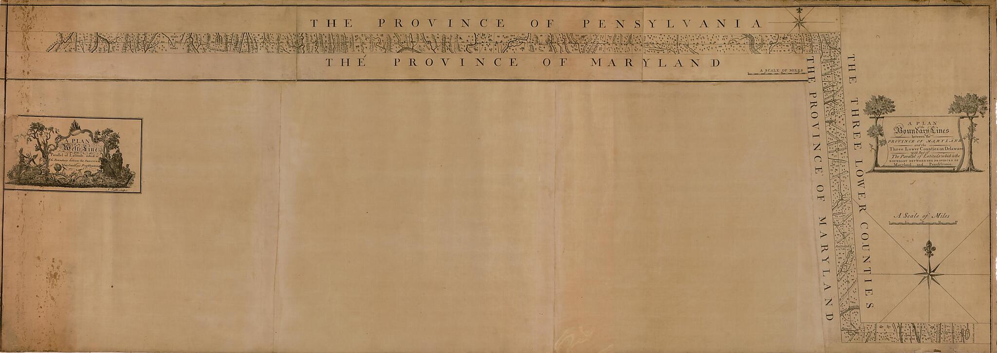
A Plan of the West Line Or Parallel of Latitude, Which Is the Boundary Between the Provinces of Maryland and Pensylvania : a Plan of the Boundary Lines Between the Province of Maryland and the Three Lower Counties On Delaware With Part of the Parallel...
- Regular price
-
$200.95 - Regular price
-
$195.95 - Sale price
-
$200.95
Buy one map, get any other map in our collection for 50% OFF! Add to cart to see discount.
Couldn't load pickup availability
About This Map
Discover the timeless beauty of our fine art quality printed reproduction of this antique map. Perfect for history enthusiasts, collectors, and interior decorators.
Restored with meticulous attention to detail by our team with over a decade of experience, this stunning reproduction captures the intricate artistry and historical significance of the original map.
Whether you're a collector or seeking a unique decor piece, this archival-quality map reproduction is a timeless addition to any space. Order now to bring history to life!
Old map of Delaware, Maryland, Pennsylvania, United States.Dixon Line, traditionally thought of as the divide between North and South in the United States and, before the Civil War, between the slaveholding and non-slaveholding states. In the 1700s, a boundary dispute arose between the British colonies of Maryland and Pennsylvania. They agreed to resolve the dispute by having two English astronomers, Charles Mason (1728-86) and Jeremiah Dixon (1733-79), survey the border. Mason and Dixon completed their survey in 1767 and set up milestones to mark the line. This map was made by Mason and published in Philadelphia in 1768. The Mason-Dixon Line was resurveyed in 1849, 1900, and, most recently, the 1960s and has proven to be highly accurate. Today, the line is set at 39°43'19.521" north latitude. It forms the boundary between Pennsylvania and Maryland, between Pennsylvania and part of West Virginia, and the north-south boundary between Maryland and Delaware. The origin of "Dixie," the traditional nickname for the American South and the unofficial national anthem of the Confederacy during the Civil War, is obscure, but one theory holds that the name derives from Jeremiah Dixon." World Digital Library.
Created by Jeremiah Dixon, Robert Kennedy, Charles Mason, James Smither in 1768.
- First part of title appears at left margin, second part at right margin.
- Includes ill. in cartouches.
- Originally issued on 2 sheets.
- Relief shown pictorially.
- Shows the Mason and Dixon line.
- LAC ddw 2023-06-13 update (1 card)
Map Subjects
Boundaries
Delaware
Early Works To 1800
Maryland
Dixon Line
Pennsylvania
United States
Jeremiah Dixon
Robert Kennedy
Charles Mason
James Smither
1768
- For the best legibility, order your map in the original size or larger. Most maps have intricate detail and small text that is best appreciated when the print size hasn't been reduced.
- Sizes labeled "Fits a Standard Frame" will drop right into any frame that you purchase in that size. The sizes that we offer are commonly available online and at most retail stores.
- Our standard sizes are recommendations based on the aspect ratio of the original map, but still may require some added "white space" in one dimension to fit.
- Non-standard sizes will require custom framing, and we suggest taking your print to the frame shop of your choice after you receive it for the best results.
- Custom sizes are available, simply contact us for a quote.
Below is an approximation of the scale of a few standard sizes, and how they might appear in your space.
