
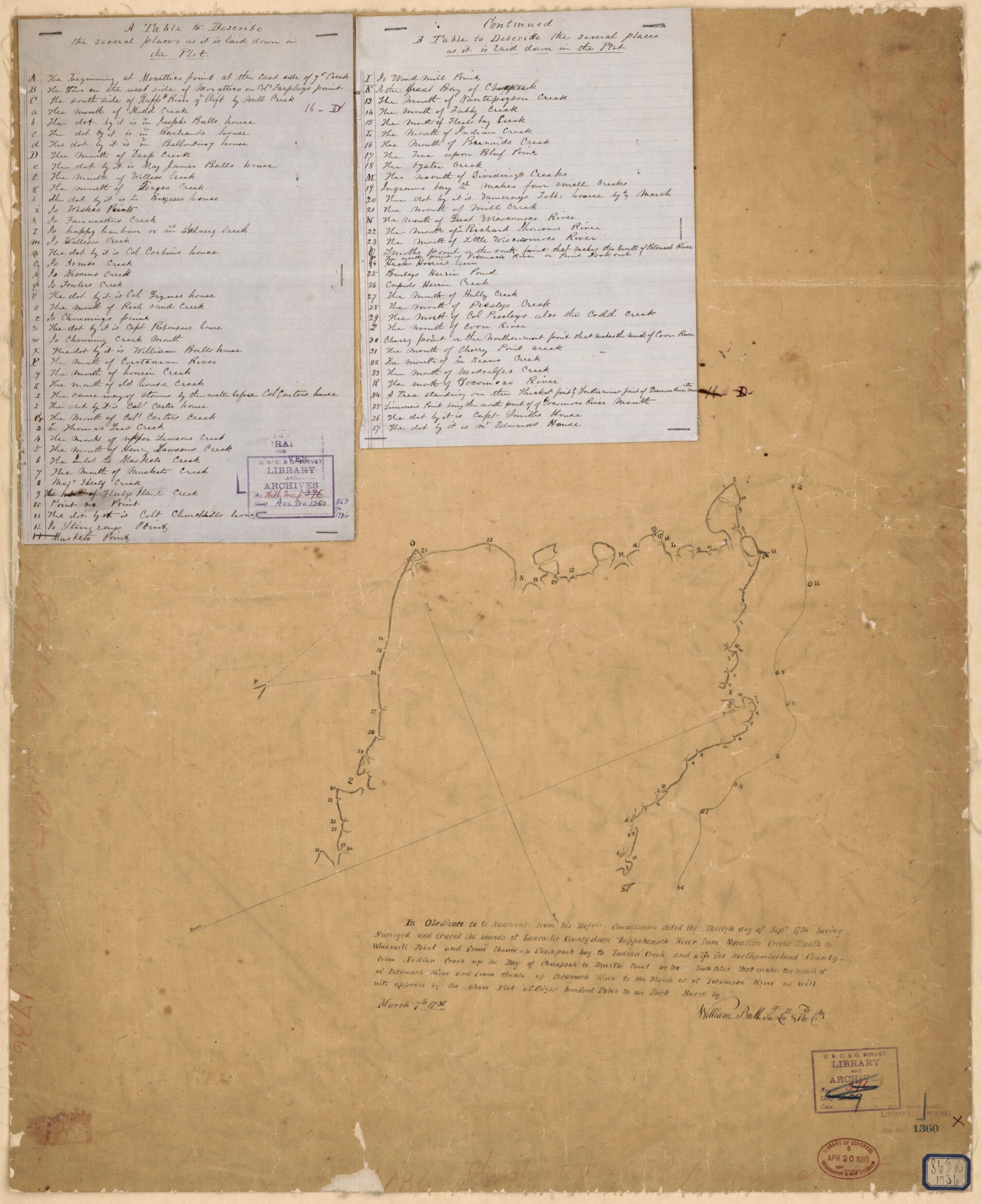
A Survey of a Plot In Lancaster and Northumberland Counties Bounded by the Chesapeake Bay, Rappahnnock River, and the Potomac River in 1736
- Regular price
-
$72.95 - Regular price
-
$67.95 - Sale price
-
$72.95
Buy one map, get any other map in our collection for 50% OFF! Add to cart to see discount.
Couldn't load pickup availability
About This Map
Discover the timeless beauty of our fine art quality printed reproduction of this antique map. Perfect for history enthusiasts, collectors, and interior decorators.
Restored with meticulous attention to detail by our team with over a decade of experience, this stunning reproduction captures the intricate artistry and historical significance of the original map.
Whether you're a collector or seeking a unique decor piece, this archival-quality map reproduction is a timeless addition to any space. Order now to bring history to life!
Old map of Lancaster County, Northumberland County, United States, Virginia.Created by William Ball in 1736.
- Relief shown by hachures.
- Cadastral survey map.
- Title devised by cataloger.
- Pen-and-ink on tracing paper, mounted on cloth with an index of place names and resident houses on 2 sheets of blue lined paper attached.
- Oriented with north toward the lower left.
- In ink in top right margin: 11-D crossed out.
- Along edges in faint red crayon: 1736 Chesapeake Bay, Rappahannock River, and Potomac River.
- Map stamped in lower right corner: U.S.C. & G. Survey. Library and Archives no. 376; map stamped in lower right corner U.S.C. & G. Survey. Library and Archives no. 1360 (in blue ink); handwritten no. in ink on blue bordered label in lower right corner: 863R 1736.
- Includes notes.
- This map has some imperfections: wrinkles and liquid staining throughout. some losses along edges. We'll do our best to restore the image before printing.
- For the best legibility, order your map in the original size or larger. Most maps have intricate detail and small text that is best appreciated when the print size hasn't been reduced.
- Sizes labeled "Fits a Standard Frame" will drop right into any frame that you purchase in that size. The sizes that we offer are commonly available online and at most retail stores.
- Our standard sizes are recommendations based on the aspect ratio of the original map, but still may require some added "white space" in one dimension to fit.
- Non-standard sizes will require custom framing, and we suggest taking your print to the frame shop of your choice after you receive it for the best results.
- Custom sizes are available, simply contact us for a quote.
Below is an approximation of the scale of a few standard sizes, and how they might appear in your space.

