
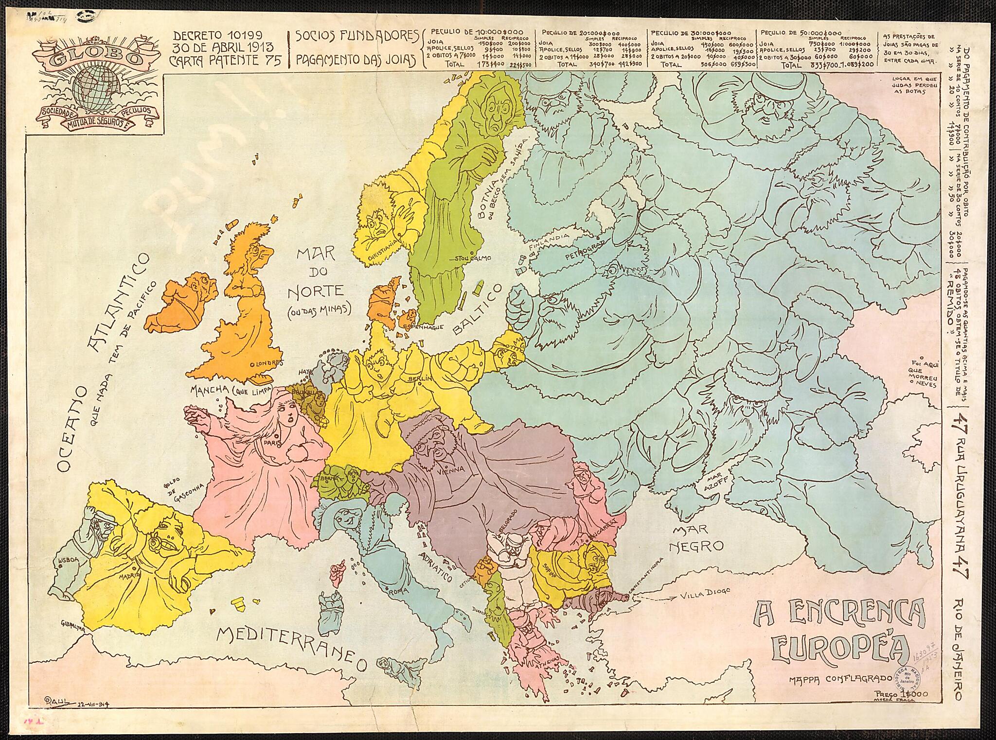
A Troubled Europe. Map of the Conflagration. (A Encrenca Européa Mappa Conflagrado) 1914
- Regular price
-
$82.95 - Regular price
-
$77.95 - Sale price
-
$82.95
Buy one map, get any other map in our collection for 50% OFF! Add to cart to see discount.
Couldn't load pickup availability
About This Map
Discover the timeless beauty of our fine art quality printed reproduction of this antique map. Perfect for history enthusiasts, collectors, and interior decorators.
Restored with meticulous attention to detail by our team with over a decade of experience, this stunning reproduction captures the intricate artistry and historical significance of the original map.
Whether you're a collector or seeking a unique decor piece, this archival-quality map reproduction is a timeless addition to any space. Order now to bring history to life!
Old map of Brazil.1953), a Brazilian illustrator, painter, caricaturist, author, and professor at the School of Fine Arts in the University of Rio de Janeiro. The countries of Europe are personified as male and female characters, most with angry faces and making threatening gestures toward their neighbors. The map was sponsored by Globo, a financial institution that offered loans, savings accounts, and insurance. The map reflects the keen interest with which people in Brazil, as in other countries, followed developments in Europe as the continent descended into war. Brazil was the only country in South America to declare war on Germany and the only country in Latin America to participate militarily in World War I. Like the United States, Brazil originally maintained strict neutrality in the conflict between the Allied and Central powers. However, in October 1917, following attacks by German submarines on Brazilian merchant ships, Brazil entered the war on the side of the Allies. The Brazilian army did not send troops to Europe, but the Brazilian navy helped to patrol the South Atlantic for German submarines. Brazil was also an important supplier of commodities to the Allies during the war.
Created by Raúl Pederneiras in 1914.
- Title devised, in English, by Library staff.
- Original resource extent: 1 map : color ; 40 x 58.5 centimeters.
- Original resource at: National Library of Brazil.
- Content in Portuguese.
- Description based on data extracted from World Digital Library, which may be extracted from partner institutions.
Map Subjects
Brazil
Caricatures And Cartoons
Pictorial Maps
World War
Raúl Pederneiras
1914
- For the best legibility, order your map in the original size or larger. Most maps have intricate detail and small text that is best appreciated when the print size hasn't been reduced.
- Sizes labeled "Fits a Standard Frame" will drop right into any frame that you purchase in that size. The sizes that we offer are commonly available online and at most retail stores.
- Our standard sizes are recommendations based on the aspect ratio of the original map, but still may require some added "white space" in one dimension to fit.
- Non-standard sizes will require custom framing, and we suggest taking your print to the frame shop of your choice after you receive it for the best results.
- Custom sizes are available, simply contact us for a quote.
Below is an approximation of the scale of a few standard sizes, and how they might appear in your space.

