
Africa, 1914. (Afrika)
- Regular price
-
$144.95 - Regular price
-
$139.95 - Sale price
-
$144.95
Buy one map, get any other map in our collection for 50% OFF! Add to cart to see discount.
Couldn't load pickup availability
About This Map
Discover the timeless beauty of our fine art quality printed reproduction of this antique map. Perfect for history enthusiasts, collectors, and interior decorators.
Restored with meticulous attention to detail by our team with over a decade of experience, this stunning reproduction captures the intricate artistry and historical significance of the original map.
Whether you're a collector or seeking a unique decor piece, this archival-quality map reproduction is a timeless addition to any space. Order now to bring history to life!
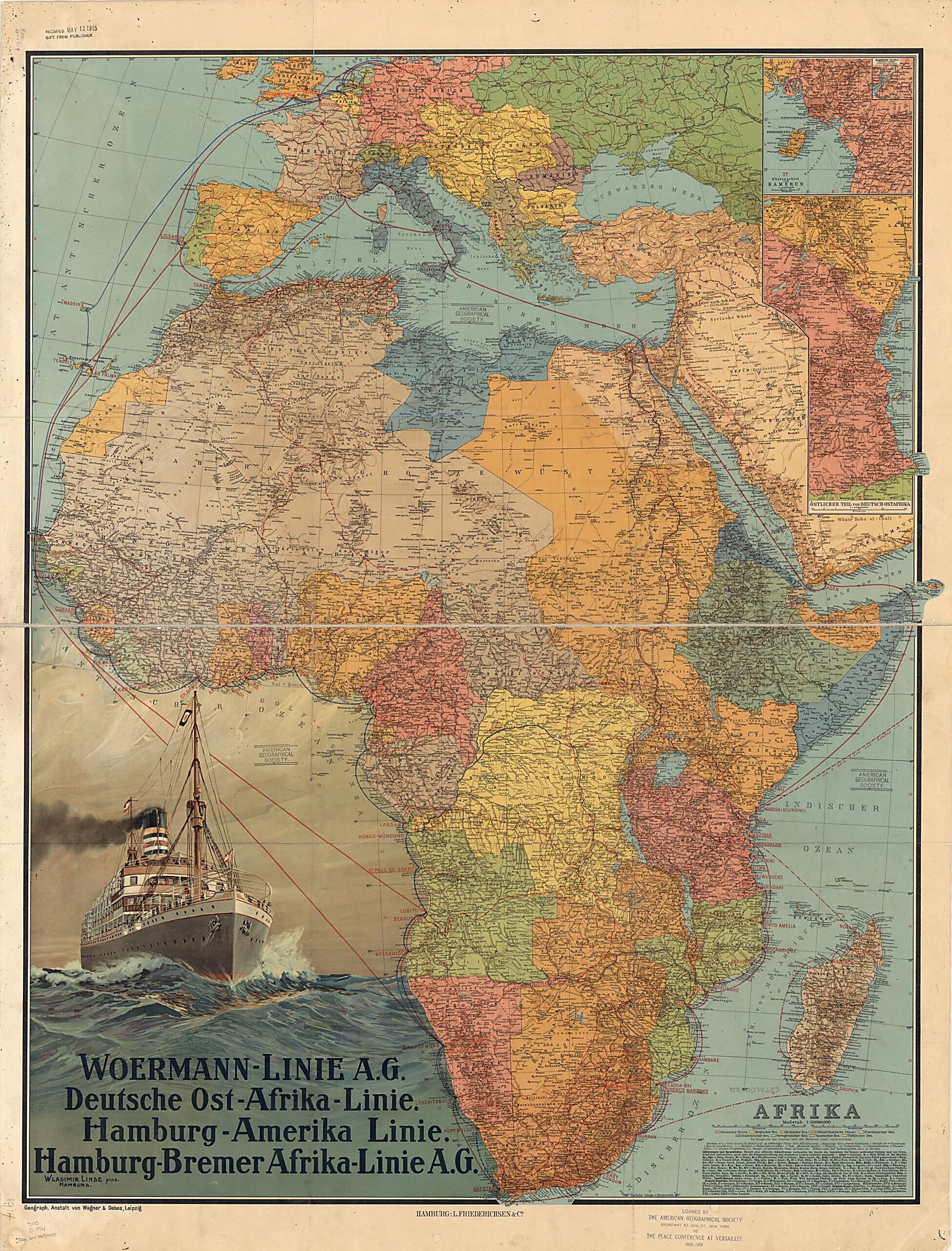
Linie A.G., Deutsche Ost-Afrika Linie, Hamburg-Amerika Linie, and Hamburg-Bremer Afrika-Linie A.G. In the upper right is an inset map of the coastal region of the German colony of Cameroon and an inset to the inset showing the inland course of the Cameroon River. Below these maps is another inset showing the eastern part of German East Africa. The key at the lower right indicates the wealth of information contained in the map. Two distance scales are provided, kilometers and nautical miles. Different colors are used to mark the colonial possessions of Germany, Great Britain, Belgium, France, Italy, Portugal, Spain, and Turkey. Symbols indicate cities and towns by population size, forts and military posts, ruins, railroads (operational and planned), caravan routes, mountain passes, wells and springs, and swamps and other geographic features. There is an alphabetical list of abbreviations for geographic terms in local languages and their German equivalents. Roman numerals are used to identify the districts and other administrative divisions in the Belgian Congo and German East Africa. The map was prepared by Wagner & Debes, a German firm that specialized in providing maps for inclusion in the famous guidebooks for travelers published by Karl Baedeker in the 19th and early 20th centuries. A stamp at the bottom indicates that the map was loaned by the American Geographical Society of New York to the Peace Conference at Versailles, 1918-19.Created by Vladimir V. Linde, Wagner & Debes in 1914.
- Title devised, in English, by Library staff.
- "Scale 1:10,000,000"--Note extracted from World Digital Library.
- Original resource extent: 1 map : color, mounted on linen ; 99 x 77 centimeters.
- Original resource at: University of Wisconsin-Milwaukee Libraries.
- Content in German.
- Description based on data extracted from World Digital Library, which may be extracted from partner institutions.
Map Subjects
Colonies
German East Africa Line (Shipping Firm)
Germany
Hamburg America Line (Shipping Firm)
Bremen Africa Line (Shipping Firm)
Ocean
Ships
Steamboat Lines
Tourism
Woermann Line (Shipping Firm)
World War
Vladimir V. Linde
Wagner & Debes
1914
- For the best legibility, order your map in the original size or larger. Most maps have intricate detail and small text that is best appreciated when the print size hasn't been reduced.
- Sizes labeled "Fits a Standard Frame" will drop right into any frame that you purchase in that size. The sizes that we offer are commonly available online and at most retail stores.
- Our standard sizes are recommendations based on the aspect ratio of the original map, but still may require some added "white space" in one dimension to fit.
- Non-standard sizes will require custom framing, and we suggest taking your print to the frame shop of your choice after you receive it for the best results.
- Custom sizes are available, simply contact us for a quote.
Below is an approximation of the scale of a few standard sizes, and how they might appear in your space.

