
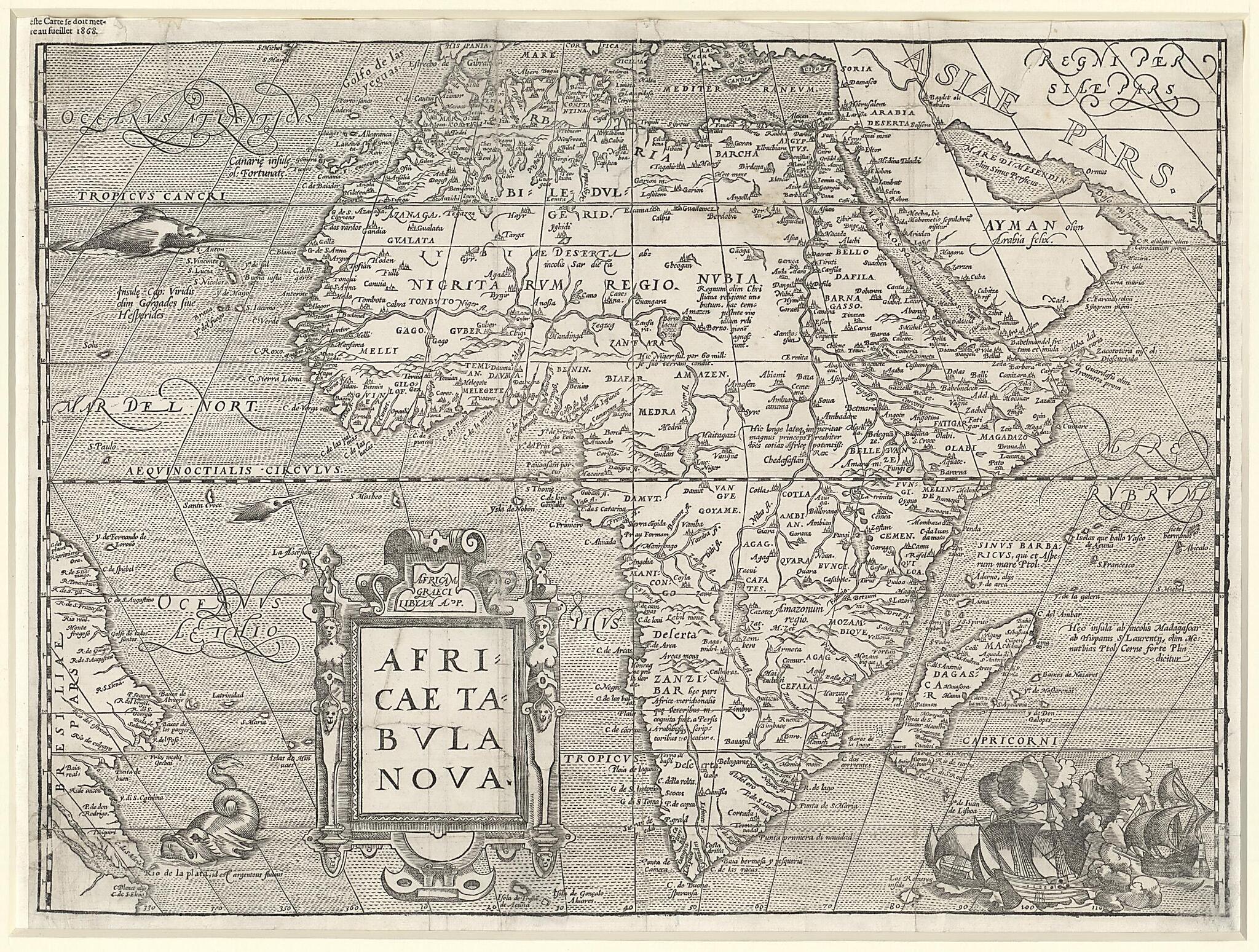
New Map of Africa. (Africae Tabvla Nova) 1575
- Regular price
-
$68.95 - Regular price
-
$63.95 - Sale price
-
$68.95
Buy one map, get any other map in our collection for 50% OFF! Add to cart to see discount.
Couldn't load pickup availability
About This Map
Discover the timeless beauty of our fine art quality printed reproduction of this antique map. Perfect for history enthusiasts, collectors, and interior decorators.
Restored with meticulous attention to detail by our team with over a decade of experience, this stunning reproduction captures the intricate artistry and historical significance of the original map.
Whether you're a collector or seeking a unique decor piece, this archival-quality map reproduction is a timeless addition to any space. Order now to bring history to life!
-98). The map is based on Giacomo Gastaldi's eight-sheet wall map of 1564 and on the 1569 world map by Gerhard Mercator and is the first to reflect accurately the knowledge gained by Europeans about the geography of the African continent from explorations of the previous century. The map remained highly influential until the 17th century. Ortelius introduced two changes from previous maps of Africa: he made the Cape of Good Hope more pointed and he reduced the eastward extension of the continent. The map includes, in the correct locations, place names that are still in use today, for example Mozambique, Benin, and Congo. It also employs more general terms, such as "Nigritarum Regio" (Kingdom of the Blacks). Theatrum orbis terrarum is considered the first true atlas in the modern sense: a collection of uniform map sheets and accompanying text bound to form a book for which copper printing plates were specifically engraved. The first edition was followed by other versions in Latin, Dutch, French, German, and Spanish, with an ever-increasing number of maps. Between 1570 and 1612, the atlas was issued in 31 editions and seven languages. The map shown here is from the fifth Latin edition, published in 1575. As with many other maps in the atlas, it was engraved by Frans Hogenberg (circa 1539-90).Created by Giacomo Gastaldi, Franz Hogenberg, Gerhard Mercator, Abraham Ortelius in 1575.
- Title devised, in English, by Library staff.
- Original resource extent: 1 map ; 36 x 49 centimeters.
- Reference extracted from World Digital Library: "Revealing the African Presence in Renaissance Europe," at the Walters Art Museum, Baltimore. http://issuu.com/the-walters-art-museum/docs/singlepages3429_african_presence_10/11.|"Ortelius External Atlas," at https://memory.loc.gov/ammem/gmdhtml/gnrlort.html
- Original resource at: Qatar National Library.
- Content in Latin.
- Description based on data extracted from World Digital Library, which may be extracted from partner institutions.
Map Subjects
Giacomo Gastaldi
Franz Hogenberg
Gerhard Mercator
Abraham Ortelius
1575
- For the best legibility, order your map in the original size or larger. Most maps have intricate detail and small text that is best appreciated when the print size hasn't been reduced.
- Sizes labeled "Fits a Standard Frame" will drop right into any frame that you purchase in that size. The sizes that we offer are commonly available online and at most retail stores.
- Our standard sizes are recommendations based on the aspect ratio of the original map, but still may require some added "white space" in one dimension to fit.
- Non-standard sizes will require custom framing, and we suggest taking your print to the frame shop of your choice after you receive it for the best results.
- Custom sizes are available, simply contact us for a quote.
Below is an approximation of the scale of a few standard sizes, and how they might appear in your space.

