
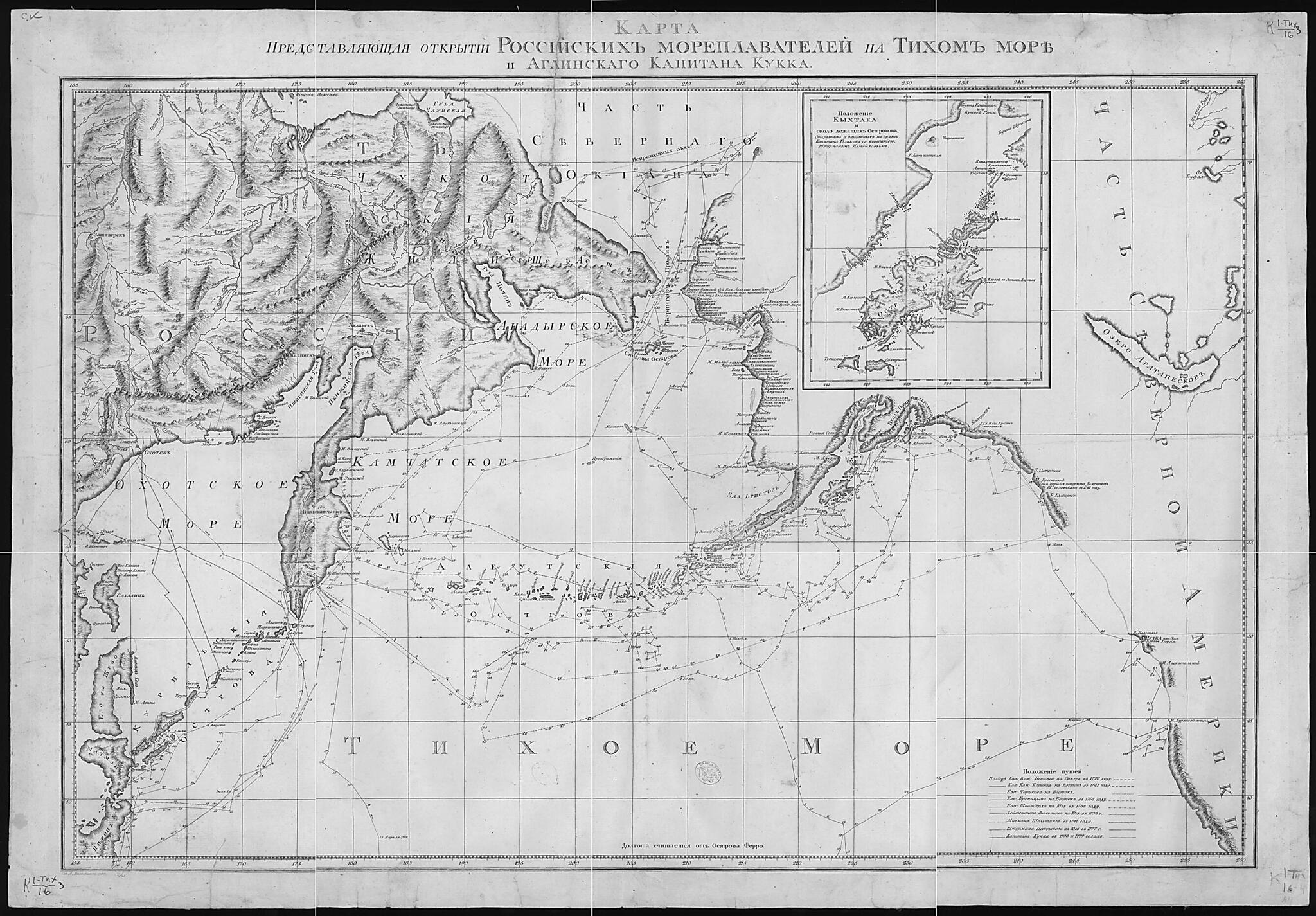
Karta Predstavli︠a︡i︠u︡shchai︠a︡ Otkrytii︠a︡ Rossiĭskikh Moreplavateleĭ Na Tikhom Okeane I Angliĭskogo Kapitana Kukka. (Карта представляющая открытия Российских мореплавателей на ...
- Regular price
-
$91.95 - Regular price
-
$86.95 - Sale price
-
$91.95
Buy one map, get any other map in our collection for 50% OFF! Add to cart to see discount.
Couldn't load pickup availability
About This Map
Discover the timeless beauty of our fine art quality printed reproduction of this antique map. Perfect for history enthusiasts, collectors, and interior decorators.
Restored with meticulous attention to detail by our team with over a decade of experience, this stunning reproduction captures the intricate artistry and historical significance of the original map.
Whether you're a collector or seeking a unique decor piece, this archival-quality map reproduction is a timeless addition to any space. Order now to bring history to life!
Old map of Alaska, Chukotka Autonomous Okrug, Kamchatka Krai, Russian Federation, United States.79 voyage of British Captain James Cook. The route of each voyage is depicted in great detail, with ship locations plotted by the day. Other details on the map include administrative borders, population centers, Chukchi dwellings, and impassable ice. The inset map is of Kodiak Island, Alaska, denoted here by its Russian name of Kykhtak. World Digital Library.
Created by Alexander Wilbrecht in 1787.
- Dop. karta: Polozhenie Kykhtaka i okolo lezhashchikh ostrovov, otkrytykh i opisannykh na sudne kapitana Golikova s kompaniei︠u︡, shturmanom G.A.Izmailovym.
- Pokazany marshruty puteshestviĭ: kapitana V.I.Beringa na sever v 1728g. i na vostok v 1741g., kapitana P.Chirikova na vostok, kapitana P.K.Krenit︠s︡ina na vostok v 1768g., kapitana M.P.Shpanberga na i︠u︡g v 1738g., leĭtenanta Val'tona na i︠u︡g v 1777g., michmana A.E.Shel'tinga v 1741g., shturmana Petushkova na i︠u︡g v 1777g., kapitana D. Kuka v 1778-1779gg., ezhednevnye mesta nakhozhdenii︠a︡ sudov; adm. granit︠s︡y, otd. nasel. punkty, chukotskie zhilishcha; neprokhodimye l'dy, rel'ef perspekt. risunkom i shtrikhami.Karta okhvatyvaet akvatorii︠u︡ Tikhogo okeana k severu ot ėkvatora i pribrezhnye chasti Azii i Severnoĭ Ameriki.
- Original map at: National Library of Russia
- Доп. карта: Положение Кыхтака и около лежащих островов, открытых и описанных на судне капитана Голикова с компаниею, штурманом Г.А.Измаиловым.
- Показаны маршруты путешествий: капитана В.И.Беринга на север в 1728г. и на восток в 1741г., капитана П.Чирикова на восток, капитана П.К.Креницина на восток в 1768г., капитана М.П.Шпанберга на юг в 1738г., лейтенанта Вальтона на юг в 1777г., мичмана А.Е.Шельтинга в 1741г., штурмана Петушкова на юг в 1777г., капитана Д. Кука в 1778-1779гг., ежедневные места нахождения судов; адм. границы, отд. насел. пункты, чукотские жилища; непроходимые льды, рельеф перспект. рисунком и штрихами.Карта охватывает акваторию Тихого океана к северу от экватора и прибрежные части Азии и Северной Америки.
Map Subjects
Alaska
Bering Vitus
Chirikov Alekseĭ Il'ich.
Chukotka Autonomous Okrug
Cook James
Exploration And Encounters
Explorers
Izmailov G.A. Ėkspedit︠s︡ii︠a
Kamchatka Krai
Kuk,dzheĭms () Golikov,ėkspedit︠s︡ii︠a
Russian Federation
Shel'ting A.E.() Ėkspedit︠s︡ii︠a
Shpanberg,martyn Petrovich (Um.) Val'ton Ėkspedit︠s︡ii 1777
Siberia
United States Of America
Voyages And Travels
Шпанберг,мартын Петрович (Ум.) Вальтон Экспедиции 1777
United States
Alexander Wilbrecht
1787
- For the best legibility, order your map in the original size or larger. Most maps have intricate detail and small text that is best appreciated when the print size hasn't been reduced.
- Sizes labeled "Fits a Standard Frame" will drop right into any frame that you purchase in that size. The sizes that we offer are commonly available online and at most retail stores.
- Our standard sizes are recommendations based on the aspect ratio of the original map, but still may require some added "white space" in one dimension to fit.
- Non-standard sizes will require custom framing, and we suggest taking your print to the frame shop of your choice after you receive it for the best results.
- Custom sizes are available, simply contact us for a quote.
Below is an approximation of the scale of a few standard sizes, and how they might appear in your space.
