
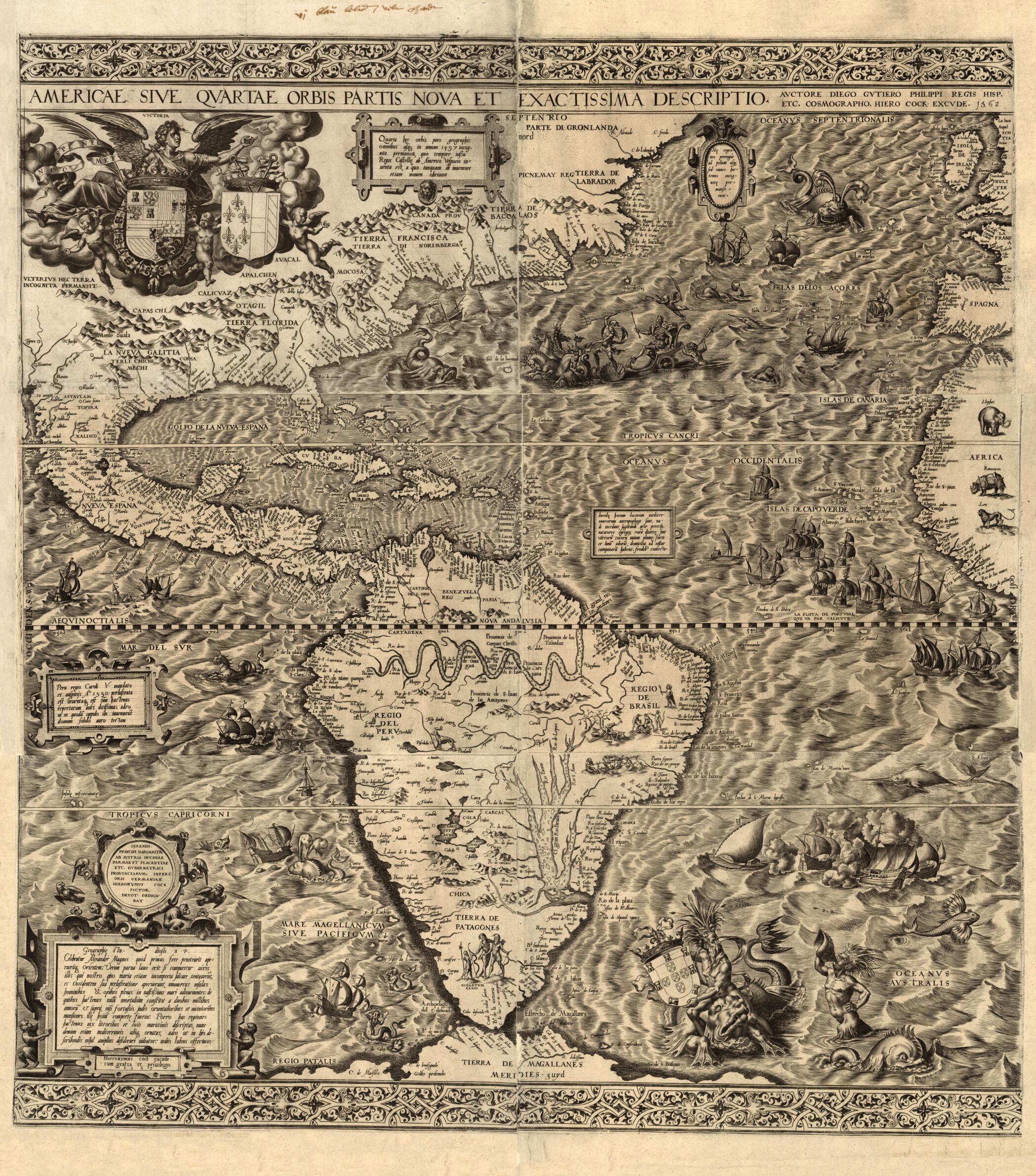
Americae Sive Qvartae Orbis Partis Nova Et Exactissima Descriptio (Americae Sive Quartae Orbis Partis Nova Et Exactissima Descriptio) 1562
- Regular price
-
$142.95 - Regular price
-
$137.95 - Sale price
-
$142.95
Buy one map, get any other map in our collection for 50% OFF! Add to cart to see discount.
Couldn't load pickup availability
About This Map
Discover the timeless beauty of our fine art quality printed reproduction of this antique map. Perfect for history enthusiasts, collectors, and interior decorators.
Restored with meticulous attention to detail by our team with over a decade of experience, this stunning reproduction captures the intricate artistry and historical significance of the original map.
Whether you're a collector or seeking a unique decor piece, this archival-quality map reproduction is a timeless addition to any space. Order now to bring history to life!
Old map of America, Western Hemisphere.Created by Hieronymus Cock, Diego Gutiérrez, Lessing J. Rosenwald Collection (Library of Congress) in 1562.
- Covers North and South America with the adjacent seas.
- Relief shown pictorially.
- From the Rosenwald Collection, Library of Congress, no. 1303.
- Originally printed on 6 sheets.
- Described in Quarterly Journal of the Library of Congress, v. 6, no. 3 (May 1949), p. 18-20.
- Library of Congress. Lessing J. Rosenwald collection, 1303
- Includes texts in cartouche, statements of dedication, coats-of-arms, ill. of allegorical figure "Victoria", and ill. of sailing ships at sea and imaginary marine creatures.
- LAC scc 2019-07-10 update (1 card)
- Card copy 1 reviewed part of Rosenwald Coll per shelflist card. HREC has G & M.LAC scc 2019-07-10
- For the best legibility, order your map in the original size or larger. Most maps have intricate detail and small text that is best appreciated when the print size hasn't been reduced.
- Sizes labeled "Fits a Standard Frame" will drop right into any frame that you purchase in that size. The sizes that we offer are commonly available online and at most retail stores.
- Our standard sizes are recommendations based on the aspect ratio of the original map, but still may require some added "white space" in one dimension to fit.
- Non-standard sizes will require custom framing, and we suggest taking your print to the frame shop of your choice after you receive it for the best results.
- Custom sizes are available, simply contact us for a quote.
Below is an approximation of the scale of a few standard sizes, and how they might appear in your space.

