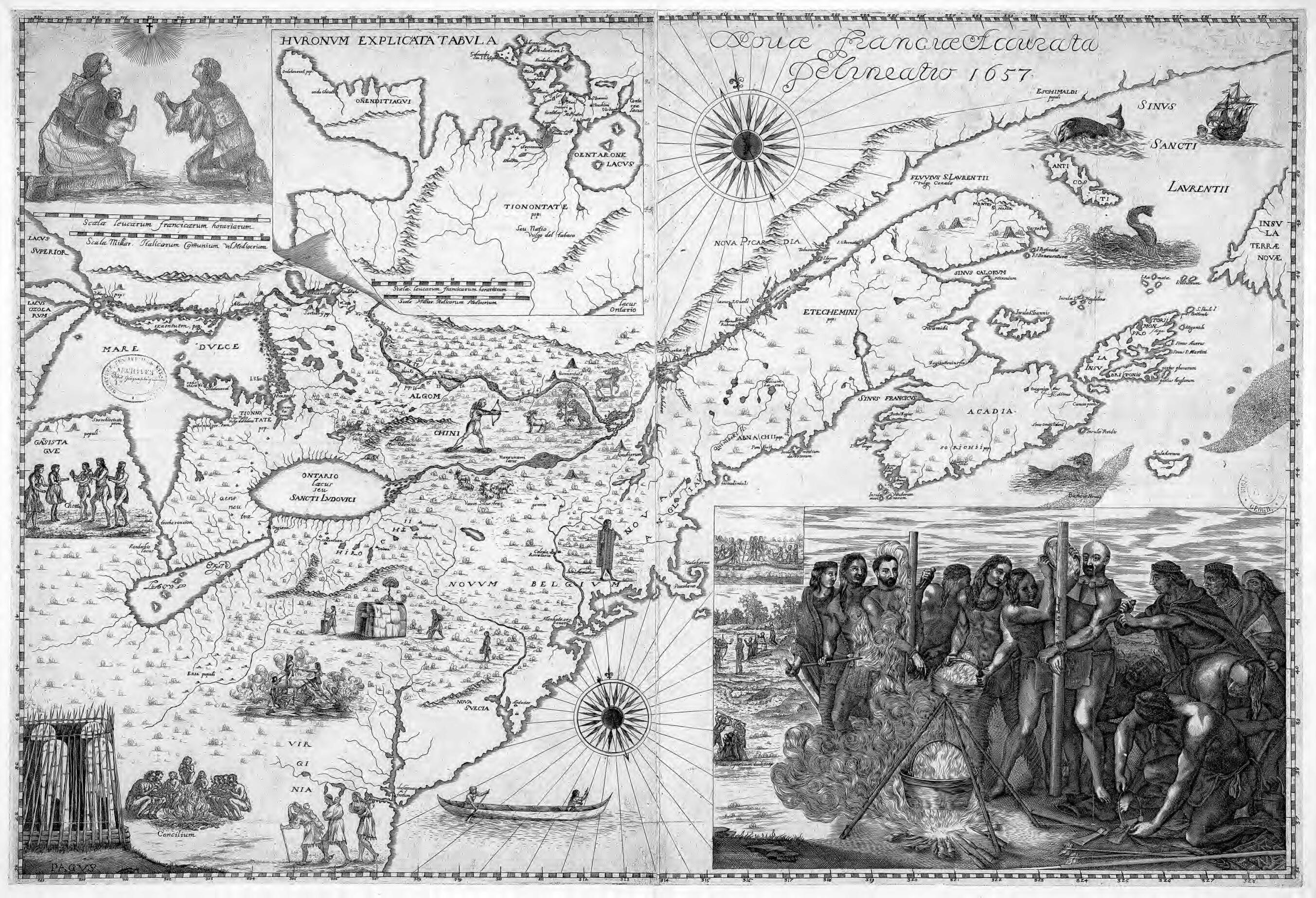
An Accurate Depiction of New France, 1657. (Novae Franciae Accurata Delineatio, 1657)
- Regular price
-
$31.95 - Regular price
-
$49.95 - Sale price
-
$31.95
Ships for FREE
Limited Time: Buy one map, get one map 50% off! Discount shown in cart.
Couldn't load pickup availability
90-Day Satisfaction Guarantee, Free Returns & Lifetime Warranty
About This Map
Discover the timeless beauty of our fine art quality printed reproduction of this antique map. Perfect for history enthusiasts, collectors, and interior decorators.
Restored with meticulous attention to detail by our team with over a decade of experience, this stunning reproduction captures the intricate artistry and historical significance of the original map.
Whether you're a collector or seeking a unique decor piece, this archival-quality map reproduction is a timeless addition to any space. Order now to bring history to life!
Old map of Canada, Connecticut, District of Columbia, Indiana, Kentucky, Maine, Maryland, Massachusetts, Michigan, New Brunswick, New Hampshire, New Jersey, New York, Nova Scotia, Ohio, Ontario, Pennsylvania, Quebec, Rhode Island, United States of America, Vermont, Virginia, Washington, West Virginia.72), who was sent as a missionary to the Huron Indians in 1642. In 1653 he published in his native Italy an account of his stay in New France in which he announced the impending publication of a map, also based on his time in North America. The map shown here, from the National Library of France, is one of only two known copies of Bressani's map. It represents the Great Lakes region with remarkable accuracy. An inset map at the top center shows the Huron country. The map also contains illustrations related to Bressani's mission and intended for the edification of the faithful. In the lower right is a scene of the martyrdom in 1649 of priests Jean de Brébeuf and Gabriel Lalemant. In the upper left is a portrait of an Indian family in prayer. Illustrations on the map depict Indian villages, a canoe, animals and hunting, and other scenes. The Dutch and English colonies of New Amsterdam and New England are indicated by their Latin names, Novum Belgium and Nova Anglia. Scale is given in French leagues and Italian miles. The map is from the collection of the geographer Jean-Baptiste Bourguignon d'Anville (1697--1782). It was given to King Louis XVI in 1782 and deposited in the National Library of France in 1924.
Created by Francesco Giuseppe Bressani in 1657.
- Title devised, in English, by Library staff.
- Original resource extent: 1 map ; 51.5 x 75.5 centimeters.
- Original resource at: National Library of France.
- Content in Latin.
- Description based on data extracted from World Digital Library, which may be extracted from partner institutions.
Map Tags
1657
Brébeuf Jean De Saint
Canada
Catholic Church
Colonies
Connecticut
District Of Columbia
France
France In America
Francesco Giuseppe Bressani
Great Lakes Region (North America)
Indiana
Indians Of South America
Indigenous Peoples
Iroquois Indians
Jesuits
Kentucky
Lalemant Gabriel Saint
Maine
Map
Martyrdom
Maryland
Massachusetts
Michigan
Missionaries
Missions
New Brunswick
New France
New Hampshire
New Jersey
New York
Nova Scotia
Ohio
Ontario
Pennsylvania
Quebec
Rhode Island
United States Of America
Vermont
Virginia
Washington
West Virginia
Wyandot Indians

- For the best legibility, order your map in the original size or larger. Most maps have intricate detail and small text that is best appreciated when the print size hasn't been reduced.
- Sizes labeled "Fits a Standard Frame" will drop right into any frame that you purchase in that size. The sizes that we offer are commonly available online and at most retail stores.
- Our standard sizes are recommendations based on the aspect ratio of the original map, but still may require some added "white space" in one dimension to fit.
- Non-standard sizes will require custom framing, and we suggest taking your print to the frame shop of your choice after you receive it for the best results.
- Custom sizes are available, simply contact us for a quote.
Below is an approximation of the scale of a few standard sizes, and how they might appear in your space.


