
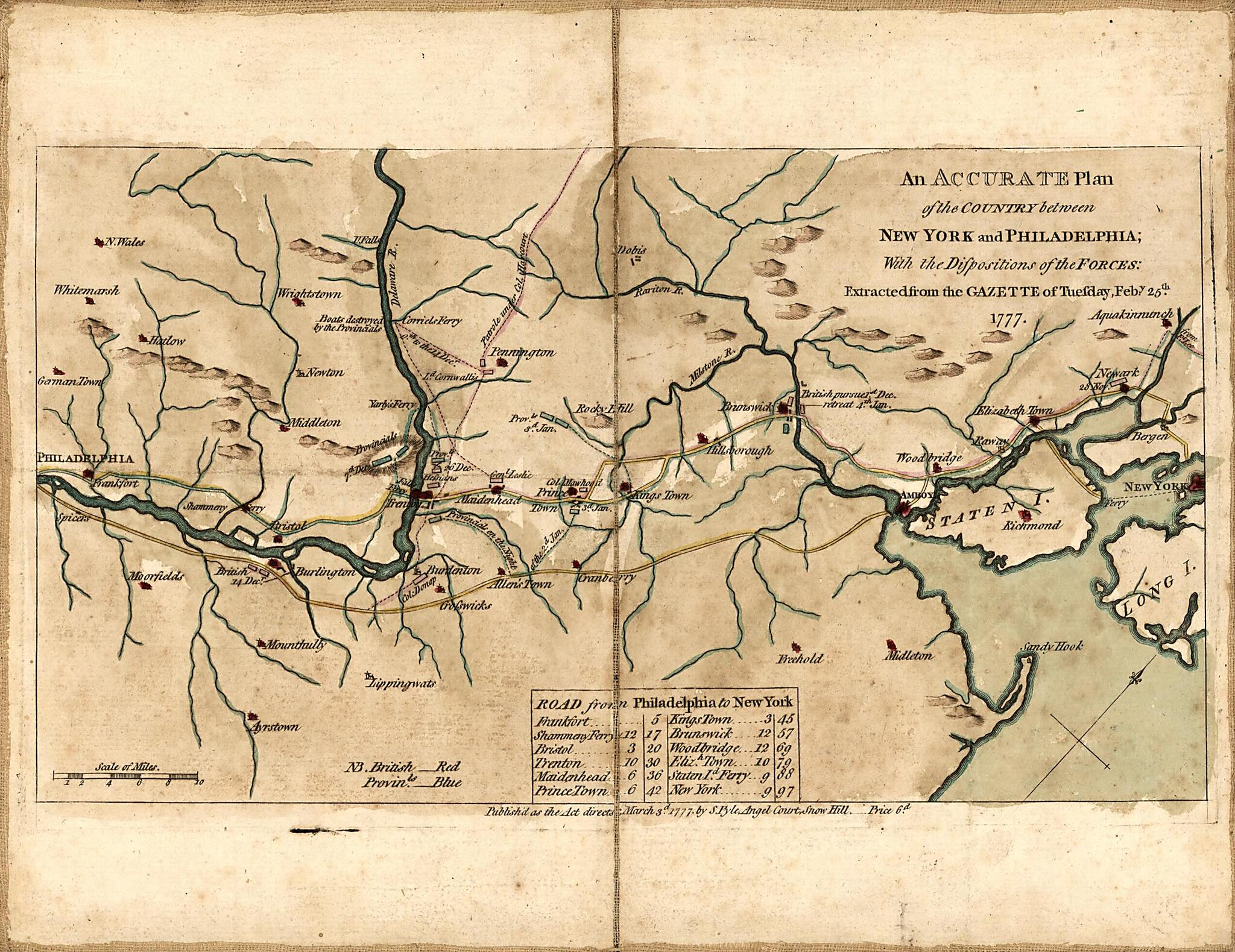
An Accurate Plan of the Country Between New York and Philadelphia : With the Dispositions of the Forces. (York à Philadelphie En 1777 :)
- Regular price
-
$49.95 - Regular price
-
$34.95 - Sale price
-
$49.95
Buy one map, get any other map in our collection for 50% OFF! Add to cart to see discount.
Couldn't load pickup availability
About This Map
Discover the timeless beauty of our fine art quality printed reproduction of this antique map. Perfect for history enthusiasts, collectors, and interior decorators.
Restored with meticulous attention to detail by our team with over a decade of experience, this stunning reproduction captures the intricate artistry and historical significance of the original map.
Whether you're a collector or seeking a unique decor piece, this archival-quality map reproduction is a timeless addition to any space. Order now to bring history to life!
Old map of New Jersey, New York, New York (State), New York Region, Pennsylvania, Philadelphia Region, United States.Created by Stephen Pyle in 1777.
- Shows positions of British (red) and American (blue) forces along the major highways between New York City and Philadelphia.
- Relief shown pictorially.
- At foot of title: Extracted from the Gazette of Tuesday, Feb'y 25th 1777.
- "Published as the Act directs March 3d 1777 by S. Pyle, Angel Court, Snow Hill--price 6d."
- Oriented with north toward the upper right.
- Includes distance table.
Map Subjects
Campaigns
Early Works To 1800
History
New Jersey
New York (State)
New York Region
New York Region (N.Y.)
Pennsylvania
Philadelphia Region
Philadelphia Region (Pa.)
Revolution
Roads
United States
New York
Stephen Pyle
1777
- For the best legibility, order your map in the original size or larger. Most maps have intricate detail and small text that is best appreciated when the print size hasn't been reduced.
- Sizes labeled "Fits a Standard Frame" will drop right into any frame that you purchase in that size. The sizes that we offer are commonly available online and at most retail stores.
- Our standard sizes are recommendations based on the aspect ratio of the original map, but still may require some added "white space" in one dimension to fit.
- Non-standard sizes will require custom framing, and we suggest taking your print to the frame shop of your choice after you receive it for the best results.
- Custom sizes are available, simply contact us for a quote.
Below is an approximation of the scale of a few standard sizes, and how they might appear in your space.

