
Arabia 1860
- Regular price
-
$52.95 - Regular price
-
$36.95 - Sale price
-
$52.95
Buy one map, get any other map in our collection for 50% OFF! Add to cart to see discount.
Couldn't load pickup availability
About This Map
Discover the timeless beauty of our fine art quality printed reproduction of this antique map. Perfect for history enthusiasts, collectors, and interior decorators.
Restored with meticulous attention to detail by our team with over a decade of experience, this stunning reproduction captures the intricate artistry and historical significance of the original map.
Whether you're a collector or seeking a unique decor piece, this archival-quality map reproduction is a timeless addition to any space. Order now to bring history to life!
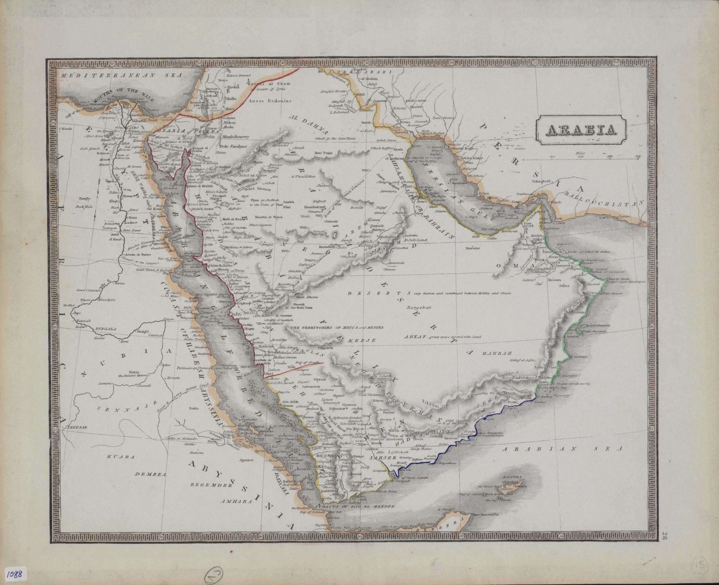
Old map of Bahrain, Djibouti, Egypt, Eritrea, Ethiopia, Iran, Islamic Republic of, Iraq, Israel, Jordan, Kuwait, Lebanon, Oman, Qatar, Saudi Arabia, Somalia, Sudan, Syrian Arab Republic, United Arab Emirates, Yemen.19th-century British map shows the Arabian Peninsula and neighboring parts of Africa, including Egypt, the Sudan, and Abyssinia. The traditional Greek and Roman division of Arabia into the three parts of Arabia Petraea, Arabia Deserta, and Arabia Felix is used. Qatar is shown as Catura. Also indicated are Oman, Bahrain, and the territories of Mecca and Medina. The map emphasizes the vast, empty interior of the peninsula with such annotations as "great space covered with sand" and "deserts very barren and continued between Mekka and Oman." Four different caravan routes for pilgrims to the city of Mecca are shown: the Damascus route from the north; the Turkish and African route across the Sinai Peninsula; the Persian route to the northeast; and the Indian route to a port on the Persian Gulf. The locations of water wells along the Persian and Indian caravan routes are indicated.
- Title devised, in English, by Library staff.
- "Scale approximately 1:10,000,000"--Note extracted from World Digital Library.
- Original resource extent: 1 map : color ; 22 x 32 centimeters.
- Original resource at: Qatar National Library.
- Content in English.
- Description based on data extracted from World Digital Library, which may be extracted from partner institutions.
- For the best legibility, order your map in the original size or larger. Most maps have intricate detail and small text that is best appreciated when the print size hasn't been reduced.
- Sizes labeled "Fits a Standard Frame" will drop right into any frame that you purchase in that size. The sizes that we offer are commonly available online and at most retail stores.
- Our standard sizes are recommendations based on the aspect ratio of the original map, but still may require some added "white space" in one dimension to fit.
- Non-standard sizes will require custom framing, and we suggest taking your print to the frame shop of your choice after you receive it for the best results.
- Custom sizes are available, simply contact us for a quote.
Below is an approximation of the scale of a few standard sizes, and how they might appear in your space.

