

Arabia 1850
- Regular price
-
$49.95 - Regular price
-
$34.95 - Sale price
-
$49.95
Buy one map, get any other map in our collection for 50% OFF! Add to cart to see discount.
Couldn't load pickup availability
About This Map
Discover the timeless beauty of our fine art quality printed reproduction of this antique map. Perfect for history enthusiasts, collectors, and interior decorators.
Restored with meticulous attention to detail by our team with over a decade of experience, this stunning reproduction captures the intricate artistry and historical significance of the original map.
Whether you're a collector or seeking a unique decor piece, this archival-quality map reproduction is a timeless addition to any space. Order now to bring history to life!
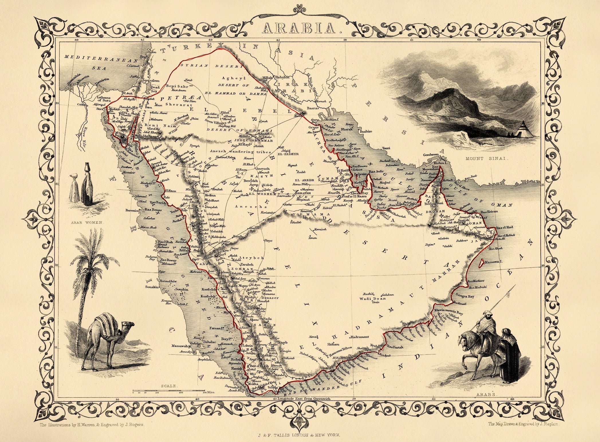
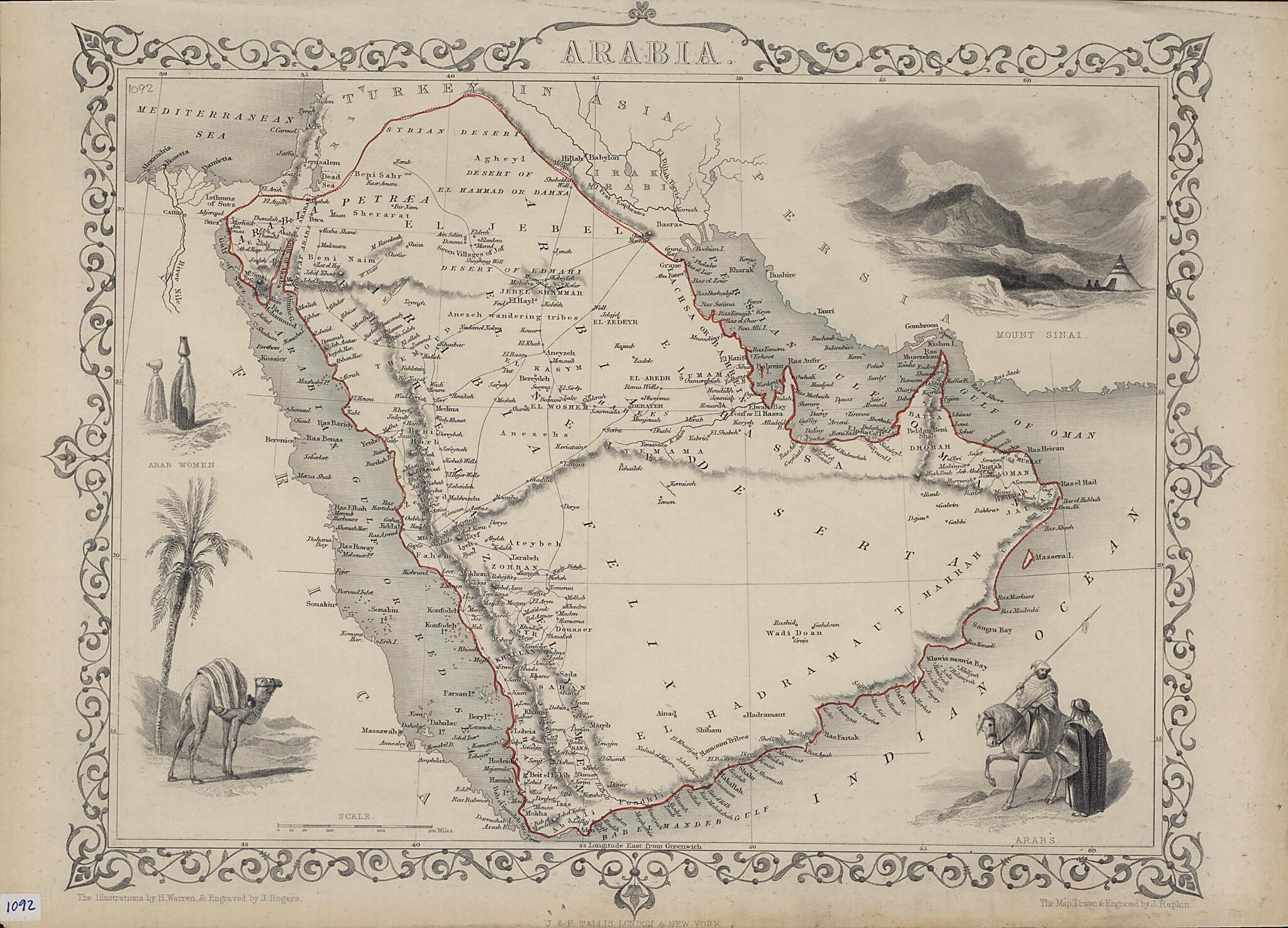
Old map of Bahrain, Egypt, Iraq, Israel, Jordan, Kuwait, Oman, Qatar, Saudi Arabia, United Arab Emirates, Yemen.-76), which was active in London circa 1835-60. Tallis maps were known for their accurate information with numerous place-names and geographical details, as well as for the use of shaded areas to indicate topographical features. They are identifiable by the scrolling on the borders and the finely-drawn scenes inscribed on the margins of the maps, which John Tallis and his illustrators derived from travelogues and other written sources. John Rapkin (1815-76) was the principal engraver for the firm, who drew and engraved most Tallis maps. This map of Arabia by Rapkin shows physical features, towns and villages, and caravan routes across the desert, many leading to the holy city of Mecca. The geographic extent of the region defined as Arabia is marked with a red line, and includes not only the Arabian Peninsula but parts of present-day Egypt, Jordan, and Syria. Illustrations in the four corners of the map show a camel beneath a palm tree, Arab women carrying water jars, Mount Sinai, and two Arab men, one on horseback and another on foot. The illustrations were drawn by H. Warren and engraved by John Rogers, who produced numerous steel engravings for Tallis.
Created by John Rapkin, John Rogers, H. Warren in 1850.
- Title devised, in English, by Library staff.
- Original resource extent: 1 map ; 26x 32 centimeters.
- Original resource at: Qatar National Library.
- Content in English.
- Description based on data extracted from World Digital Library, which may be extracted from partner institutions.
Map Subjects
Arabian Gulf
Arabian Peninsula
Bahrain
Egypt
Iraq
Israel
Jordan
Kuwait
Oman
Persian Gulf
Qatar
Red Sea
Saudi Arabia
United Arab Emirates
Yemen
John Rapkin
John Rogers
H. Warren
1850
- For the best legibility, order your map in the original size or larger. Most maps have intricate detail and small text that is best appreciated when the print size hasn't been reduced.
- Sizes labeled "Fits a Standard Frame" will drop right into any frame that you purchase in that size. The sizes that we offer are commonly available online and at most retail stores.
- Our standard sizes are recommendations based on the aspect ratio of the original map, but still may require some added "white space" in one dimension to fit.
- Non-standard sizes will require custom framing, and we suggest taking your print to the frame shop of your choice after you receive it for the best results.
- Custom sizes are available, simply contact us for a quote.
Below is an approximation of the scale of a few standard sizes, and how they might appear in your space.

