
Arabia: With the Adjacent Countries of Egypt and Nubia. (Arabia : With the Adjacent Countries of Egypt & Nubia) 1831
- Regular price
-
$110.95 - Regular price
-
$105.95 - Sale price
-
$110.95
Buy one map, get any other map in our collection for 50% OFF! Add to cart to see discount.
Couldn't load pickup availability
About This Map
Discover the timeless beauty of our fine art quality printed reproduction of this antique map. Perfect for history enthusiasts, collectors, and interior decorators.
Restored with meticulous attention to detail by our team with over a decade of experience, this stunning reproduction captures the intricate artistry and historical significance of the original map.
Whether you're a collector or seeking a unique decor piece, this archival-quality map reproduction is a timeless addition to any space. Order now to bring history to life!
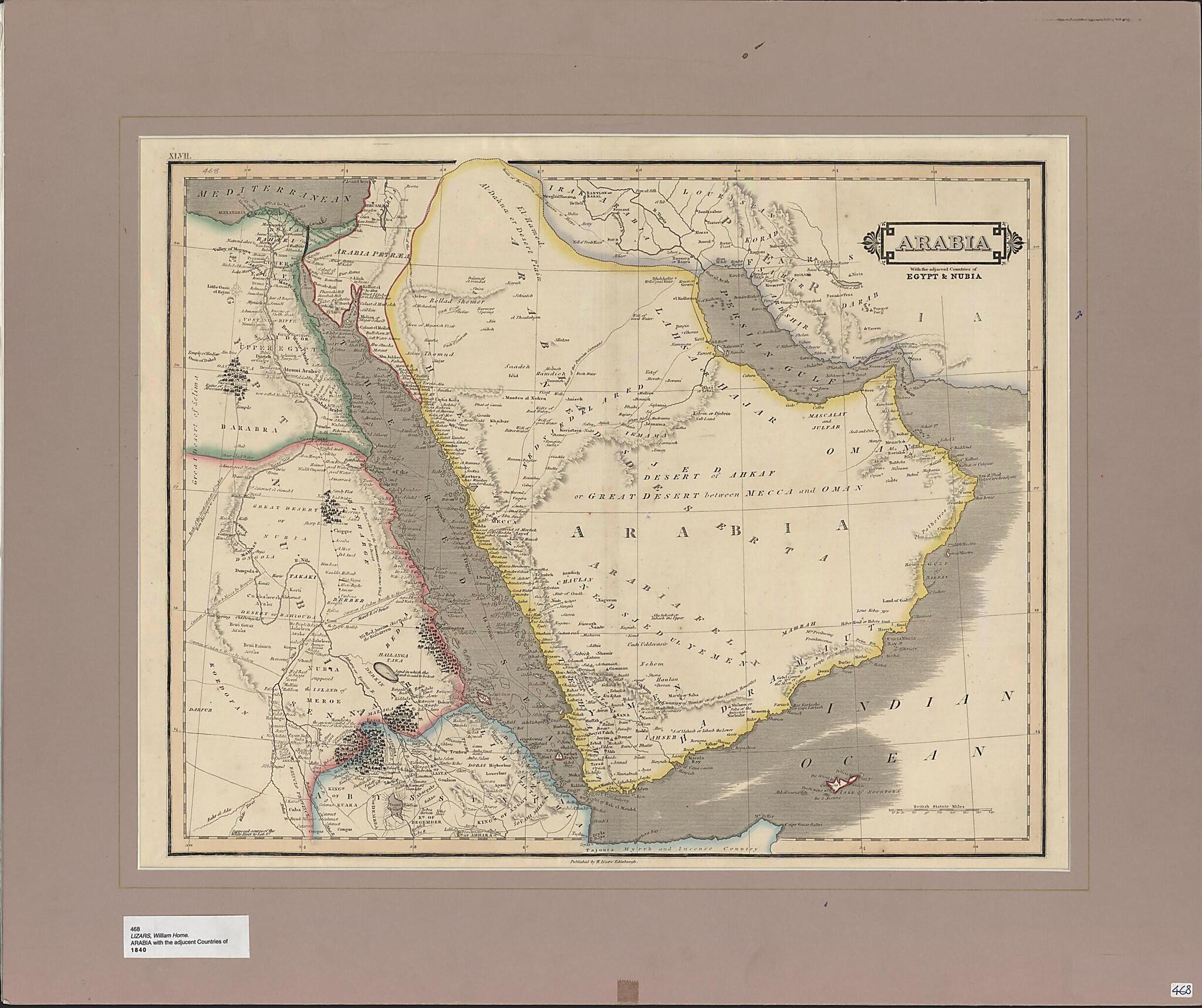
Old map of Bahrain, Egypt, Eritrea, Ethiopia, Iran, Islamic Republic of, Iraq, Israel, Jordan, Kuwait, Oman, Qatar, Saudi Arabia, Somalia, Sudan, United Arab Emirates, Yemen.1859) was a Scottish engraver and painter and the son of the engraver Daniel Lizars. This map appears identical to the one engraved by Daniel, which appeared in The Edinburgh Geographical and Historical Atlas published by John Hamilton in 1831. It is plate 47 of the atlas. Relief is shown by hachures, and scale is indicated in British statute miles. The map shows towns and other settlements, oases, caravan routes to Mecca from different directions, and other geographic features. Present-day Jordan, Israel, and Sinai are labeled as Arabia Petraea; present-day Sudan is identified as Nubia; Eritrea and Ethiopia are marked Abyssina; and northern Somalia is called Myrrh and Incense Country. The Red Sea islands of Dahlak and Jabal Zuqar (labeled Gebel Zeghir) are disproportionately large. Qatar is marked on the map as Catura and a tiny hint of the Qatar Peninsula can be seen on the map. Previously this region of the northern shore of Arabia was depicted as flat and it had only begun to be mapped at the very time of the publication of the original map made by Daniel Lizars. The pearl banks in the region of Qatar are also labeled.
Created by Daniel Lizars, W.H. (William Home) Lizars in 1831.
- Title devised, in English, by Library staff.
- Original resource extent: 1 map : hand colored ; 39 x 50 centimeters.
- Original resource at: Qatar National Library.
- Content in English.
- Description based on data extracted from World Digital Library, which may be extracted from partner institutions.
Map Subjects
Arabian Gulf
Arabian Peninsula
Bahrain
Egypt
Eritrea
Ethiopia
Iran Islamic Republic Of
Iraq
Israel
Jordan
Kuwait
Oman
Persian Gulf
Qatar
Red Sea
Saudi Arabia
Somalia
Sudan
United Arab Emirates
Yemen
Daniel Lizars
W.H. (William Home) Lizars
1831
- For the best legibility, order your map in the original size or larger. Most maps have intricate detail and small text that is best appreciated when the print size hasn't been reduced.
- Sizes labeled "Fits a Standard Frame" will drop right into any frame that you purchase in that size. The sizes that we offer are commonly available online and at most retail stores.
- Our standard sizes are recommendations based on the aspect ratio of the original map, but still may require some added "white space" in one dimension to fit.
- Non-standard sizes will require custom framing, and we suggest taking your print to the frame shop of your choice after you receive it for the best results.
- Custom sizes are available, simply contact us for a quote.
Below is an approximation of the scale of a few standard sizes, and how they might appear in your space.

