
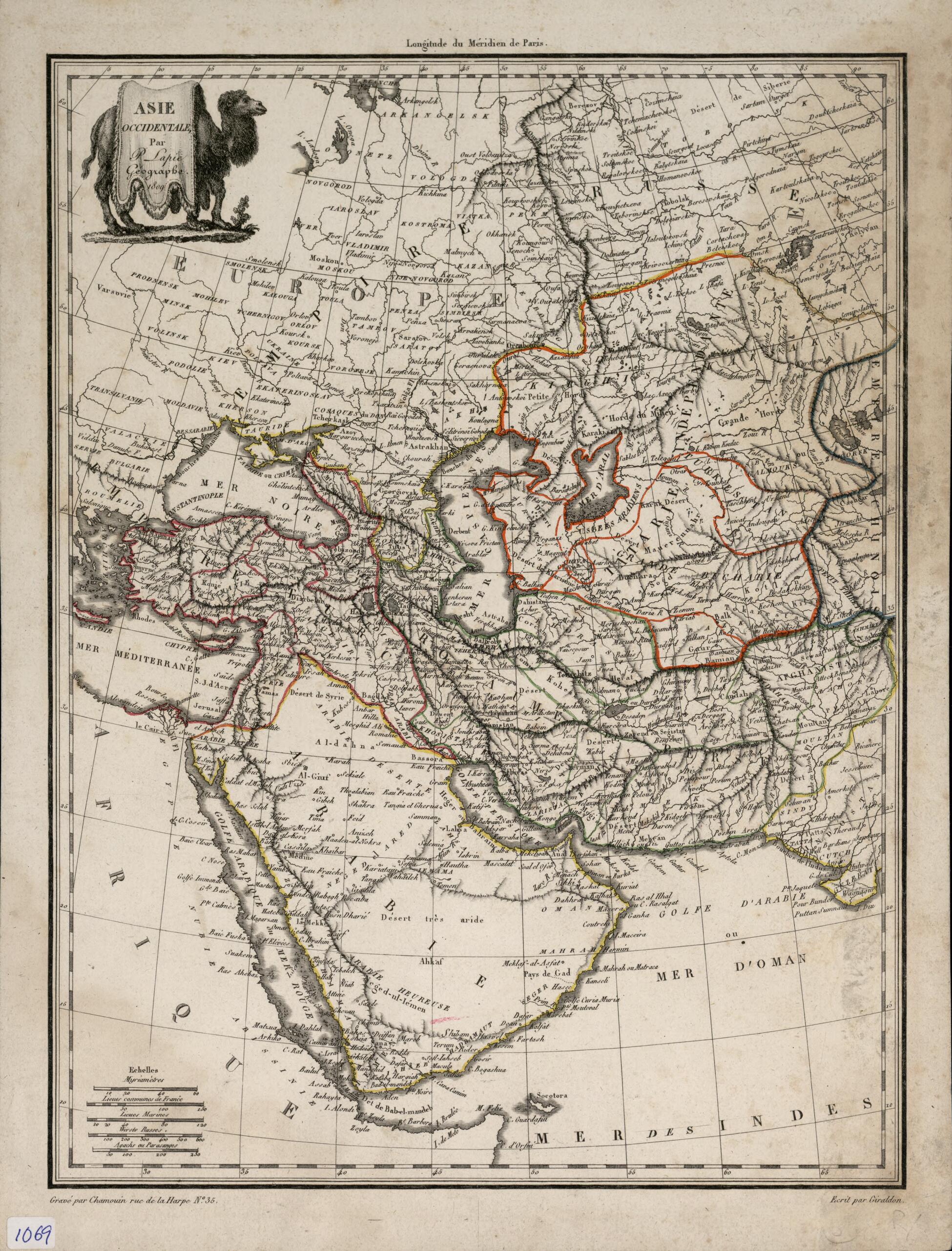
Western Asia. (Asie Occidentale) 1809
- Regular price
-
$49.95 - Regular price
-
$34.95 - Sale price
-
$49.95
Buy one map, get any other map in our collection for 50% OFF! Add to cart to see discount.
Couldn't load pickup availability
About This Map
Discover the timeless beauty of our fine art quality printed reproduction of this antique map. Perfect for history enthusiasts, collectors, and interior decorators.
Restored with meticulous attention to detail by our team with over a decade of experience, this stunning reproduction captures the intricate artistry and historical significance of the original map.
Whether you're a collector or seeking a unique decor piece, this archival-quality map reproduction is a timeless addition to any space. Order now to bring history to life!
Old map of Afghanistan, Armenia, Azerbaijan, Bahrain, Cyprus, Georgia, Iran, Islamic Republic of, Iraq, Israel, Jordan, Kazakhstan, Kuwait, Lebanon, Oman, Pakistan, Qatar, Russian Federation, Saudi Arabia, Syrian Arab Republic, Turkey, Turkmenistan, United Arab Emirates, Yemen.1850). It covers the region between Novgorod and Arkhangelsk, Russia in the northwest and the mouth of the Indus River in the southeast. The southern coast of the Arabian (Persian) Gulf appears as an almost smooth gentle curve, broken only by the mouth of large river called Aftan (present-day Wadi al-Sahba, Saudi Arabia), level with the island of Bahrain. The peninsula and the name Qatar are not shown. The map has an elegant title cartouche in the form of a camel richly draped. Lapie was a colonel in the French army who became head of the topographical section in the Ministry of War. He was assisted by his son Alexandre Emile Lapie (flourished circa 1829--50), also a French military cartographer, who worked with his father over a period of many years. The map provides scales of distance in five different units: myriameters (10,000 meters), leagues, nautical leagues, Russian versts, and Turkish agachs or Persian parasangs. Paris is given as the prime meridian. The engraver was Jean Baptiste Marie Chamouin (born 1768) and the map was drawn by Giraldon Bovinet.
Created by Jean Baptiste Marie Chamouin, Mrs Diot, Flourished Bovinet, M. (Pierre) Lapie, Conrad Brun, 19th Century in 1809.
- Title devised, in English, by Library staff.
- "Published in Précis de la géographie universelle (Summary of universal geography) in 1810 by Conrad Malte-Brun."--Note extracted from World Digital Library.
- Original resource extent: 1 map : hand colored ; 25.5 x 34.5 centimeters.
- Original resource at: Qatar National Library.
- Content in French.
- Description based on data extracted from World Digital Library, which may be extracted from partner institutions.
- For the best legibility, order your map in the original size or larger. Most maps have intricate detail and small text that is best appreciated when the print size hasn't been reduced.
- Sizes labeled "Fits a Standard Frame" will drop right into any frame that you purchase in that size. The sizes that we offer are commonly available online and at most retail stores.
- Our standard sizes are recommendations based on the aspect ratio of the original map, but still may require some added "white space" in one dimension to fit.
- Non-standard sizes will require custom framing, and we suggest taking your print to the frame shop of your choice after you receive it for the best results.
- Custom sizes are available, simply contact us for a quote.
Below is an approximation of the scale of a few standard sizes, and how they might appear in your space.

