
Asiento Present Hordenat a Payon Les Responsions Dels Pezos E Mezures : Delahun Boch Al Altre De Tots Los Presents Bochs Nnomenats Los Quals Son Cap E Regiment De La Mercadoria Hordenat : Mediterraneo E Europa 1563
- Regular price
-
$84.95 - Regular price
-
$79.95 - Sale price
-
$84.95
Buy one map, get any other map in our collection for 50% OFF! Add to cart to see discount.
Couldn't load pickup availability
About This Map
Discover the timeless beauty of our fine art quality printed reproduction of this antique map. Perfect for history enthusiasts, collectors, and interior decorators.
Restored with meticulous attention to detail by our team with over a decade of experience, this stunning reproduction captures the intricate artistry and historical significance of the original map.
Whether you're a collector or seeking a unique decor piece, this archival-quality map reproduction is a timeless addition to any space. Order now to bring history to life!
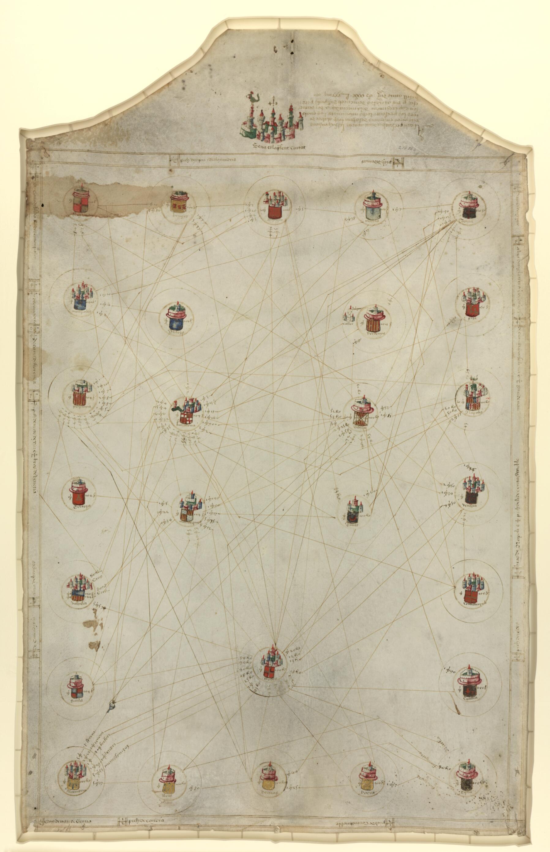
Old manuscript map / early map / nautical chart / aerial view of Europe, Italy, Mediterranean Region, Mediterranean Sea, Siena.Created by Arnald Domenech, Piero Roselli in 1563.
- Diagrammatic map of weights and measures in use in 27 Mediterranean and European seaports.
- Oriented with north to the right.
- Each port city is represented by a vignette of a prominent local tower and the vignettes are connected by rhumb lines.
- Manuscript: pen-and-ink (light brown) and watercolors.
- Includes notes and an aerial view of the walled city of Siena in the upper margin (neck of sheet).
- For the best legibility, order your map in the original size or larger. Most maps have intricate detail and small text that is best appreciated when the print size hasn't been reduced.
- Sizes labeled "Fits a Standard Frame" will drop right into any frame that you purchase in that size. The sizes that we offer are commonly available online and at most retail stores.
- Our standard sizes are recommendations based on the aspect ratio of the original map, but still may require some added "white space" in one dimension to fit.
- Non-standard sizes will require custom framing, and we suggest taking your print to the frame shop of your choice after you receive it for the best results.
- Custom sizes are available, simply contact us for a quote.
Below is an approximation of the scale of a few standard sizes, and how they might appear in your space.

