
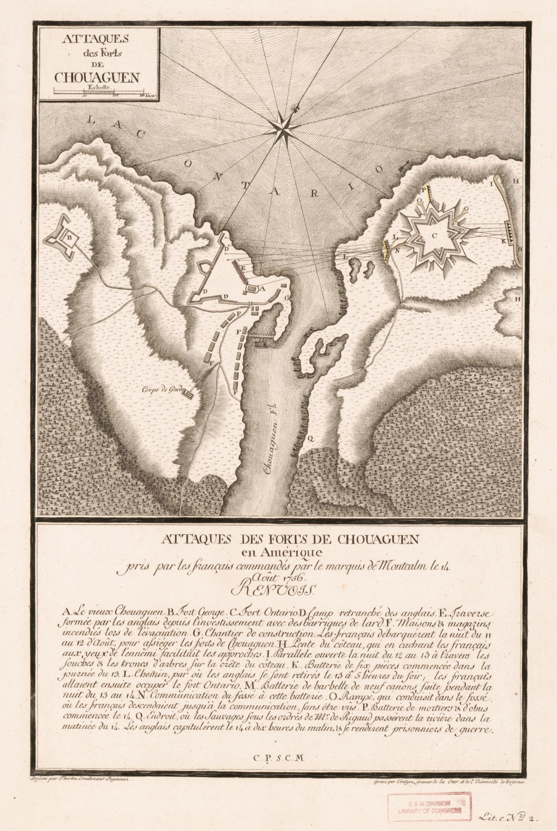
Attaques Des Forts De Chouaguen En Amérique : Pris Par Les Français Commandé Par Le Marquis De Montcalm Le 14 Août 1756
- Regular price
-
$49.95 - Regular price
-
$34.95 - Sale price
-
$49.95
Buy one map, get any other map in our collection for 50% OFF! Add to cart to see discount.
Couldn't load pickup availability
About This Map
Discover the timeless beauty of our fine art quality printed reproduction of this antique map. Perfect for history enthusiasts, collectors, and interior decorators.
Restored with meticulous attention to detail by our team with over a decade of experience, this stunning reproduction captures the intricate artistry and historical significance of the original map.
Whether you're a collector or seeking a unique decor piece, this archival-quality map reproduction is a timeless addition to any space. Order now to bring history to life!
Old early map / military map of Fort Oswego, Fort Oswego (Oswego), New York, New York (State), Oswego, United States.Created by G. J. (Georg Joseph) Cöntgen, L. Therbu in 1756.
- Engraved map of the British fortifications at the mouth of the Oswego River (now in city of Oswego, N.Y.) as depicted by the French.
- Shows military actions taken in the capture of Fort Oswego (August 1756).
- Relief shown by shading and rock drawings.
- This map originally appeared in the atlas "Les plans de la guerre de sept ans" issued in parts between 1789 and 1791 in Mainz (Germany).
- Includes index of battle sites and actions titled "Renvois".
- Number in margin at lower right: Lit. c. N'ro 2.
- For the best legibility, order your map in the original size or larger. Most maps have intricate detail and small text that is best appreciated when the print size hasn't been reduced.
- Sizes labeled "Fits a Standard Frame" will drop right into any frame that you purchase in that size. The sizes that we offer are commonly available online and at most retail stores.
- Our standard sizes are recommendations based on the aspect ratio of the original map, but still may require some added "white space" in one dimension to fit.
- Non-standard sizes will require custom framing, and we suggest taking your print to the frame shop of your choice after you receive it for the best results.
- Custom sizes are available, simply contact us for a quote.
Below is an approximation of the scale of a few standard sizes, and how they might appear in your space.

