
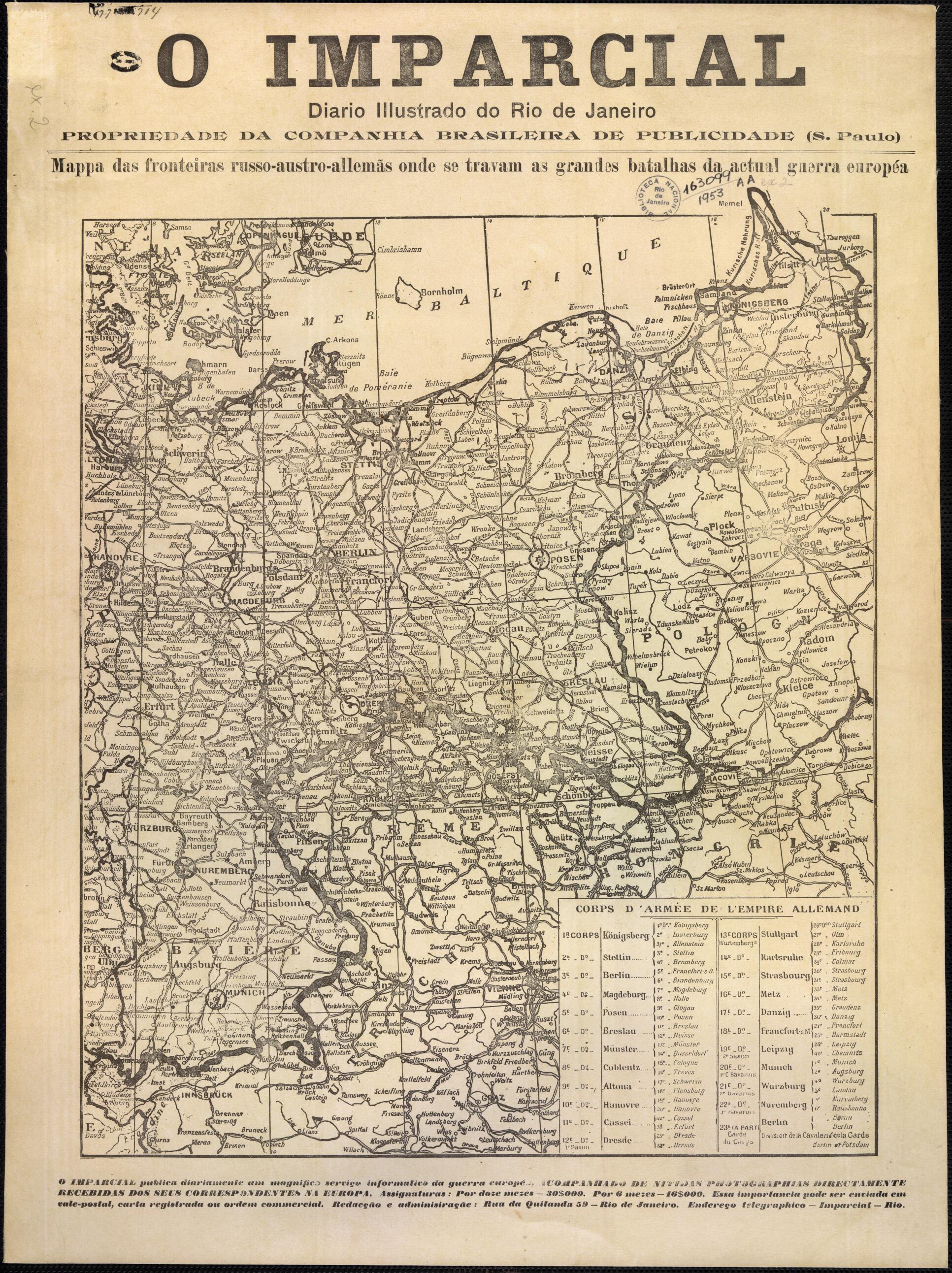
Austrian-German Borders Where the Great Battles of the Current European War Are Fought. (austro-allemãs Onde Se Travam As Grandes Batalhas Da Actual Guerra Européa) 1914
- Regular price
-
$64.95 - Regular price
-
$59.95 - Sale price
-
$64.95
Buy one map, get any other map in our collection for 50% OFF! Add to cart to see discount.
Couldn't load pickup availability
About This Map
Discover the timeless beauty of our fine art quality printed reproduction of this antique map. Perfect for history enthusiasts, collectors, and interior decorators.
Restored with meticulous attention to detail by our team with over a decade of experience, this stunning reproduction captures the intricate artistry and historical significance of the original map.
Whether you're a collector or seeking a unique decor piece, this archival-quality map reproduction is a timeless addition to any space. Order now to bring history to life!
Old map of Austria, Czech Republic, Denmark, Germany, Poland, Russian Federation.Hungary, and the Russian Empire, a member of the Triple Entente allied with Great Britain and France. The map was published by O Imparcial, a leading Rio de Janeiro newspaper, and reflects the keen interest of the Brazilian public in the war in Europe. The title of the map is in Portuguese; the map itself is in French. The table in the lower right lists the 23 army corps that made up the bulk of the German army in 1914. Each corps was based in a different military district and headquartered in a major city in that district. A corps generally was composed of two (in some cases three) divisions. The troops in these divisions were drawn from the cities, towns, and rural areas of the district. German preparations for war were based on the Schlieffen Plan, named after Field Marshall Alfred von Schlieffen (1833-1913), chief of the Imperial German General Staff from 1891 to 1906. Assuming that Germany would have to fight a two-front war against France and Russia, Schlieffen developed a plan that called for using almost the entire German army to win a quick and decisive victory in the west, and then shifting troops eastward to face Russia. The Schlieffen Plan ultimately failed. The Germans were unable to capture Paris and to knock France out of the war, and thus became bogged down in a long conflict in the west at the same time that they and their Austrian allies were fighting Russia in the east.
- Title devised, in English, by Library staff.
- "As printed in O Imparcial newspaper"--Note extracted from World Digital Library.
- Original resource extent: 1 map : black-and-white ; 48 x 36 centimeters.
- Original resource at: National Library of Brazil.
- Content in French and Portuguese.
- Description based on data extracted from World Digital Library, which may be extracted from partner institutions.
- For the best legibility, order your map in the original size or larger. Most maps have intricate detail and small text that is best appreciated when the print size hasn't been reduced.
- Sizes labeled "Fits a Standard Frame" will drop right into any frame that you purchase in that size. The sizes that we offer are commonly available online and at most retail stores.
- Our standard sizes are recommendations based on the aspect ratio of the original map, but still may require some added "white space" in one dimension to fit.
- Non-standard sizes will require custom framing, and we suggest taking your print to the frame shop of your choice after you receive it for the best results.
- Custom sizes are available, simply contact us for a quote.
Below is an approximation of the scale of a few standard sizes, and how they might appear in your space.

