
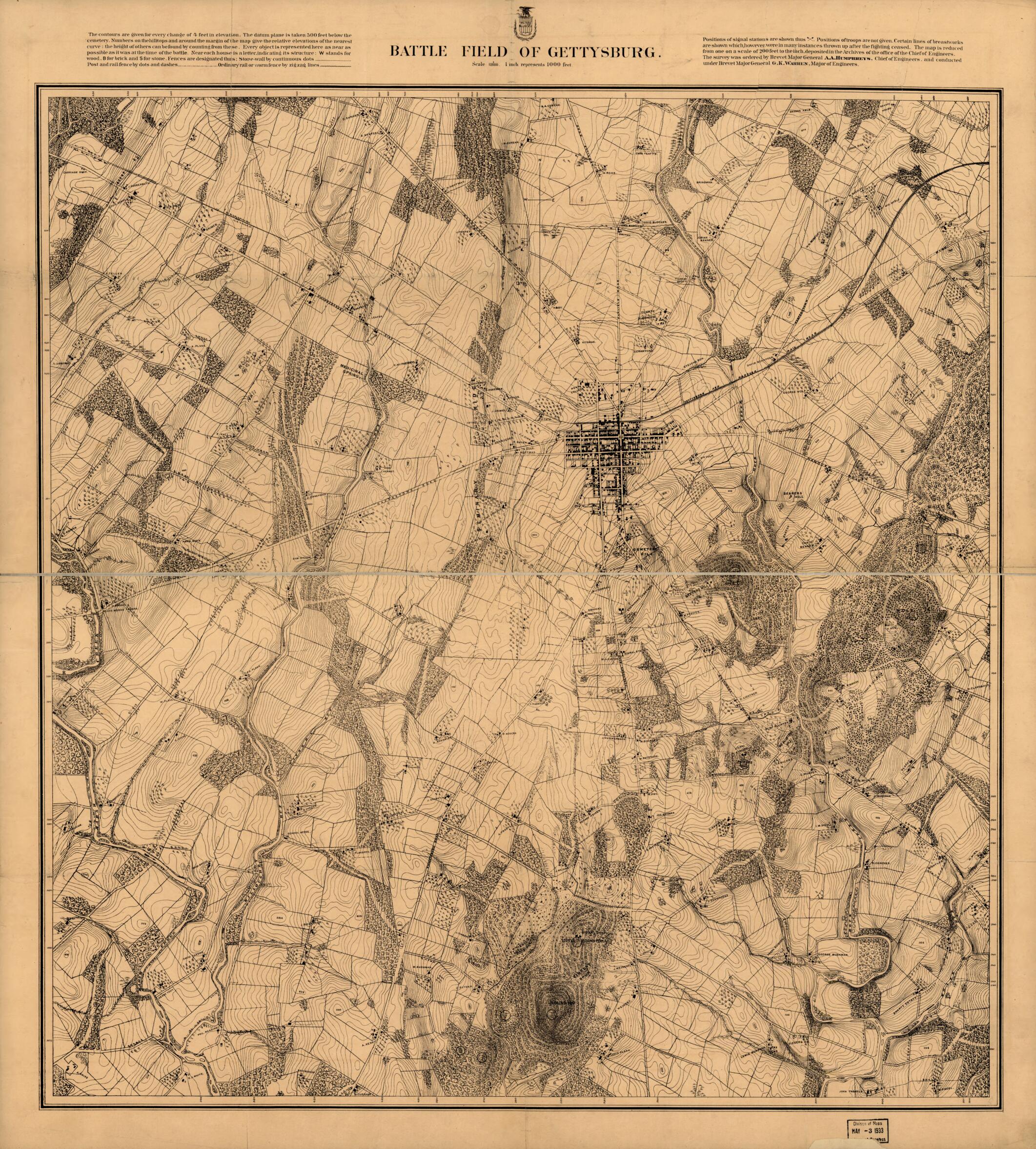
Battle Field of Gettysburg in 1870
- Regular price
-
$101.95 - Regular price
-
$96.95 - Sale price
-
$101.95
Buy one map, get any other map in our collection for 50% OFF! Add to cart to see discount.
Couldn't load pickup availability
About This Map
Discover the timeless beauty of our fine art quality printed reproduction of this antique map. Perfect for history enthusiasts, collectors, and interior decorators.
Restored with meticulous attention to detail by our team with over a decade of experience, this stunning reproduction captures the intricate artistry and historical significance of the original map.
Whether you're a collector or seeking a unique decor piece, this archival-quality map reproduction is a timeless addition to any space. Order now to bring history to life!
Old map of Gettysburg, Pennsylvania, United States.Created by G. K. (Gouverneur Kemble) Warren in 1870.
- Scale 1:12,000 (1 inch equals 1000 feet).
- Civil War Map
- From the Jubal Early Collection in the Manuscript Division, L.C.
- Detailed topographic map subsequently used as the base for John B. Bachelder's "Map of the Battle Field of Gettysburg" (see entry nos. 325 and 326)
- "Positions of troops are not given."
- "The map is reduced from one on a scale of 200 feet to the inch, deposited in the Archives of the office of the Chief of Engineers. The survey was ordered by Brevet Major General A. A. Humphreys, Chief of Engineers, and conducted under Brevet Major General G. K. Warren, Major of Engineers." The survey was made in 1868 and 1869 and revised on the ground by P. M. Blake, Civil Engineer in 1873. The original is in the National Archives, Cartographic and Architectural Branch, Record Group 77:E 81.
- Description derived from published bibliography.
- For the best legibility, order your map in the original size or larger. Most maps have intricate detail and small text that is best appreciated when the print size hasn't been reduced.
- Sizes labeled "Fits a Standard Frame" will drop right into any frame that you purchase in that size. The sizes that we offer are commonly available online and at most retail stores.
- Our standard sizes are recommendations based on the aspect ratio of the original map, but still may require some added "white space" in one dimension to fit.
- Non-standard sizes will require custom framing, and we suggest taking your print to the frame shop of your choice after you receive it for the best results.
- Custom sizes are available, simply contact us for a quote.
Below is an approximation of the scale of a few standard sizes, and how they might appear in your space.

