
Battle of Corunna. 16th January 1809. (Battle of Corunna : 16th January 1809) 1848
- Regular price
-
$49.95 - Regular price
-
$34.95 - Sale price
-
$49.95
Buy one map, get any other map in our collection for 50% OFF! Add to cart to see discount.
Couldn't load pickup availability
About This Map
Discover the timeless beauty of our fine art quality printed reproduction of this antique map. Perfect for history enthusiasts, collectors, and interior decorators.
Restored with meticulous attention to detail by our team with over a decade of experience, this stunning reproduction captures the intricate artistry and historical significance of the original map.
Whether you're a collector or seeking a unique decor piece, this archival-quality map reproduction is a timeless addition to any space. Order now to bring history to life!
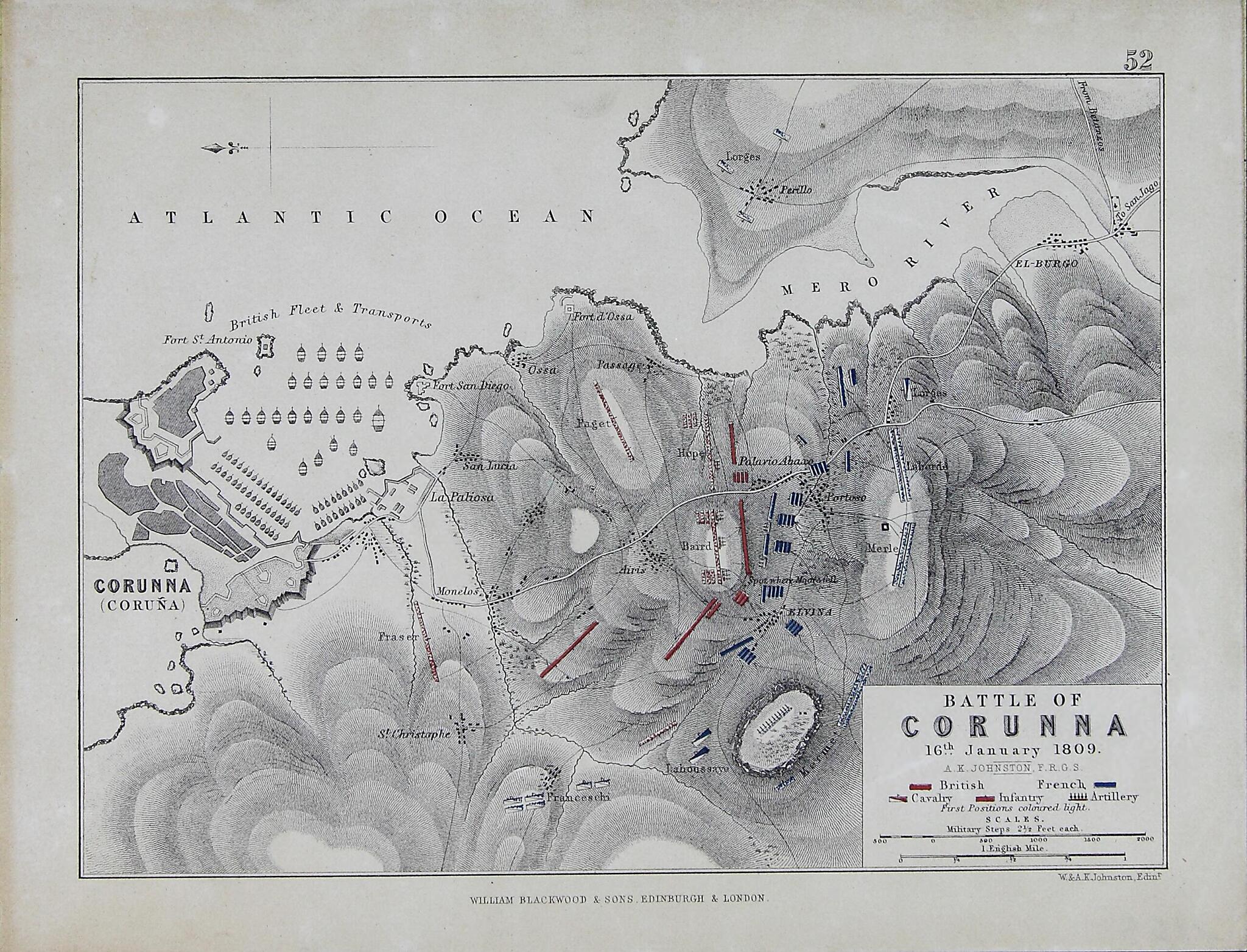
Old map of A Coruña, Galicia, Spain.14, a conflict that is referred to in Spain as the Guerra de la Independencia (War of Independence). The war pitted the armies of Britain, Spain, and Portugal against the Napoleonic armies of the First French Empire in a fight for control of the Iberian Peninsula. This map appeared in the Atlas to Alison's History of Europe, the result of a collaboration between historian Archibald Alison (1792-1867) and the Scottish geographer and cartographer Alexander Keith Johnston (1804-71). Scale is marked in military steps (1 military step = 0.76 meter) and in miles (1 mile = 1.61 kilometers), and north is oriented to the left. The British initially did not fare well in the campaign, and in December 1808 they retreated at speed toward La Coruña to be evacuated by the fleet. There the exhausted British troops commanded by Major General Sir John Moore, who died on the field of battle, faced numerically superior French forces under Marshal Soult. The French attack was driven off sufficiently for the British to be able to embark on the transports for home that night and the next day. The British army returned to the Iberian Peninsula in May 1809 under the command of Sir Arthur Wellesley, later first Duke of Wellington.
Created by Archibald Alison, Alexander Keith Johnston, William Johnston in 1848.
- Title devised, in English, by Library staff.
- Original resource extent: 1 map : lithograph, black-and-white ; 19 x 24 centimeters.
- Original resource at: Library of Galicia.
- Content in English.
- Description based on data extracted from World Digital Library, which may be extracted from partner institutions.
Map Subjects
01-16
A Coruña
Battlefields
Battles
Galicia
La Coruña Battle Of La Coruña Spain
Napoleonic Wars
Peninsular War
Spain
Archibald Alison
Alexander Keith Johnston
William Johnston
1848
- For the best legibility, order your map in the original size or larger. Most maps have intricate detail and small text that is best appreciated when the print size hasn't been reduced.
- Sizes labeled "Fits a Standard Frame" will drop right into any frame that you purchase in that size. The sizes that we offer are commonly available online and at most retail stores.
- Our standard sizes are recommendations based on the aspect ratio of the original map, but still may require some added "white space" in one dimension to fit.
- Non-standard sizes will require custom framing, and we suggest taking your print to the frame shop of your choice after you receive it for the best results.
- Custom sizes are available, simply contact us for a quote.
Below is an approximation of the scale of a few standard sizes, and how they might appear in your space.

